|
February 2017 Newsletter |
|||
|
|||


Website | Contact Us | Pricing | Live Demo | Free Trial | Reviews
Maptitude 2017 Adds Enhanced MapPoint and Streets & Trips Features!
Maptitude 2017 dominates the space vacated by MapPoint, supporting Microsoft MapPoint-like tools & queries. With enhanced versions of the features that MapPoint users are familiar with, Maptitude retains the ease-of-use of the MapPoint tools while providing functionality that Microsoft users could only wish for.
The new and improved tools include:
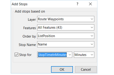
- Route/directions management: Importing MapPoint and Streets & Trips waypoint files along with stop number, name, and stop time.
- Territory management & import: Importing MapPoint territory files that have no data columns or that have County and State information in separate columns.
Maptitude is Feature Equivalent to MapPoint and supports MapPoint files:
|
|
|
New Maptitude 2017 Routing Features:
- If your vehicles have specified stop times in an Excel table, Maptitude 2017 can automatically apply them.
- Maptitude 2017 allows you to specify a default stop time for all your destinations.
- To better manage your routes, you can also lock the first and last stops, specify the route color, and click in the directions to label route segments.
- A new distance and drive-time tool creates an Excel table that lists the costs of travel between any number of origins and destinations. You can now quickly identify the closest and backup locations ranked by travel time or distance.
- Drive-time rings can be created down to 1 minute intervals.
- Routes can be immediately exported to Excel along with the longitude and latitude of each stop.
- Excel export tool: The one-click Export to Excel report now automatically includes travel time and distance and can be used with more map data. For example, you can filter the postal/ZIP Codes that you are interested in and then immediately create a demographic report in Excel.
Please contact the Maptitude Sales Team with any questions. View a new Maptitude 2017 video here.


|
“So how did my experience of Maptitude turn out - well it's fantastic. I have achieved everything I wanted to be able to do, and more, regarding analyzing business data for all sorts of industries.” Stephen Kilbee Owner, COVERPOINT. Read the Case Study here |
Featured Map
Where the Coffee is Brewing: Largest Coffee Chain by County
The 2017 Country Packages include an updated point landmark database that includes thousands of retail stores and restaurants, including coffee shops in the United States. The map below shows the concentration of coffee shops by county and what the most common chain is in each county.
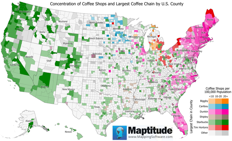
The two largest chains by far are Starbucks and Dunkin Donuts, followed by Tim Hortons, Caribou, and The Coffee Bean & Tea Leaf. Starbucks is predominant in 574 counties, including the entire western half of the country, Dunkin Donuts is predominant in 399 counties, mostly on the East Coast, Caribou Coffee is predominant in its home state of Minnesota, and Biggby is predominant around its home city of East Lansing, Michigan. Canadian coffee brewer Tim Hortons is also making some inroads in the Northern United States.
Tech Tip
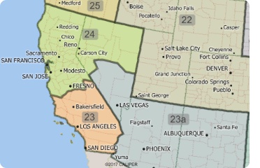
How do I import my MapPoint territory layer
|
|
Maptitude 2017 makes it even easier to create territories from your MapPoint files. Territory creation was one of the best features of Microsoft MapPoint and has been improved in Maptitude 2017! Not only can you import territories that have no data fields, but you can also create territories with State and County information in separate fields, which was the MapPoint default. Once you have chosen to open a MapPoint PTM file, Maptitude automatically walks you through the simple steps to create your territories. A territory layer is created that can immediately be used to create Excel reports with a demographic breakdown sheet, plus sheets for any other data that you have mapped and that fall within your territories. |
Tricks & Tips
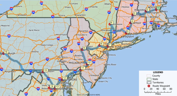
Importing MapPoint Routes
|
|
The Maptitude Routing Manager makes it easy to create and manage your routes. The ability to control the characteristics of the route and each waypoint, such as itinerary and driving speeds, is a critical step in the planning of your routes. This was one of the best features of Microsoft MapPoint and is part of Maptitude 2017! You can now import route waypoints from MapPoint, Streets & Trips, and AutoRoute. Simply choose File-Open, choose your Microsoft file type, and Maptitude adds them as a new point layer. By clicking the Add Locations button in the Routing Manager, you can then load the waypoints along with the stop order, names, and stop time. |
Learning
Free MapPoint Webinar; New Maptitude 2017 Videos; UK & USA Training Dates for Maptitude 2017!

|
|
MapPoint Webinar: This webinar will help MapPoint users new to Maptitude 2017. We will discuss mapping your data, changing the styles on a map, getting reports on custom-defined areas, creating drive time rings, the hover label tool and creating territories. There is also a free class handout here. |


