|
Featured Maptitude Maps:
3-D
Educational Performance Map
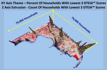
This month we showcase a 3D map of
Florida.
The map shows DTEIA™ Scores (a measure
of student performance). Using
Maptitude, the data are
aggregated to 6x6 square mile grids in 3D over a 2D surface. This
allows the mapping of those areas
that have a high percent, and/or a high
count, of underperforming households.
"Maptitude includes a function that
creates a grid of user specified size
and number of points. I created a
thematic map of percentages of selected
values as indicated by the DTEIA
algorithm. The points and attributes
were input to the 3D Map. I dropped
images of the 3D map into
Microsoft PowerPoint. My objective was
to convey the meaning of complex
geospatial algorithms and big data to
business leaders, and its importance to
them at their specific locations, to
guide them toward decisions based upon
best practices." (Grant Thrall)
Map
created by Grant Ian Thrall Ph.D., used with
permission
More Featured Maps...
If you would like to see your maps showcased here,
or are interested in custom map making services and
software please
contact
Caliper.
Focus on Maptitude:
Sneak Preview!
Visualization Enhancements in Maptitude
2014
Maptitude 2014 is due out in the first quarter of
2014, and we are offering you an exclusive first
look at some of the new features.
Maptitude 2014 will bring improvements
to a number of areas of the software.
One of the key areas of focus is
significantly enhanced visualization
capabilities. The objective of these
improvements is to make it easier to
present the results of your analysis as
stunning and compelling graphics.
Maptitude now supports completely new
ways to see your data, including
seamless aerial image backgrounds, ring
analysis
demographic reports, and 3D maps.
|
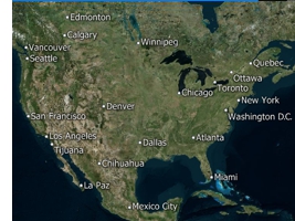
Web
Map Layers
Maptitude 2014 gives you access to
aerial, road, terrain, and hybrid map
layers that can serve as distinctive
backgrounds to your maps. These layers
are visually attractive and support a
range of tasks including real estate
site exploration.
|
 |
|
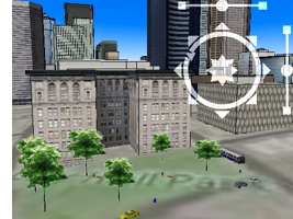
3D Views
Working seamlessly within Maptitude, the
3D View allows you to map in 3
dimensions as a way of exploring
locations with an audience. You can build a 3D scene from the huge number of
Maptitude models and any combination of
SketchUp, VRML, or 3DS models, such as
buildings and landmarks. |
|
|
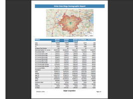
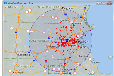
Reports
In Maptitude 2014 you can now create
high quality reports that can be
automatically output when conducting
ring and drive-time analyses. The report
templates present your demographic and
site analyses much more quickly and
professionally than in previous versions
of the software.
|
|
More to come! There are many more
improvements in Maptitude 2014. Stay
tuned for more information! Please contact our
Maptitude Sales Team with any questions.
Using Outdated
Data & Technology?
Upgrade to Maptitude 2013!
Users of Maptitude 2012 and Maptitude
6.0 can still get our US$395
reduced upgrade pricing. This
deal
saves you US$300! Upgrade now to avoid
being caught out by using last year's
features and data. If you upgrade now,
you can
pre-order your Maptitude 2014 upgrade
for only US$195!
Also, each US order will include a free US
ZIP Code update: a US$250 value! The
combination of the offer and free data saves
you US$550!
For pricing and ordering information
please visit the
Mapping Software Store, e-mail
Maptitude Sales, or call U.S. Sales
at +1 617-527-4700.
Limited Offer: Valid for Maptitude 6.0
or later.
Restrictions Apply.
You need the newest maps, the latest
demographics, and the fastest, most
intuitive Maptitude!
  |
| |
|
Maptitude 2014 Training (New!):
Limited Availability
 New sections cover Maptitude 2014!
Advance
registration for the instructor-led training courses is required.
Upcoming classes: New sections cover Maptitude 2014!
Advance
registration for the instructor-led training courses is required.
Upcoming classes:
•
March 3-5: Boston MA
Space is limited, so
register online as soon as possible.
If you have any questions, please call Maptitude
Training (USA) at +1 617-527-4700, or send
an e-mail to
sales@caliper.com.
|
Maptitude International News:
Beta Menu
Translation Tool: Chinese
Maptitude
includes the Geographic Information System Developer's Kit (GISDK™).
Over 700 functions can be called from Caliper Script, a complete
programming language for designing menus and dialog boxes (including
toolbars and toolboxes) and for writing macros. You can develop
add-ins that extend the standard interface to provide new
capabilities or that automate repeated operations.
There are several such
free mapping tools, here.
You can download any of the
add-ins to extend the
capabilities of Maptitude. This
month we have released a new
add-in that translates the
Maptitude menu items (not dialog
boxes, tools-tips, or messages)
into Chinese. This
beta translation tool is
available here.
|
|
Did You Know?
Finding
Nearest Stores & Distances To Them
 Maptitude
lets you fill a field in a map
layer table with data from
another layer by using the Edit-Fill-Tag tool.
You can, for example, fill in a
field with the name of the
nearest feature in another map
layer or with the distance to
the nearest feature in another
map layer. This is called
tagging. Maptitude
lets you fill a field in a map
layer table with data from
another layer by using the Edit-Fill-Tag tool.
You can, for example, fill in a
field with the name of the
nearest feature in another map
layer or with the distance to
the nearest feature in another
map layer. This is called
tagging.
For example, suppose you are
looking at a table of customers.
You could fill in one column in
the table with the distance to
the nearest store and a second
column with the name of the
nearest store (Maptitude
Video...).
|
Maptitude
News and Press:
•
Grant Thrall Keynote Speech to Florida
Realtors Summit: Location & Consumer
Behavior (Dec. 10, 2013)
•
Detroit Area Bank Branch Locations
•
Caliper Brings Site
Location Analysis to
Real Estate with the
Free Maptitude MassStats
Application
•
KQED: Oakland's
Low-Income Communities
Look to Gain Electoral
Power Through
Redistricting
•
More Maptitude News...
Maptitude
Solutions:
Banking GIS
Business Mapping
Census Data Mapping
Community Development
Election Management
Enterprise GIS
Franchise Mapping
GIS Software
GPS Mapping
Insurance Mapping
Law Enforcement GIS
Location Intelligence
Marketing & Sales Mapping Software
Public Health Mapping
Real Estate Mapping
Redistricting
Route Planning & Deliveries
Satellite & Aerial Imagery
Street Mapping
Territory Mapping
Web Mapping
World Mapping
|
|
Tech Tip:
Site
Location Using the Weighted Center Tool
Corporate and government relocation is a
growing segment of the real estate
industry. Corporate mergers,
reorganizations, and upsizing/downsizing
often prompt a move to a new address. An
office move is an event that typically
takes place several times in the
lifecycle of a company, on average once
every 5 to 10 years.
 If you're planning on moving your
business it is critical to find
commercial real estate that meets the
requirements and goals of your
organization. Do you want to relocate
near to the homes of upper management,
or do you want a more central location
to reduce average employee commute time? If you're planning on moving your
business it is critical to find
commercial real estate that meets the
requirements and goals of your
organization. Do you want to relocate
near to the homes of upper management,
or do you want a more central location
to reduce average employee commute time?
The Weighted Center of gravity tool
involves plotting all of your locations
on a map and then finding a central
location that is closest to those points
with the highest weighted demand. For
example, if you are considering
relocating a store, Maptitude can create
a trade area around your customers and
weight the center by their sales volume
to determine a new candidate location.
Alternatively, you may have a database
of client employees. You can use
Maptitude to see the best central
location based on the density and
distribution of the addresses. These
could be weighted by seniority, allowing
you to better explore potential site
locations by considering staff
characteristics.
Maptitude is widely used to conduct
site,
territory,
and
marketing research. For example, new stores
can be considered in locations where there is a gap
in the market, and sales campaigns can be conducted
to assess the market potential. By cross-referencing
data from multiple sources, such as loyalty schemes and
demographics, it is even possible to prioritize
certain opportunities to better inform real
estate decisions.
The
following steps illustrate how to create a weighted
center for your
locations:
-
Choose the point layer from the drop-down list on
the Standard toolbar.
-
Choose Tools-Geographic
Analysis-Weighted Center to display
the Weighted Center dialog box.
-
Choose to use All Features or a selection set from
the Selection Set drop-down list.
-
From the Weighting Field drop-down
list choose one of the point layer fields to place
the facility at the weighted center of the locations
of the set of points
-
Choose how to save the results from the Save Results
As drop-down list
-
Click OK. Maptitude displays the
Save As dialog box. Type a file
name for the new geographic file, and click
Save.
-
Maptitude creates new layers containing the weighted
center and service area and adds the new layers to
the map.
To insert your results into a presentation you can
choose File-Save As to export your map for use outside
of Maptitude.
|