|
July 2017 Newsletter |
|||
|
|||


Website | Contact Us | Pricing | Live Demo | Free Trial | Reviews
Want More Free Premium Data?
Point of Interest (POI) Layers by Type are Now Available for Maptitude 2017!
Point
files with the locations of all the
points of interest across the USA are now
downloadable for free for Maptitude 2017
users only. Don't have Maptitude
2017?
Purchase or upgrade to Maptitude 2017 to use this premium business data.
Last month we provided the locations of businesses across the USA by individual brand. This month the free layers are sorted by category. The download includes point layers for 86 categories of location in the USA, including shopping malls, banks, restaurants, and hospitals. These new layers are perfect for site location, competitive analysis, routing, and real estate reports. The layers have attractive icons and can be added to any Maptitude 2017 map.
Maptitude includes a vast amount of business-critical data at no additional cost, such as demographics, boundaries, streets, and the most accurate ZIP Code/postal boundaries available.
![]()
![]()
 |
What do you like best about Maptitude? “Ease of use, free US and world data, an exhaustive library of features, ability to automate tasks using GISDK, ease of training new users, amazing tech support, robustness and well thought-out user interface.” Andrew Kolcz VP Systems, ETC Institute |
Featured Map:
Closest Major League Baseball Park Based on Drive Time
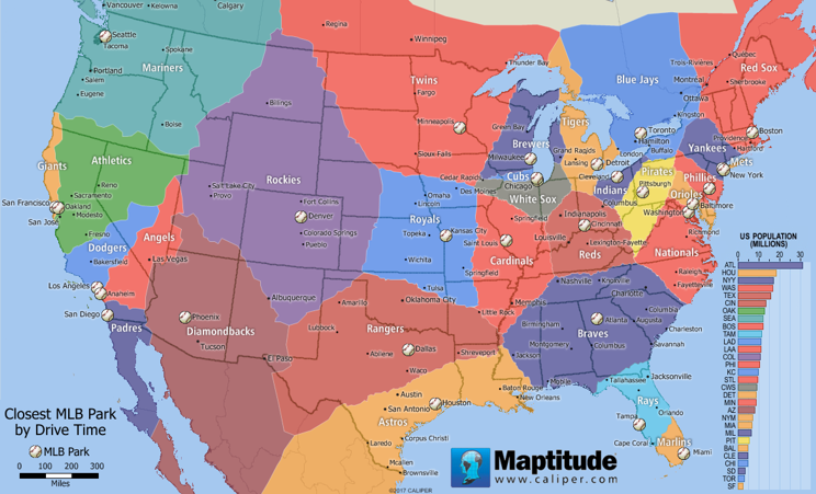
Are you planning on taking a road trip this Summer that includes a baseball game? This month's featured map shows North America divided into territories based on the shortest drive-time to a Major League Baseball park. We have also calculated the portion of the U.S. population that lives within each area. Our analysis with Maptitude included some interesting results for baseball fans:
- Baseball fans in Iowa may have the toughest choice in choosing their team alliance. While the state has no team of its own, six different teams lay claim to portions of the state to which they are closest (Twins, Royals, Cardinals, White Sox, Cubs, and Brewers).
- While New York is home to two MLB teams, your location in the state will determine which of seven different teams (Mets, Yankees, Blue Jays, Phillies, Pirates, Indians, and Red Sox) is closest.
- Thanks to the 2½-hour Lake Express Ferry, baseball fans in Grand Rapids, Michigan can get to a Brewers game in less time than it takes to drive to see their home state Detroit Tigers.
- While Illinois may be home to two teams, more than half of the state is closer to Busch Stadium in St. Louis, Missouri.
- Portions of 13 states and one Canadian province are closest to Coors Field in Denver, Colorado.
- The smallest territory by area belongs to the New York Mets, where only people living on Long Island can claim Citi Field as their closest park.
- 31.3 million Americans (nearly 1/10 of the entire population) live closest to Suntrust Park, the new home of the Atlanta Braves.
- Even though the Blue Jays play in Canada, their territory contains 3.2 million people who live in western New York, which exceeds the San Francisco Giants territory at only 2.7 million people.
The 2017 USA Maptitude Country Package includes a point landmark database that includes thousands of points-of-interest, including baseball parks, stadia, and sports complexes.
Tech Tip:
How Do I Download the Free U.S. Point of Interest Layers for Maptitude 2017?
The point of interest map layers for Maptitude 2017 are accessible as a free download. In this tech tip we describe how to install the layers and add them to a map.
Tricks & Tips:
Performing a Drive-Time Ring Analysis Using the U.S. Point of Interest Layers
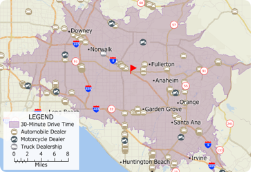
When you have added one or more point of interest layers to your map as described in the above Tech Tip, you can then perform a drive-time ring analysis on those layers. For example, you could add the automobile, motorcycle, and truck dealership layers to the map and then determine how many of each type of dealership is within a 30-minute drive of a location.
Using the Drive-Time Rings toolbar (Tools > Routing &
Directions > Drive-Time Rings) you can create a
drive-time ring around your target location. You can then make the
new drive-time layer the working layer and click
 on the
Standard toolbar.
The resulting Excel file will contain a sheet for each
point-of-interest layer showing exactly which features are in the study area.
on the
Standard toolbar.
The resulting Excel file will contain a sheet for each
point-of-interest layer showing exactly which features are in the study area.
If you do not want a certain layer to appear in the report then you can turn the layer off in the Display Manager (e.g., Hide the City/Town layer before exporting to Excel to exclude city/town information).
Learning Maptitude:
Webinars and Training Dates for Maptitude 2017
 |
Upcoming Training: |
|
 |
2017 Webinars (Free)! |


International Mapping:
| www.caliper.com |
Copyright ©2017, Caliper Corporation. All Rights Reserved. |