|
June 2017 Newsletter |
|||
|
|||


Website | Contact Us | Pricing | Live Demo | Free Trial | Reviews
Want More Free Premium Data?
Business & Point of Interest (POI) Layers are Now Available for Maptitude 2017
Point
files with the locations for some of the
largest U.S. businesses are now
downloadable for free for Maptitude 2017
users only. Don't have Maptitude
2017?
Purchase or upgrade to Maptitude 2017 to use this premium business data.
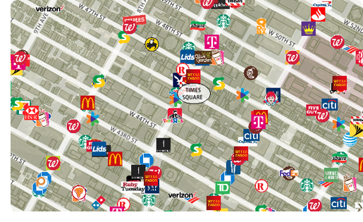
The download includes point layers for 402 U.S. businesses, including many of the largest bank, restaurant, and retail chains. These new layers are perfect for site location, competitive analysis, routing, and real estate reports. The layers have company logos and can be added to any Maptitude 2017 map.
Maptitude includes a vast amount of business critical data at no additional cost, such as demographics, boundaries, streets, and the most accurate ZIP Code/postal boundaries available.
![]()
![]()
 |
“Maptitude is simple to use and inexpensive, but is powerful and packed with valuable data. I've used it for over 15 years and love it! ” Jason Black Director of Advancement Services Columbia College |
Featured Map:
Largest Pizza Chain by State
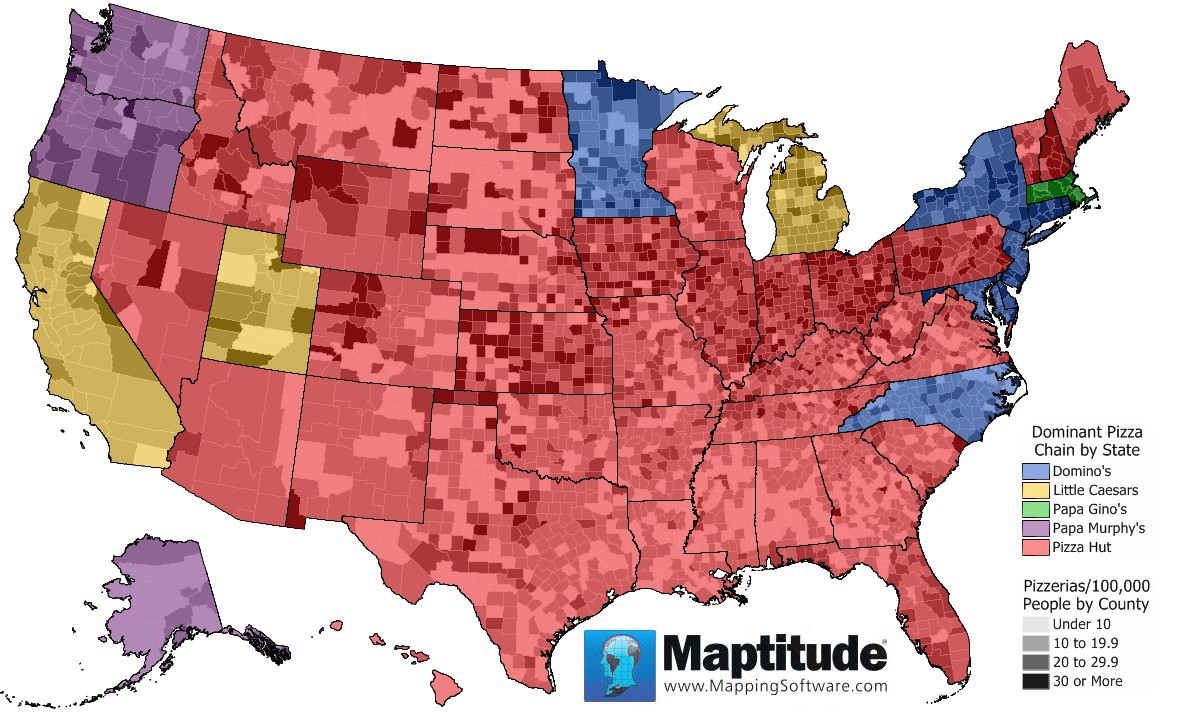
The 2017 Maptitude Country Packages include an updated point landmark database that includes thousands of restaurants, including national and regional pizza chains. This month's map shows the concentration of pizzerias by county and what the most common chain is in each state. In this map you can see that there is a somewhat higher concentration of pizzerias in the counties of the northern and plains states.
Pizza Hut, with over 6600 restaurants, is the dominant chain in 36 states, followed by Domino's (5000 restaurants) in 8 states and the District of Columbia.
Tech Tip:
How Do I Download the Free U.S. Business Layers for Maptitude 2017?

The business point of interest map layers for Maptitude 2017 are accessible as a free download. In this tech tip we describe how to install the layers and add them to a map.
Tricks & Tips:
Performing a Drive-Time & Radius Analysis Using the U.S. Business Layers
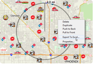
When you have added one or more business layers to your map as described in the above Tech Tip, you can then perform a drive-time and radius analysis on those layers.
Using the Drawing Toolbar (Edit > Drawing > Toolbar) you can use the Freehand Radius tool to click and drag a circle or to single click and enter a radius. You can then right click on the circle and choose Export to Excel. The resulting report will contain a demographics (overlay) sheet, and sheets for each business layer showing the attributes of the businesses as well as the straight-line distance and travel-time from each location to the circle center.
If you do not want a certain layer to appear in the report then you can turn the layer off in the Display Manager (e.g., Hide the City/Town layer before exporting to Excel to exclude city/town information).
Learning Maptitude:
Webinars and Training Dates for Maptitude 2017
 |
Upcoming Training: |
|
 |
2017 Webinars (Free)! |


| News | ||
|
International Mapping:
| www.caliper.com |
Copyright ©2017, Caliper Corporation. All Rights Reserved. |