|
Upgrade to Maptitude 2015 for US$395:
Only 1 Month Left!
For a short time we are extending our US$395
reduced upgrade pricing to
include
licenses
older than Maptitude 2013. This deal saves
you US$300! Also, each US order will include a free US
ZIP Code update: a US$250 value! The
upgrade offer and the free data together
save you a total of US$550!
 If
you don't know which version of
Maptitude you have, or if you have an
old
license of Maptitude,
contact
us to
check on your eligibility for upgrade
pricing.
The original media/software and
user are not required to upgrade. If
you don't know which version of
Maptitude you have, or if you have an
old
license of Maptitude,
contact
us to
check on your eligibility for upgrade
pricing.
The original media/software and
user are not required to upgrade.
Maptitude 2015 is
a major new release. Stop using outdated
information and get the most detailed
and accurate data
and demographics ever
included (more...)

Limited Offer: Valid until June
30, 2015.
Restrictions
Apply.
|
|
Sneak Peek! Maptitude
Territory Manager |
|
We are excited to announce a
completely new territory tool
suite that was developed based
on extensive customer feedback.
We value user suggestions as
they allow us to continually
improve our mapping software.
Maptitude gives you a set of
territory creation tools that
will satisfy your business
mapping needs (more...).
The new features include:
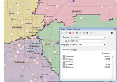 Territory Mapping Wizard Territory Mapping Wizard
A new
intuitive wizard walks you
though the territory creation
process. You can build your
territories using an existing
table/spreadsheet, an existing
area or point layer, or manually
by clicking on a map.
Territory Mapping Tool Pane
A new tool pane allows you to
quickly and easily manage and
edit your territories. Your
territories can be modified
simply by interacting with the
map, by filtering based on
attributes, or by
grabbing all the ZIP Codes
within a state or county. You
can use any geography layer,
overlap territories, and easily
keep track of one or more
balancing totals such as
population. There is also full
undo/redo support and single
click export to Excel!
|
"Caliper's tool was instrumental
in developing and maintaining
the international markets of a
leading multichain restaurant.
The popular restaurant brand was
facing problems in managing
their franchise territories,
while the need to integrate
disparate sources of business
data has escalated. To overcome
this, Caliper used their
trademark product Maptitude to
simplify territory
identification and allocation,
as well as to improve franchisee
satisfaction by providing
insightful market intelligence
thereby increasing opportunities
for success." CIO Review |
|
|
|
Featured Maptitude Map:
Government
Employees for the 50 States (USA) Using Maptitude 2015
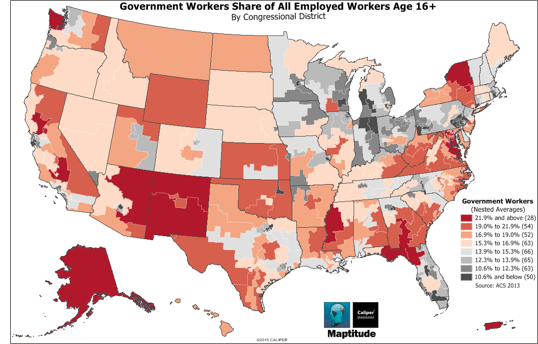 This month's featured map uses a
nested averages heat/color theme by
congressional district to show those
districts that have
more or less than the average number of
government employees as a percentage of
total employees. Alaska is notable for
being above average, with the Federal
Government traditionally being the
largest employer in the state. This month's featured map uses a
nested averages heat/color theme by
congressional district to show those
districts that have
more or less than the average number of
government employees as a percentage of
total employees. Alaska is notable for
being above average, with the Federal
Government traditionally being the
largest employer in the state.
Maptitude 2015 includes detailed data
for the entire of the USA and Puerto
Rico, data that can be used to create
engaging and informative reports.
Maptitude supports several tools for
report sharing, including: direct export
to an image file, printing to
customizable paper sizes, PDF output,
automatically created HTML and Excel
reports, and print preview layouts.
You can even share data for the entire
country in a single comprehensive view.
Maptitude, a full-featured but
easy-to-use mapping application, creates
polished reports with a single click,
allowing direct sharing of geographic
analysis. You can: seamlessly switch map
backgrounds to show aerial photo-imagery
or terrain, create visually stunning 2-D
or 3-D maps, and customize any element
of your map display. If you
have any questions, please
contact Caliper.
»
More Featured Maps
|
"While information
from each of the windows (maps,
figures or dataviews) can be
saved or printed directly, the
layout allows the user to create
an output of all of the elements
together." Michael Cline,
DirectionsMag.Com
|
|
|
Tech Tip:
How Do I
Use Layouts to Create a Wall Sized Map?
Whether you need a wall-sized map,
city-wide street level detail, or large
area coverage, Maptitude has the tools
to get the job done. In this tech tip
we describe how to use Layouts to create
the custom output you require.
»
Learn How Here
|
|
Video: Layout
Reports Video
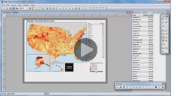 This
month we have released a new video that
covers creating Layout reports in
Maptitude 2015. Learn how to insert and
manipulate maps, tables, and other
graphical elements.
The video is available here. This
month we have released a new video that
covers creating Layout reports in
Maptitude 2015. Learn how to insert and
manipulate maps, tables, and other
graphical elements.
The video is available here.
|
|
 Tricks & Tips:
Saving
Layouts to Image Files Tricks & Tips:
Saving
Layouts to Image Files
Maptitude
2015 users can save maps and reports to
many
raster and vector formats. When
saving to an image format for
insertion into MS Office and other
external applications, you can specify
the quality and resolution of the
graphic.
In the File-Save As
dialog box, choose a picture file from the
Save as type drop-down
list, then
simply click the Options
button to edit the output. The maximum
resolution is set as 300 DPI but you can
manually override this by typing in your
preferred level of detail.
|
|
|
|
|
|
|
|