
NEWTON,
MASSACHUSETTS – Caliper® Corporation has announced the
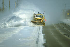
development of an automated snow plow routing application for the Hennepin
County Department of Public Works (DPW). Developed using Caliper
Corporation’s
TransCAD® transportation
planning software, the application will
generate snow plow routes for an area covering Hennepin County, Minnesota.
 At
the onset of a snowstorm, Hennepin County DPW dispatches separate fleets of
snowplows to service county highways. Snow plows operate individually or as
a part of a multiple-truck team to improve driving conditions by clearing
snow from driving lanes and shoulders, and spreading sand or salt to
increase traction and accelerate melting. In prior years, snowplow routes
were created manually and were designed to return highways to acceptable
driving conditions within a pre-defined "cycle time," i.e. the time
necessary to service all highways in a route.
At
the onset of a snowstorm, Hennepin County DPW dispatches separate fleets of
snowplows to service county highways. Snow plows operate individually or as
a part of a multiple-truck team to improve driving conditions by clearing
snow from driving lanes and shoulders, and spreading sand or salt to
increase traction and accelerate melting. In prior years, snowplow routes
were created manually and were designed to return highways to acceptable
driving conditions within a pre-defined "cycle time," i.e. the time
necessary to service all highways in a route.
The automated
snow plow routing application strives to increase the level of service and
to decrease operating costs by reducing snow plow "deadheading." Deadheading
is defined as time when the truck is moving but the plow blade is not in
service, e.g. driving from the truck station to the start of a route, or
driving between service areas. In addition, the application attempts to
create routes that balance cycle times.
Reports generated
by the application include route descriptions that list highways to be
serviced in a single route, the number of trucks assigned to a route, and
the originating truck station for each route. Routes are also displayed in
color maps and are further described in statistical reports that describe
service time and deadhead time.
TransCAD
Transportation GIS Software provides an extended GIS data model that is
designed to support transportation applications, including routing and
logistics. TransCAD supports the creation of transportation networks and the
integration of procedures for network partitioning and vehicle routing. The
commercial, off-the-shelf version of TransCAD includes a series of
procedures that can be accessed directly through the product interface. In
addition, Caliper Corporation’s transportation consultants and software
developers can create custom procedures to meet specific end-user
requirements. These routing procedures, in combination with a custom user
interface and a geographic database featuring state and county highways,
provide a simple, yet powerful, application for planning and managing snow
removal operations.
Howard Slavin,
Caliper Corporation’s president says "TransCAD integrates routing and
logistics procedures with a robust GIS engine to provide support for all
phases of snow plow routing in a single desktop application. End users can
create and maintain highway networks, prescribe input parameters, display
routes, and generate presentation quality maps and reports without having to
move data between numerous applications. We are confident that our work with
Hennepin County will demonstrate that TransCAD provides a complete solution
for snow plow operations."
Located in
Newton, Massachusetts, Caliper Corporation is a leading developer of desktop
Geographic Information System (GIS) software products. Caliper has developed
Maptitude GIS for Windows, GIS+, and TransCAD Transportation GIS Software.
TransCAD is the only geographic information system product that is designed
and developed specifically for transportation professionals.
Caliper
Corporation’s software developers, consultants, and technical staff support
all phases of GIS implementation including user needs assessment,
application design, software development, database development, quality
assurance, end-user training, and technical support.
More information about Caliper GIS software, mapping software and
transportation planning software can be found
here.
For more information contact:
Caliper
Corporation
tel.: (617) 527-4700
e-mail:
info@caliper.com