
Stellen sie Landkarten mit ihren eigenen Daten her |
|
|
TransCAD ist kompatibel mit anderen Datenbanken, GIS und CAD Systemen
 Daten
Zugang: TransCAD ermöglicht es, Landkarten mit Ihren eigenen
Daten herzustellen. Bilden Sie direkt Landkarten mit Daten von dBase und
Text Files oder greifen Sie zu Informationen von jeder kompatiblen ODBC
Datenquelle wie Access, Oracle, SQL Server usw. Sie können auch
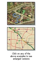
Rasterbilder wie Satellit- oder Luftfotografien direkt in Ihren
Landkarten verwenden. Diese Bilder können als Hinweise verwendet werden,
um geographische Karten herzustellen oder mittels der Editionstools zu
redigieren.
Daten
Zugang: TransCAD ermöglicht es, Landkarten mit Ihren eigenen
Daten herzustellen. Bilden Sie direkt Landkarten mit Daten von dBase und
Text Files oder greifen Sie zu Informationen von jeder kompatiblen ODBC
Datenquelle wie Access, Oracle, SQL Server usw. Sie können auch
Rasterbilder wie Satellit- oder Luftfotografien direkt in Ihren
Landkarten verwenden. Diese Bilder können als Hinweise verwendet werden,
um geographische Karten herzustellen oder mittels der Editionstools zu
redigieren.
Sie können ArcView Shapefiles, MapInfo TAB Files und räumliche Tabellen des Oracle direkt umwandeln. Mit den eingebauten Übersetzern können Sie geographische Daten vom anderen Desktop Diagramm, GIS, und CAD-Paketen importieren.
Georeferenzierung: Sie können Daten in der Landkarte lokalisieren, indem Sie die Adresse oder die Postleitzahl zu dem Datum hinzufügen oder wenn Sie direkt auf die Position in der Landkarte hinweisen. Mit wenigen einfachen Schritten können Sie Ihre eigenen Daten verwenden, um Postleitzahl-Codes beim Umsatz zu färben ( was bedeutet: Umsatzcodes färben?) oder die Positionen der Kunden anzuzeigen.
GPS: Eine eingebaute Schnittstelle zu den globalen Vorrichtungen der Navigationsanlage (GPS) lässt Sie Ihre Position aufspüren und notieren und errichtet geographische Datenbanken, während Sie arbeiten. Mit einem GPS und einem Laptop kann man auf dem Feld Landkarten herstellen mit der genauen Position von jedem interessierenden geographischem Punkt .
| File formats supported in TransCAD 5.0 | |||
| Map, GIS, and CAD formats |
Open
( |
Export | |
| AutoCAD Drawing Exchange format files (version R14 and earlier) | .DXF |
|
|
| Caliper Compact Data Format files | .CDF |
|
|
| Caliper Standard Data Format files | .DBD |
|
|
| Digital Elevation Model files (USGS, NOAA, DTED, Esri Binary) | .DEM;.G03;.G98; .DT0;.DT1;.DT2; .FLT |
|
- |
| Digital Line Graph format files (USGS, NWI, NATSGO, STATSGO, SURGO) | .DLG;.OPT;.STD;
.LGO;.LGS;.GRF; .0AF; .0SF;.ATT; .SYM |
|
- |
| Digitizing tablets | Wintab compliant drivers |
|
- |
| Esri ArcMap Document (requires ArcMap to be installed) | .MXD | - |
|
| Esri ArcView 3.x Project files and Legend Files | .APR; .AVL |
|
- |
| Esri Export format files | .E00 |
|
- |
| Esri Personal Geodatabase files | .MDB |
|
- |
| Esri Shapefiles | .SHP |
|
|
| Esri Ungenerate format files | .LIN;.PTS |
|
|
| ETAK MapBase format files | .MBS |
|
- |
| Google Keyhole Markup Language Files | .KML;.KMZ | - |
|
| GPS playback data files | .GPS |
|
|
| GPS device serial port | NMEA 0183 |
|
- |
| Intergraph Design files (ISFF or V7) | .DGN |
|
- |
| Interim Terrain Data (ITD) | .SLF |
|
- |
| MapInfo Interchange Format files | .MIF |
|
|
| MapInfo TAB files | .TAB |
|
- |
| Metadata (Federal Geographic Data Committee standard) | .MET |
|
|
| National Transportation Atlas Dataset (NTAD) format files | .PNT;.LNK;.NOD; .GEO; |
|
- |
| ODBC database with coordinates for points files | ODBC (SQL etc.) |
|
- |
| Oracle Version 7 (Spatial Data Option) files | SDO |
|
- |
| Oracle Version 8i (Oracle Spatial) files | SDO |
|
|
| Ordnance Survey NTF format files | .NTF |
|
- |
| Planning Interim Terrain Data (PITD) | .SLF |
|
- |
| Spatial Data Transfer Standard (SDTS) files | .DDF |
|
- |
| Strategic Mapping (Atlas) Boundary ASCII format files | .BNA |
|
|
| TIGER/Line files (TIGER 1990-2006, TIGER Compressed) | .F41;.F51;.F61; .BW1;.RT1;.ZIP; .TX1 |
|
- |
| U.S. Geological Survey Land Use and Land Cover (LULC) files | .GIR |
|
- |
| Vector Product Format (VPF) files |
|
- | |
| Image (raster) formats | Open | Export | |
| Bitmap (including True Color) | .BMP | - |
|
| Enhanced Compressed Wavelet | .ECW |
|
- |
| Enhanced metafile | .EMF | - |
|
| GeoTIFF | .TIF |
|
- |
| JPEG | .JPG;.JPEG |
|
|
| JPEG2000 | .JP2 |
|
- |
| MrSID (Multiresolution Seamless Image Database) | .SID |
|
- |
| MrSID Generation 3 | .SID |
|
- |
| Portable Network Graphics | .PNG | - |
|
| SPOT MetroView satellite images | .BIL;.TIF |
|
- |
| SPOTView satellite images | .BIL;.TIF |
|
- |
| TIFF | .TIF |
|
- |
| U.S.
Geological Survey digital rectified aerial photographs
(Digital Orthophotos, including Digital Orthophoto Quarter Quad image format |
DOQ;DOQQ |
|
- |
| Database/table/spreadsheet formats | Open | Export | |
| Caliper dataview | .DVW |
|
|
| Caliper fixed-format binary | .BIN |
|
|
| Comma-delimited text (read-only) | .CSV;.TXT |
|
|
| dBASE/FoxPro/X-base | .DBF |
|
|
| Fixed-format text | .ASC |
|
|
| HTML table | .HTM | - |
|
| Microsoft Access tables | .MDB;.ACCDB |
|
- |
| Microsoft Excel (Worksheet, XML, Binary, Macros) (read-only) | .XLS;.XLSX; .XLSB;.XLSM |
|
|
| ODBC SQL Query (ODBCQ) | ODBCQ |
|
- |
| ODBC table (ODBC) | ODBC (SQL,etc.) |
|
- |
| Oracle tables | .NTF |
|
- |
| Multimedia formats | |||
| Windows Media Video | .WMV |
|
|
|
Caliper Slideshows (Can include .WAV; .AVI; .MOV; .MPG;
.MPEG; .MP2; .MP3; .MPE; .ASF; .ASX; .WM; .WMA; .WMP; .WMX; .WMV; .WVX; .QT; .SND; .AU; .AIF) |
.SLI |
|
|
| Image Servers supported by TransCAD 5.0 | |||
| Google Earth satellite images | |||
| TerraServer-USA | |||
| ©2011 Caliper Corporation, All Rights Reserved |