|
|
| November 2011 |
|
|
Learn more about how Maptitude can help your organization: Marketing & Sales Mapping Software Precinct & Election Management |
|
|||||||||||
|
Featured Data
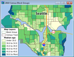
Product: 2010 U.S. Census Blocks Groups CD
The 2010 U.S. Census Blocks Groups CD is now available for the entire USA. The 2010 U.S. Census Block Groups Data CD is packed with information about the US population and is essential for making accurate location-based decisions. The product has been updated to reflect the latest 2010 boundaries and US data. The CD contains a nationwide area database with 220,180 Census Block Groups and 2010 Census demographic data. Block Groups are a combination of Census Blocks and are also a subdivision of Census Tracts. Block Groups generally contain between 600 and 3000 people and are made up of on average 40 Census Blocks. You will be able to answer questions such as "How many potential customers live within half a mile of my store?" or "In which location should we expand our market?" Included are 2010 Census counts for 147 fields that include total population, age, gender, race and ethnicity, and also total housing units broken down by whether they are vacant or occupied. Price: US$250. Place your order online at the Caliper Store. |
||||||||||||
|
Tech Tip:
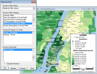
Using the Map Librarian to Map 2010 USA Demographic Data
Maptitude 6.0 provides a map library that contains pre-designed maps listed by USA Census category (see the training video). These include thematic maps of demographic, economic, and housing data by ZIP Code, Tract, County, and State. The Map Librarian lets you open one or more of these maps for a chosen location, allowing you to quickly analyze U.S. Census data for your area of interest. The following steps walk you through this task: 1. Choose Tools-Map Librarian, and make a choice from the Choose a Map Category list. 2. Choose one or more maps from the Choose the Map(s) You Want list (Ctrl- and Shift-clicking allow multiple choices). 3. Choose Other Location... from the Choose a Bookmark list, and click OK. Maptitude displays the Find tool. 4. Choose whether to display the chosen maps for an address, city, ZIP Code, county, or state from the scroll list and enter information about the chosen location in the edit boxes. 5. Click OK. Maptitude opens the maps you have selected at the location you chose using the Find tool. |
||||||||||||
|
Featured Maptitude Maps:
Idaho Congressional District Maps This month we showcase Idaho Congressional maps created with Maptitude Online Redistricting:
If you would like to see your maps showcased here, please contact Caliper. |