

NEWTON, MASSACHUSETTS (USA) - Caliper is pleased to announce that updated 2010 U.S. Census Blocks Groups Data is now available for the entire United States. The Census Block Groups Data is packed with information about the U.S. population and is essential for making accurate location-based decisions. The product has the latest 2010 boundaries and now includes 311 fields of demographic data from the 2011 American Community Survey (ACS) describing population, income, families, age, race, ethnicity, language spoken, housing units (age, rooms, bedrooms, tenure, heat, plumbing, kitchen), marital status, education, housing value, housing costs, rent, employment, workers, mode of commute, travel time, and vehicle availability. Also included are 97 fields of data from the 2010 Census describing population, age, gender, households, and housing units.
The product is provided on DVD or via download and contains a nationwide area database with 220,180 Census Block Groups. It works with the latest versions of Caliper's Maptitude mapping software and TransCAD transportation planning software.
The price is US$250 and it is available online at the Caliper Store.
Caliper Corporation develops state-of-the-art Geographic Information Systems (GIS) software. With a focus on usability, Maptitude is designed to be a cost-effective, professional mapping software product. Maptitude enables organizations to leverage their location-based data to improve decision making and planning, while minimizing expenditure through competitively priced solutions.
Caliper is a privately held corporation and is a leading developer of mapping, redistricting, transportation, and GIS software.
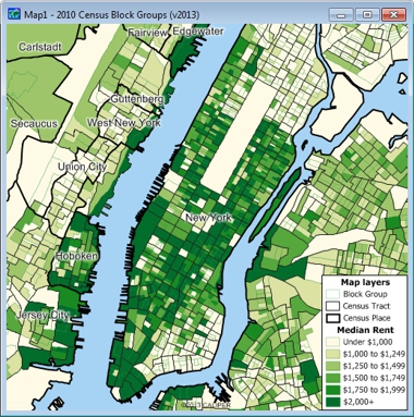
This color theme illustrates median rent by block group in New York. Block groups generally contain 600-3000 people. They are a subdivision of tracts, the most detailed Census summary level included with Maptitude and TransCAD.