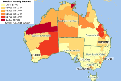
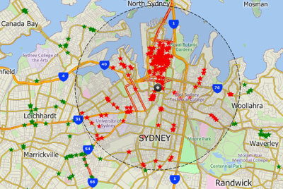
NEWTON, MASSACHUSETTS (USA) - Caliper is excited to announce an updated Australia Data Package! The product includes a wealth of data and functionality not available in any other software. The Australia data includes an updated street layer with address data for geocoding and travel time information for computing routes and travel-time rings. Also included are building footprints for many urban locations, railroads, and comprehensive named landmarks that range from public facilities to commercial buildings including shops, restaurants, and retail stores. An updated Local Government Areas layer based on 2013 boundaries is also included.
The Australia data is for use with Maptitude mapping software. Maptitude 2014, the latest release of Maptitude, combines several significant enhancements in productivity and high quality output. Finished reports are now accessible via a single click, allowing direct sharing of your geographic analysis. Map backgrounds can be seamlessly switched to show aerial photo-imagery or terrain, adding realistic and relatable elements to your presentations. Maps can now be visualized in a stunning and compelling 3D view. You can learn more about the new features in Maptitude 2014 by visiting the Caliper website.
Maptitude ships with one country of your choice (currently the U.S.A., Argentina, Australia, Brazil, Canada, Chile, Colombia, Ecuador, France, Germany, India, Ireland, Italy, Mexico, Netherlands, New Zealand, Peru , Portugal, South Africa, Spain, Switzerland, and United Kingdom), and additional packages can be purchased separately for US$595. You can switch between the countries you have purchased. Doing so refreshes the Maptitude interface with country-specific tools such as those for finding, pin mapping (geocoding), routing, and creating maps.
If you have any questions, please call Maptitude Sales (USA) at +1 617-527-4700, or send an e-mail to sales@caliper.com.
Caliper Corporation develops state-of-the-art Geographic Information Systems (GIS) software. With a focus on usability, Maptitude is designed to be a cost-effective, professional mapping software product. Maptitude enables organizations to leverage their location-based data to improve decision making and planning, while minimizing expenditure through competitively priced solutions.
Caliper is a privately held corporation and is a leading developer of mapping, redistricting, transportation, and GIS software.