How Can Members of the Public Contribute in the Redistricting Process?
A discussion of how public access can improve redistricting and how the public can contribute to the process.
How Can I Judge Redistricting Plans?
A discussion on how to best judge different district plans.
Why Is Redistricting Difficult?
An examination of the difficulties involved in redistricting.
What Is Gerrymandering?
An explanation of Gerrymandering and its origins.
What Are Some Principles That Are Important in Redistricting?
A list of important redistricting concepts and principles that help redistricters create fair district plans.
How Do I Navigate Redistricting Data?
An explanation of the different data available to redistricters and how they fit into the redistricting process.
How Do I Start Thinking About Redistricting in My Locality?
An introduction to how members of the public can contribute to the redistricting process.
Why Should We Care About Redistricting?
An argument for the importance of redistricting and how public access can improve the process.
What Is Redistricting?
A discussion of what Redistricting is, why it is important, and how to do it. A great starting point for any potential Redistricter.
How Do I Make my Maps Look Nice?
A good mapping software application or GIS (Geographic Information Systems) provides a library of default maps and styles out-of-the-box that allow you to create presentation-ready and professional looking maps. These predefined settings can help you rapidly create a useful map, but if you take a little more time, you can make some minor modifications that uncover the trends …
Why is My Data Package Not Listed in My Plan Manager?
Even after downloading your data package, it is possible that your data package is not listed in your plan manager. Before redownloading or reinstalling the data, you may want to check the default install location for Caliper data packages. E.g., C:/XX Data 2020 Final where XX is the state abbreviation. If that folder does not …
Why is My Data Package Not Listed in My Plan Manager? Read More »
What Fields Are Included in the 2020 Data?
Maptitude for Redistricting includes all of the 2020 Public Law 94-171 data fields in the 2020 geographic files. Field Description Population Total Persons White Race: White alone Black Race: Black or African American alone AmIndian Race: American Indian and Alaska Native alone Asian Race: Asian alone Hawaiian Race: Native Hawaiian and Other Pacific Islander alone …
How can I use a Communities of Interest layer with my plan?
How to use a Communities of Interest layer with your plan
Create a Template from a Plan
How to create a template from a plan backup
How do I find or restore lost windows and toolboxes?
How to find and restore lost windows and toolboxes
Working with Labels on Maptitude for Redistricting Maps
Modifying layer, feature display, and individual labels in a map.
How do I Lock One or More Columns in Place?
How to lock one or more columns in place.
What Geography is Included with Maptitude for Redistricting?
Data included with Maptitude for Redistricting
Filtering and Sorting Plans
Filtering and sorting plans in Maptitude for Redistricting.
Entering and Changing Redistricting Plan Settings
How to enter and change plan settings
Adding or Removing Districts from A Redistricting Plan
Adding and removing districts
Best Practices
Best practices for Maptitude for Redistricting
Glossary of Redistricting Terms
Glossary of Redistricting Terms
What Fields Are Included in the 2010 Data?
Data fields included with 2010 redistricting data
How Can I Change My Redistricting Tools to Select Features That Are Touching?
How to select features that are touching
Create a Template from a Plan Backup
How to create a template from a plan backup
What is Differential Privacy?
What is differential privacy
How Do I Backup or Restore a Plan?
How do I backup or restore a plan?
Should I Save a Map or Workspace for My Plan?
Should I save a map or workspace for my plan?
Where is My District Layer Stored?
Where is my district layer stored?
What Files are Created with A Redistricting Plan
Files that are created with a redistricting plan
What Method is used in the Ensemble Analysis?
What method is used for the ensemble analysis?
How Do I Get Updated Voting District Boundaries?
How do I get updated voting district boundaries
How Can I Move My Pending Changes Toolbox if the Title Bar is Off Screen?
How Can I Move My Pending Changes Toolbox if the Title Bar is Off Screen?
Getting Started with Maptitude for Redistricting
Getting Started with Maptitude for Redistricting
Redistricting Desktop vs. Maptitude for Online Redistricting Feature By Feature
Maptitude for Redistricting and MORe feature by feature comparison
Redistricting Desktop vs. Maptitude for Online Redistricting
Comparison of Maptitude for Redistricting desktop and Maptitude for Online Redistricting
Importing a Plan Using an Equivalency File
Importing a Plan Using an Equivalency File
When Will I Receive My 2020 Redistricting Data?
2020 Redistricting Data
Maptitude Online Redistricting Technical Specifications, Requirements and Licensing Information
Maptitude Online Redistricting
Technical Specifications, Requirements and Licensing Information
Maptitude for Redistricting Hardware Recommendations
MTR Hardware Recommendation
Where do I find an example of Maptitude for Online Redistricting (MORe)?
Where do I find an example of Maptitude for Online Redistricting (MORe)
How Do I Export a Plan to an Equivalency File?
You can export a redistricting plan at any stage of development and the map features can be from the base layer or any layer that aggregates to features in the base layer. In most cases you will export to blocks. Choose Redistricting>Plan Utilities>Export Plan. Choose the selection of districts to export from the District drop-down …
Can I create redistricting plans on the Internet or my intranet?
Yes. Maptitude for Online Redistricting (MORe) is a web-based redistricting software designed to draw and report . The is similar to the toolbox in the desktop version, and the user can zoom, pan, and query the map using the mapping tools. The tool can be used in any browser window without the need for the …
Can I create redistricting plans on the Internet or my intranet? Read More »
Can I shade my districts so they stand out on my map?
Maptitude for Redistricting includes a custom file in your redistricting region folder. You can use this file to shade your districts. Right-click on the Districts layer in the Display Manager and choose Make working layer. Click to open the Color Theme Map Wizard. Click Load… Choose the From Settings File radio button. Browse to C:\XX Data 20YY Final …
Can I shade my districts so they stand out on my map? Read More »
Can I Open a Plan of Enacted Districts?
Maptitude for Redistricting includes a library of enacted plans and templates for the geographic area included with your purchase. To get started, click the Libraries tab in the plan manager. In the Libraries tab, click Add. Browse to the location on the C drive where your redistricting data was installed. This is usually named with …
Can multiple users share the same geographic file over a network?
Multiple users can share compact geographic files (.cdf extension) over a network in a read-only folder. If the geographic file is a standard geographic file (.dbd extension), you should export it to a compact geographic file using File>Export>Geographic File.
Can I have null values in the control field?
The control field must at least contain 0s (zeros).
Can I use a dummy variable for the control field if I don’t care about control field values?
Can I use a dummy variable for the control field if I don’t care about control field values?
How do I use a Subset of Geography in a Redistricting Plan?
How to use a Subset of Geography in a Redistricting Plan
How Can I Display the Plan Components Report With Shortened Tract Or Block Numbers?
Using shortened block or tract numbers in the Plan Components Report is very easy. All you have to do is create a formula field (which you call Name) that contains the information you want displayed. For example, to show the block group and block number of a block (the last 6 digits of the 15-16 …
How Can I Display the Plan Components Report With Shortened Tract Or Block Numbers? Read More »
How Can I Create Labels That Span Multiple Lines? (Multi-line Labels)
Formulas can be used to make labels with multiple lines like in the following example: There are a few things to remember when creating multiple line labels: Any text strings should be contained in quotes. In the example above, the words “Tot. Pop.: ” are in quotes. All numeric values should be converted to text …
How Can I Create Labels That Span Multiple Lines? (Multi-line Labels) Read More »
How Do I Create a Formula Field and Add It to My Summary Fields?
To add custom formula fields to your plans, you can add your formula fields to the maps your plans are based on (typically Block-VTD-County.Map or Block-Block Group-Tract-County.Map). You can follow the steps below to add custom formula fields to a map. Open the map you want to add a formula field to by doing File>Open, selecting …
How Do I Create a Formula Field and Add It to My Summary Fields? Read More »
How are Prisoners Addressed in 2020 Redistricting Data?
How prisoners are counted
What are Group Quarters?
Explanation of 2020 Census group quarters definitions
How Do I Create a New Template Based on a Previous Template?
Creating a new template using a template createed with previous geography
How Do I Create a New Plan Based on Previous Geography?
Creating a new plan using previous geography
How can I create a list of features that have not been assigned in my plan?
It is useful to identify which unassigned features contain population so that you can easily review them in your plan. To do this, follow these steps: Choose Redistricting>Plan Utilities>Export Plan Choose All Districts from the District dropdown Check “Export as Layer Hierarchy Components” Click OK Enter a filename and click Save The resulting file contains …
How can I create a list of features that have not been assigned in my plan? Read More »
How do I customize the style for layers that are using Feature Display?
How to work with a layer that has Feature Display settings applied
Working with Data in Maptitude for Redistricting
Using the Info tool, displaying data in a dataview, and working with dataviews
How Do Create New Labels for Precincts in My Map?
Customizing data for labels
Using Field Sets
How to use field sets
How Do I Incorporate Block Level Data into Other Layers?
How to incorporate block level data into all layers
How Can I Determine the Total Miles of Roadway in a District?
How to display the mileage of streets in a district.
How Can I Use My Own Layer to Select Features While Redistricting?
Using custom geography for selecting features
How to Use Incumbent Information in a Plan
How to Use Incumbent Information in a Plan
How do I automatically map incumbents using the locate tools?
How do I add incumbents to the map
How Do I Incorporate ACS Data into My Plans?
How to incorporate ACS and CVAP data into plans.
How Do I Restrict My Redistricting to a Subset of a Geographic Area?
Restrict redistricting to a geographic area
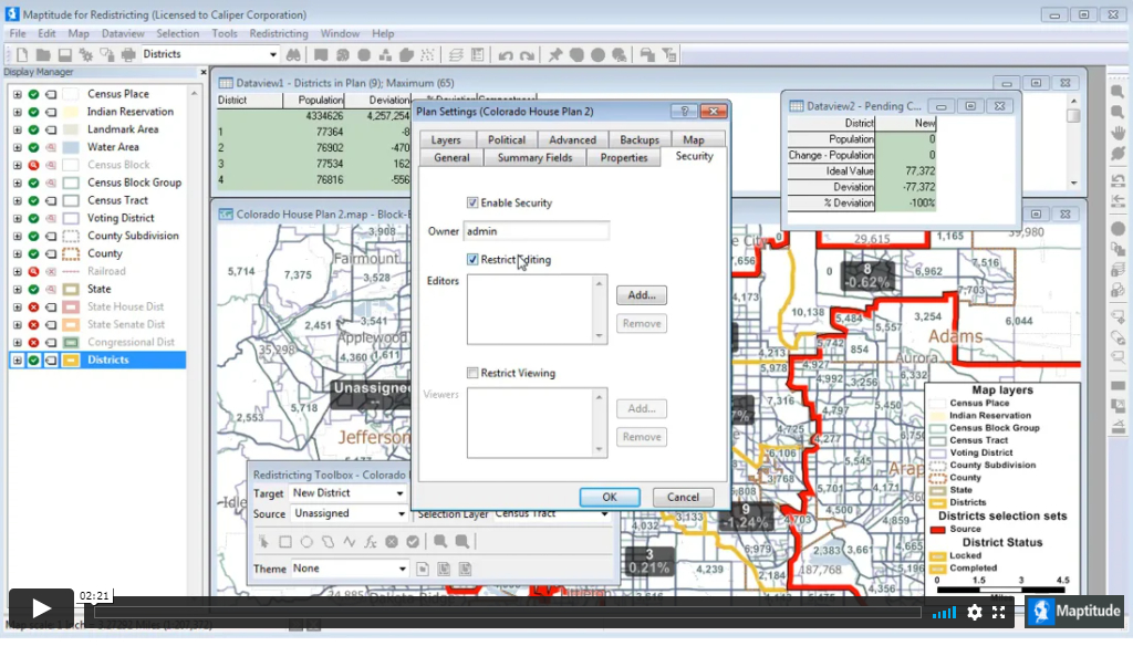
Plan Security
How to secure a Maptitude for Redistricting plan library and specify which users have editing and viewing rights to each plan
How do I use Communities of Interest?
You can identify a community of interest by creating a named selection set using the standard Maptitude selection tools.
How can I create a theme that shows the predominant race/ethnicity in each feature?
Create a theme that shows the predominant race/ethnicity in each feature.
How do I merge subplans?
You can merge sub plans for different geographic areas into an open plan.
How do I create a plan with current political districts?
If you already have an , you can import that file during the creation process to rebuild the plan in Maptitude for Redistricting. Choose Redistricting>Plan Manager to display the Plan Manager dialog box. Choose a library for the new plan from the Library drop-down list. Click New to display the New Plan wizard. Click the …
How do I create a plan with current political districts? Read More »