You can show postal sector and district boundaries for the Channel Islands, Isle of Man, Northern Ireland, and the Republic of Ireland with UK postcode mapping software.
If you are mapping using the United Kingdom country package, you may have noticed that the Postcode Sector and/or Postcode District boundaries for the Channel Islands, Isle of Man, Northern Ireland, and The Republic of Ireland are not present by default.
Maptitude has additional postal boundary data for visualization, but the data cannot be exported for use outside of Maptitude. This includes:
- Postal Sector boundaries for Northern Ireland, the Isle of Man, and the Channel Islands (Guernsey, Jersey, and Alderney)
- 3-digit Eircode Routing Key boundaries for Ireland
- The Ireland Eircode boundaries are only present in the UK Postcode Sector layer
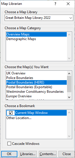
These postal boundaries can be accessed by going to Map>Demographic Map Librarian and choosing the below options:
These layers are not available by default in the Maptitude Create-a-Map Wizard.
- To thematically map your data to these boundaries you will need to first join your data tables. For help with joins, please try the Maptitude tutorial article on dataview joins
- To use the boundaries with the territory tools, first make the above map the working Maptitude window, and then choose Map>New Territory Layer. For help with creating territories, please try Maptitude tutorial video on creating territories
If you want to locate (geocode) your data using the Northern Ireland postcodes, please try Maptitude tutorial article on locating with postcodes.
- To change the style and label settings for the postal layers, please try Maptitude tutorial video on the Display Manager.
- To visualize the demographic data included with the postal layers, please try Maptitude tutorial video on thematic mapping.