Maptitude Help / Managing Geographic Files / Creating and Using Metadata
Creating and Using Metadata for a Geographic File
Metadata are data about data. Maptitude lets you view, create, and edit metadata associated with geographic files. The metadata are stored in a file with the same name as the geographic file and the extension .met. The file contains text that can be viewed with any text editor, or with the Metadata Viewer, which lets you create, edit, and view metadata. You can display the Metadata Viewer from the Layers dialog box or from the Geographic File dialog box.
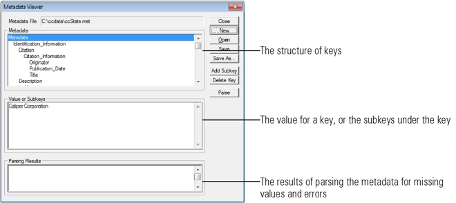
The metadata are structured using the Federal Geographic Data Committee (FGDC) Standard. For more information, see Content Standard for Digital Geospatial Metadata, Publication FGDC-STD-001-1998, available on the FGDC website (www.fgdc.gov). The structure has keys, subkeys, and values. Each key either has a value or has one or more subkeys. The subkeys themselves are keys which can have values or subkeys.
The root key is Metadata, and it can have up to seven predefined subkeys:
- Identification_Information
- Data_Quality_Information
- Spatial_Data_Organization_Information
- Spatial_Reference_Information
- Entity_and_Attribute_Information
- Distribution_Information
- Metadata_Reference_Information
In turn, the Identification_Information key can have up to 14 predefined subkeys, such as Originators. Some subkeys can be repeated if there are multiple values, such as two Originators. Notice that keys have no spaces in their names.
There is a minimum set of values that are recommended in the FGDC metadata standard. If a geographic file does not have a metadata file, Maptitude will help you create it from scratch, from a template, or from the geographic file itself. Any Maptitude metadata file can be used as a template for creating a new metadata file.
After you add subkeys, delete keys, and edit values, Maptitude can parse your metadata to see if there are missing values or errors.
Viewing Metadata for a Geographic File
Maptitude displays metadata in the Metadata Viewer dialog box, which you can open from the Layers dialog box, using the Map>Layers command, or from the Geographic File dialog box, using the Tools>Editing>Layer Manager command. Since the metadata file only contains ASCII text, it can also be viewed with any text editor or other program that can display a text file.
With the Metadata Viewer you can browse the keys and their subkeys or values. When you highlight a key that has one or more subkeys, the subkeys are listed in the Value or Subkey scrolling edit box. When you highlight a key that has a value, the value is shown in that scrolling edit box.
 To View Metadata for a Geographic File
- Choose the layer whose metadata you want to see from the drop-down list on the Standard toolbar.
- Choose Map>Layers, click
 on the Standard toolbar, or right-click on the map and choose Layers to display the Layers dialog box. The chosen layer will be highlighted.
— OR —
Choose Tools>Editing>Layer Manager to display the Geographic File dialog box. The chosen layer will be shown in the Layer drop-down list.
- Click Metadata to display the Metadata Viewer dialog box. The file name for the metadata file is shown in the Metadata File text box. If the layer does not have metadata, <No File> will be shown in the Metadata File text box.
 |
TIP: You can also open the Metadata Viewer dialog box by right-clicking on a layer in the Display Manager and choosing Metadata. |
- Highlight a key in the Metadata scroll list. Maptitude displays either the subkeys or the value for that key.
- Return to Step 4 to display other subkeys or values.
- Click Close to return to the Layers or Geographic File dialog box.
- Click Close to close the Layers or Geographic File dialog box.
Creating Metadata for a Geographic File
You can create a new metadata file from scratch. Maptitude knows the rules for building metadata using the FGDC standard, and will assist you with lists of the valid subkeys for a key, including those that can and cannot be repeated. Maptitude can also assist you in two ways, by:
- Opening an existing metadata file to use as a template for creating the new metadata file
- Scanning the geographic file to get values such as the bounding coordinates
If you combine these two ways, Maptitude makes it much easier to document a set of files with similar metadata values. You can always add additional subkeys and values to meet the particular needs of a geographic file.
Any metadata file can be used as a template. You can also prepare a metadata template file by removing values that will be filled in for a specific geographic file, such as bounding coordinates, or subkeys that will be added for a specific geographic file, such as the Detailed_Description subkey under the Entity_and_Attribute_Information key. Then you can use both the template and the geographic file as sources of metadata to fill in most of the values.
When Maptitude scans a geographic file to get values, it tries to fill in the following values:
| Under key... | Values for subkeys... |
|---|---|
| Identification_Information\Citation\Citation_Information | Title |
| Identification_Information\Spatial_Domain\Bounding_Coordinates | West_Bounding_Coordinate, East_Bounding_Coordinate, North_Bounding_Coordinate, South_Bounding_Coordinate |
| Spatial_Reference_Information\Horizontal_Coordinate_System_Definition\Geographic | Latitude_Resolution, Longitude_Resolution, Geographic_Coordinate_Units |
| Entity_and_Attribute_Information\Detailed_Description | Entity_Type subkeys plus one set of Attribute subkeys for each field |
To Create Metadata for a Geographic File
- Choose the layer whose metadata you want to create from the drop-down list on the Standard toolbar.
- Choose Map>Layers, click on the Standard toolbar, or right-click on the map and choose Layers to display the Layers dialog box. The chosen layer will be highlighted.
— OR —
Choose Tools>Editing>Layer Manager to display the Geographic File dialog box. The chosen layer will be shown in the Layer drop-down list.
- Click Metadata to display the Metadata Viewer dialog box. If the layer already has metadata, the file name will be shown in the Metadata File text box.
- Click New to display the Create a New Metadata File dialog box.
- Make choices as follows:
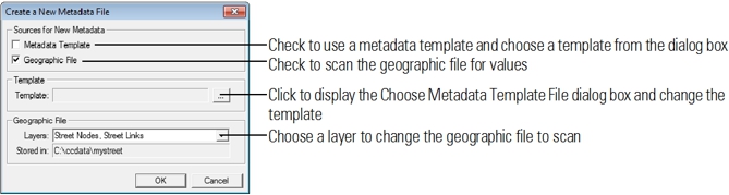
- Click OK. Maptitude creates the new metadata file, parses it, and shows the results in the Parsing Results scroll list
- Click Close to return to the Layers or Geographic File dialog box.
- Click Close to close the Layers or Geographic File dialog box.
Editing Metadata for a Geographic File
You can edit an existing metadata file by adding subkeys, deleting keys, and editing values. You can also check to see if the metadata meet the FGDC standard by parsing the metadata to look for errors. Some subkeys can be repeated, so that you can have multiple values; Maptitude will only let you add more than one copy of subkeys that can be repeated. You can only delete a key if it does not have subkeys under it.
You can edit a metadata file to use it as a template, and save it as a new metadata template file.
To Edit Metadata for a Geographic File
- Choose the layer whose metadata you want to edit from the drop-down list on the Standard toolbar.
- Choose Map>Layers, click on the Standard toolbar, or right-click on the map and choose Layers to display the Layers dialog box. The chosen layer will be highlighted.
— OR —
Choose Tools>Editing>Layer Manager to display the Geographic File dialog box. The chosen layer will be shown in the Layer drop-down list.
- Click Metadata to display the Metadata Viewer dialog box. The file name for the metadata file is shown in the Metadata File text box. If the layer does not have metadata, <No File> will be shown in the Metadata File text box.
- Make choices as follows:
| To do this... | Do this... |
|---|---|
| Add a subkey | Highlight the key to which you are adding a new subkey in the Metadata scroll list, then click Add Subkey to display the Add Subkey dialog box. Choose a subkey from the Subkey drop-down list and click OK. |
| Delete a key | Highlight the key to delete in the Metadata scroll list, then click Delete Key to display a Confirm dialog box. Click Yes to delete the key or No to keep the key. Maptitude will display a message if the key still has subkeys under it and cannot be deleted. |
| Parse the metadata for errors | Click Parse. Maptitude parses the metadata and shows the results in the Parsing Results scroll list. |
| Edit a value | Highlight a key with a value in the Metadata scroll list, and edit the value in the Value or Subkeys scroll list. |
| Save the changes | Click Save. |
| Save the changes to a new file | Click Save As to display the Save Metadata File As dialog box. Choose the drive and folder, type the file name and click Save. |
| Open a different metadata file | Click Open to display the Open a Metadata File dialog box. Choose the metadata file and click Open. |
©2026 Caliper Corporation