Maptitude Help / Managing Geographic Files / Merging Geographic Files
Merging Geographic Files
You can merge features in the working layer and another layer into a new standard (.dbd) geographic file. The other layer can be any layer in any map with the same feature type (point, line, or area) as the working layer. For example, two people could work on two adjacent map sheets and then merge their geographic files with the Tools>Editing>Merge Layers command. Duplicate or similar map features are handled as follows:
| Type of layer | Action |
|---|---|
| Point | If two features have the same coordinate, you can choose to merge them or to leave them as two separate features. |
| Line | If two features have the same endpoints and shape points, they will remain two separate features. If endpoints in either layer have the same coordinate, you can choose to merge them or to leave them separate. |
| Area | If two features have the same boundary, the feature in the other layer is ignored. If two features overlap, you can choose to add the overlapping areas to the area in the working layer or to create new areas from the overlapping areas |
When you merge geographic files you will also be merging the data associated with the files. Maptitude will suggest how to match up the fields in the other layer to the fields in the working layer based on their names and types. You can choose the field in the other layer to match with a field in the working layer based on their names and types. You can use the Dataview>Table>Modify command first to add fields to the working layer to accommodate data from the other layer.
You can choose whether to copy the numeric values in an area working layer or to split them when areas of overlap are not merged into the working layer. You can merge node attributes for line layers that have a node layer.
If you need to preserve the IDs of features in the working layer, such as for joining tables based on those IDs, you can copy the IDs from the working layer into an existing or a new integer field.
 To Merge Geographic Files
- Open two geographic files of the same type as layers in one or more maps. If you want to merge just selected features, create a selection set in either or both layers.
- Choose the working layer from the drop-down list on the Standard toolbar.
- Choose Tools>Editing>Merge Layers to display the Merge Layers dialog box.
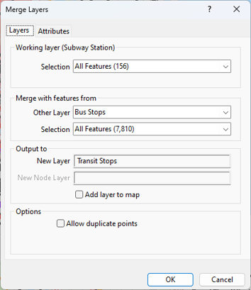
- Choose whether to merge all features in the working layer or a selection set from the Selection drop-down list.
- In the Merge with features from frame, choose the other layer to use and which features from the drop-down lists.
- Enter a name for the new layer in the New Layer edit box. If you are merging line layers, also enter a name for the new node layer in the New Node Layer edit box.
- Check the Add layer to map box to add the merged layer to the active map.
- Choose how to handle duplicate or similar map features:
| To do this... | Do this... |
|---|---|
| Merge points with the same coordinate | Remove the check from Allow Duplicate Points box |
| Keep points separate | Check the Allow Duplicate Points box |
| Merge endpoints with the same coordinate | Check the Merge Endpoints at Matching Locations box |
| Keep endpoints separate | Remove the check from the Merge Endpoints at Matching Locations box |
| Merge overlaps into working layer areas | Check the Merge Overlapping Areas into Working Layer box |
| Create new areas from areas of overlap | Remove the check from the Merge Overlapping Areas into Working Layer box |
If you are merging area layers, you can copy the IDs from the working layer into the new layer. Make a choice from the Preserve IDs In drop-down list:
| To do this... | Do this... |
|---|---|
| Copy the IDs to an existing integer field | Choose the integer field from the drop-down list |
| Copy the IDs to a new field | Choose <New Field> near the top of the drop-down list |
| Not preserve the IDs | Choose <None> at the top of the drop-down list |
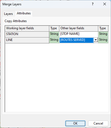
For each field in the working layer, choose a matching field from the other layer as follows:
| To do this... | Do this... |
|---|---|
| Change the other layer field | Choose a field from the respective drop-down list in the Other layer fields column |
| Indicate that there is no equivalent field | Choose -- from the respective drop-down list in the Other layer fields column |
| Split numeric values for area layers | Check the Split Working Layer Value box. The checkbox is disabled when the Merge Overlapping Areas into Working Layer option is checked |
- If you are merging line layers, click the Node Attributes tab to display the node attribute settings. This tab will not be enabled if one or both line layers do not have a node layer, such as with Oracle layers.
Make any necessary changes to the matching fields:
| To do this... | Do this... |
|---|---|
| Change the other layer field | Choose a field from the respective drop-down list in the Other layer fields column |
| Indicate that there is no equivalent field | Choose -- from the respective drop-down list in the Other layer fields column |
- Click OK.
Maptitude creates the new geographic file.
©2026 Caliper Corporation