![]()
![]()
![]()
![]()
![]()
![]()
![]()
With the Esri™ software being retired, now is the perfect time to consider Maptitude as you look for an Esri ArcMap replacement. Maptitude is an affordably priced, intuitive, but powerful GIS that comes packed with data and has both desktop and online applications, and desktop-to-web map publishing. In addition, Maptitude has extensive support for the Esri file formats including native File Geodatabase support and import.
There are many benefits when you use Maptitude as an alternative to Esri software:
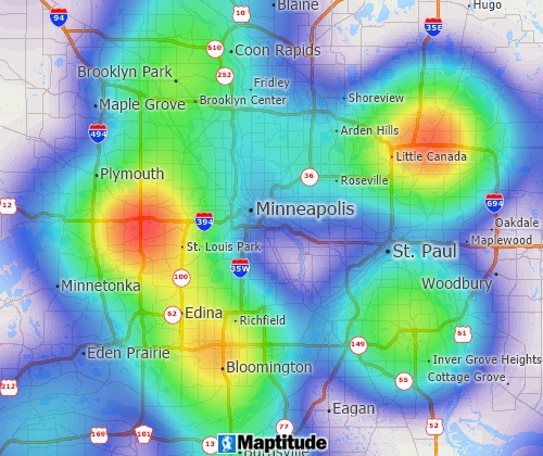
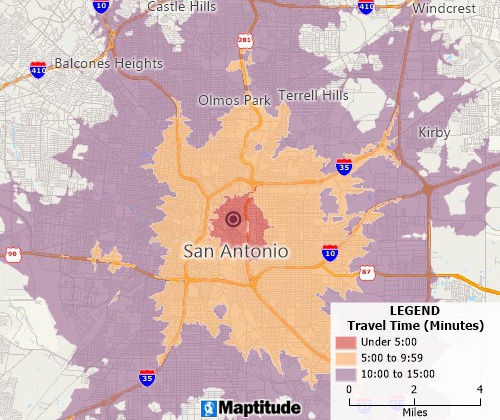
The Maptitude Esri replacement and ArcMap alternative includes street-level data for a country of your choice, as well as many analysis tools including density heat maps, drive-time rings, territories, and more.

|
“Maptitude is better than ArcGIS Business Analyst for most of what I need. It is easy to create and export Excel files that contain lists of data points, and the associated information, within polygons. Another benefit is that the learning curve is not steep (and the help documentation is excellent).”
|
 |
“Maptitude is a great GIS program that is infinitely easier to use than ArcGIS. I am a novice at GIS software, and I have access to both ArcGIS and Maptitude. Maptitude is significantly easier to use. ArcGIS is a very powerful sophisticated program, but it would take me weeks to learn to do some things that Maptitude does intuitively.”
|
| Maptitude | ArcGIS 10.2 | |
|---|---|---|
| Single User License (Standard) | $695 | $7,000* |
| Annual Licensing | $0 | $3,000* |
| Data Included (HERE streets) | Country Package of your choice included in the $695 price | Ask for quote |
| State, County, ZIP Code, and Tract Level U.S. Census data | Included with Country Package | Ask for quote |
| Network Analyst: shortest routes, drive-time rings, service area definition, flow lines, and network/territory creation | Included with Maptitude | $2,500 (add-on extension) |
| Spatial Analyst: rings (bands/buffers), hot spots, areas of influence, weighted polygons, statistical analysis | Included with Maptitude | $2,500 (add-on extension) |
| Business Analyst: demographic reports, demographic data analysis, lifestyle segmentation | Included with Maptitude (business data and lifestyle segmentation not included) | $2,500 (add-on extension) |
| 3D Analyst: 3D mapping and surface analysis | Included with Maptitude | $2,500 (add-on extension) |
*As of 8/29/2017 according to https://store.esri.com/content/esri/en-us/arcGISDesktop/arcgis-desktop-standard.html

|
“In 2013, my company made a decision to move from ArcView to Maptitude because of ESRI's annual licensing fees and the high expense for their extensions. At first, my GIS analyst was concerned about such a sudden change, but he was able to get proficient in only about a week. My firm serves school districts around the country, providing maps and demographic data to help with enrollment planning. Since changing to Maptitude, several clients have commented that the maps are easier to read, and provide more information than we used to be able to provide under ArcView. It was a good move. I just wish I had done it sooner.” Preston Smith |
 |
“It offers almost all functionality available in the standard versions of MapInfo and ArcView. Maptitude has a stable database engine that can read and write data from most commercially available software. In fact, Maptitude can read GIS maps developed in MapInfo and ArcView proprietary formats without the need of first converting those maps into Maptitude format.”
|
Maptitude is the perfect solution for adding additional GIS users where Esri software is already in use. Maptitude:
ArcView was a Geographic Information System (GIS) software developed by Esri, widely used for mapping and spatial analysis. It provided a user-friendly interface for professionals and enthusiasts to create, analyze, and visualize geographic data. Unfortunately, ArcView has been discontinued by Esri, leaving users in search of a suitable replacement. It was replaced by a new product line, ArcGIS, in 2000. The last release of ArcView GIS was version 3.3 (May 22, 2002).
Maptitude is a powerful ArcView alternative that has gained recognition for its robust features and versatility in the realm of GIS. Maptitude is a comprehensive GIS software developed by Caliper Corporation, designed to meet the mapping and spatial analysis needs of users across various industries.
One of the key reasons why Maptitude is considered the best replacement for ArcView is its user-friendly interface. Maptitude is known for its intuitive design, making it accessible to both GIS experts and those new to the field. The software's ease of use ensures a smooth transition for former ArcView users who are familiar with a similar straightforward approach.
Maptitude also boasts a wide range of advanced features, ensuring that users can perform complex spatial analyses and create visually compelling maps. From demographic analysis to route optimization, Maptitude covers a diverse set of applications, catering to the needs of professionals in fields such as sales territory planning, marketing, logistics, and more.
Additionally, Maptitude offers extensive data compatibility, allowing users to import and export data in various formats seamlessly. This flexibility ensures that users can work with data from different sources and integrate it into their GIS projects without any hassle.
The maintenance provided with Maptitude further enhances the appeal of the product. Users can rely on timely updates and a responsive support team to address any queries or issues they may encounter during their GIS projects.
While ArcView may be a thing of the past, Maptitude emerges as a worthy successor, offering a user-friendly experience, advanced features, and excellent support. For individuals and organizations seeking a reliable GIS solution, Maptitude stands out as the best replacement for ArcView, ensuring a smooth and efficient mapping and spatial analysis experience.
As ArcMap's retirement date approaches on March 1, 2026, many users are searching for a capable successor. While Esri offers alternative solutions within the ArcGIS platform, Maptitude emerges as a powerful and user-friendly option specifically designed for seamless migration from ArcMap.
Maptitude boasts several key strengths that make it an ideal replacement for ArcMap:
 |
“Maptitude is an excellent GIS program and is priced very low considering the value it provides. To name just a few key benefits I've experienced after owning it for only a week: It has tons of geographic and demographic information; it's relatively easy for beginners; there are tons of online guides, training materials, and seminars; tech support is very responsive and helpful. I highly recommend this program to anyone looking for basic to complex functionality in a GIS program.”
|
Maptitude goes beyond simply replicating ArcMap's functionalities. It offers several unique advantages:
Migrating from ArcMap to Maptitude is remarkably straightforward. Caliper offers file import tools that seamlessly transfer your existing data, minimizing disruption and maximizing efficiency.
While the end of ArcMap may seem daunting, it presents an opportunity to explore new horizons. Maptitude stands as a powerful and user-friendly alternative, offering a familiar yet innovative platform for your GIS needs.
Ready to make the switch? Download a free trial of Maptitude and experience the future of GIS for yourself. With its intuitive interface, comprehensive features, and commitment to user success, Maptitude is poised to become your trusted partner in navigating the exciting world of geospatial analysis.
 |
“As
a user of Maptitude for the past 10 years, I can say that I
have been continually impressed at the improvements that
have been made through each iteration of the software. I use
the software primarily for business/retail applications,
institutional research, and logistics. Maptitude's greatest
strength is the software’s ability to crunch through “big
data” sets and display that data spatially in just a few
steps. Maptitude is a great alternative to ArcMap,
as all of the ArcMap extensions (i.e. spatial analyst,
network analyst, etc.) are all built-in for a fraction of
the cost.
|
ArcGIS Insights is a powerful data analytics tool, but it can be expensive and complex to use. Maptitude is a more affordable and user-friendly alternative that offers many of the same features, plus some unique advantages.
Maptitude excels in providing and visualizing up-to-date location-based business data, allowing organizations to use location intelligence to analyze how geography impacts their operations.

The intuitive and user-friendly Maptitude interface makes spatial analysis accessible to users of all skill levels. Say goodbye to steep learning curves: Maptitude has a straightforward wizard-driven design that ensures that you can harness the power of spatial analytics without the hassle.
While ArcGIS Insights may offer a range of features, Maptitude takes it to the next level. From advanced mapping capabilities to comprehensive spatial analysis tools, Maptitude equips you with everything you need to turn your data into actionable insights. With Maptitude, you're not just analyzing data; you're unleashing its full potential.
 |
“I've been using Maptitude for more than 15 years. It is simply the best tool available for businesses that need a market planning mapping and data resource. It can do everything I need it to do - from the very simple to the complex. It integrates nicely with other programs and file types making analysis and presentation very easy. I highly recommend Maptitude to firms who need a function-rich GIS mapping solution. It is the best!”
|
Budget constraints shouldn't limit your access to cutting-edge spatial analytics. Maptitude offers a cost-effective alternative to ArcGIS Insights without compromising on functionality. Experience the same level of sophistication without breaking the bank, making Maptitude the smart choice for organizations of all sizes.
Maptitude has flexible purchase options that include zero subscription fees with secure off-line data storage to Software as a Service subscriptions.
Maptitude is well known for its maturity, stability, and robustness. Maptitude boasts superior performance, ensuring that you can handle large datasets and complex analyses with ease. Don't let sluggish software hinder your progress: The efficiency of Maptitude sets it apart, allowing you to focus on what matters most: extracting meaningful insights from your spatial data.
 |
“They
continually outpace the industry with customer support and
provide it in a timely manner. If you are looking for a
premier organization that provides cutting edge product and
service, Caliper is the company to call.
|
Whether your work spans local communities or global landscapes, Maptitude provides the tools you need to navigate the world of spatial analytics. With extensive geographic coverage and support for a wide range of data formats, Maptitude is your passport to a truly global perspective.
Analyze your data or the included demographic data provided with the United States, Australia, Brazil, Canada, France, Germany, Italy, Mexico, New Zealand, and United Kingdom Country Packages.
The Maptitude Team's commitment to customer success is evident in its exceptional support services and positive reviews. The Maptitude Team is passionate about spatial analytics, ensuring that you can rest easy knowing that help is just a click away.
In the realm of spatial analytics, Maptitude emerges as the superior alternative to ArcGIS Insights. From its user-friendly interface to its unmatched performance, Maptitude empowers you to unlock the full potential of your geographic data without breaking the bank. Make the switch today and elevate your spatial analytics game with Maptitude.
 |
“Maptitude provides great details of geographies along with demographics and economic variables at all the hierarchies we need. It is the best mapping tool we have and is so much better than some of the big data software packages we have used. We use maps from Maptitude for our reporting and analytics and clients are excited about how much detail we can give them. Maptitude has much more analytical capabilities and the maps are much more detailed. We have been using Maptitude to show retailers, dealers, and manufacturers their Total Available Markets based on our product forecasts. Once we load our forecasts, dealer locations, housing starts and other demographics, we are able to show where potential new business can be won. Maptitude has allowed us to better display our insights beyond the usual charts and tables.”
|
Maptitude desktop and Online:
A Strong Contender for Sharing Data in ESRI Formats to Online Maps
While ArcGIS Online is a popular platform for online mapping and data sharing, Maptitude desktop and Maptitude Online offer a compelling alternative, especially when it comes to working with data in ESRI formats. Here's why:
Affordability: Maptitude desktop offers a one-time purchase model that grants you unlimited access to the software. This contrasts with ArcGIS Online's subscription-based model, which can incur ongoing costs over time. Additionally, Maptitude Online operates as a separate subscription service, allowing you to choose the level of online functionality you need without requiring the full ArcGIS licensing commitment.
| Maptitude | ArcGIS Online (5 users) | |
|---|---|---|
| Annual licensing | $695 | $2,500 |
| Data storage, analytics, demographics, and lifestyle maps | Free – Included with Maptitude | Available using service credits at 10 per $1 |
| State, county, and tract level U.S. Census data | Free – Included with U.S. Country Package | 10 credits per 1,000 map requests |
| Infographics | Free – Included with Maptitude | 10 credits per 1,000 views |
| Geocoding | Free – Unlimited locations | 40 credits per 1,000 geocodes |
| Drive time and routing: shortest routes, drive-time rings, service area definition | Free – Included with Maptitude | 0.04 credits per simple route, 0.5 credits per optimized route, 0.5 credits per closest facilities route |
| Map layers with over 1,000 records/features | Yes, Unlimited | Limited when adding* |
As of 9/07/2018 according to https://store.esri.com/content/esri/en-us/arcgis_online/arcgis-online-named-users.html
*https://support.esri.com/technical-article/000012039
Data Compatibility: Unlike some online mapping platforms that have limited support for non-native formats, Maptitude seamlessly integrates with ESRI data formats like shapefiles and geodatabases. This allows you to directly import and work with your existing ArcGIS data in Maptitude without conversion hassles. This can be a significant advantage if your workflow or data analysis already heavily relies on ESRI formats.
Advanced Analytics and Optimization: Maptitude desktop surpasses most online mapping platforms when it comes to advanced geospatial analysis and optimization tools. It offers functionalities like network analysis, route planning, territory management, and spatial statistics, enabling you to extract deeper insights from your data and make data-driven decisions. Many of these features are unavailable or require additional extensions in ArcGIS Online.
Sharing and Collaboration: Both Maptitude desktop and Online offer flexible options for sharing your GIS data and maps. You can:
Ease of Use: Both Maptitude desktop and Online are known for their user-friendly interface, making them accessible even for users with limited GIS experience. The intuitive layout and streamlined workflows allow you to quickly create maps, analyze data, and share your findings.
Additional Advantages: Maptitude offers some additional features that can be advantageous depending on your needs, such as:
There are many benefits when you use Maptitude desktop as an alternative to ArcGIS Online™:
Maptitude desktop and Online present a compelling alternative to ArcGIS Online, especially when it comes to sharing data in ESRI formats and conducting advanced spatial analysis. Its affordability, data compatibility, powerful analytic tools, user-friendly interface, and flexible sharing options make it a strong choice for individuals and organizations looking for a robust and cost-effective platform for online mapping and GIS workflows.
Location technology firms include organizations such as Caliper Corporation, who manufacture location applications such as the Maptitude mapping application. Maptitude uses integrated location-based data to add location intelligence to your "business intelligence" toolkit.
Maptitude can be an Esri location technology replacement because it has a significant volume of data that help when conducting a location-based market research study. You can analyze the geographical position of your rivals in order to identify unexplored markets, untapped customers, or for a variety of other purposes, such as the delivery of location-based advertising content.

Maptitude |
The best mapping software! Here's why:√ Maptitude is the easiest-to-use full featured mapping software, and includes powerful tools such as multi-ring drive-time zones √ Maptitude has no subscription fees, and supports secure off-line data storage
√ Maptitude provides fully customizable maps with unlimited point icons √ Maptitude has unlimited pin-mapping/geocoding √ Maptitude includes free mapping data and demographics covering everything from population statistics to business locations, postal/ZIP Codes, and more! |
 Check out our G2 Reviews