
![]()
![]()
![]()
![]()
![]()
![]()
![]()
Maptitude mapping software gives you the tools, maps, and demographic data you need to analyze and understand how geography affects you and your business. Every day you have to contend with spreadsheets and databases filled with vast amounts of customer, employee, sales, facility, and territory data. Maptitude mapping software unlocks the trends hidden in your data and gives you the tools to understand how geography effects your business and to visualize those hidden patterns. With Maptitude mapping software you can:
Maptitude is the best map plotting software and also contains powerful location intelligence tools giving you a deeper understanding of the geographic relationships in your data:
Best Map Plotting Software

Use the included demographics to estimate populations

Create pin maps by address, postal code, coordinate, and more for unlimited numbers of records

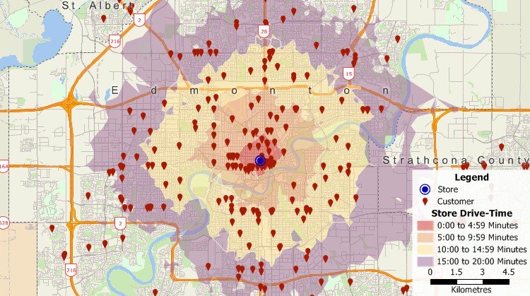
Build custom territories based on areas, proximity, or drive time

Identify weighted concentrations of features and over- and under-served areas

Filter features based on location and geographic attributes as well as conditional data attributes

Determine trade areas and identify valuable sites

Customize feature styles, heat maps, charts, 3D maps, and more

Measure distances and find shortest and fastest routes
Once you understand the patterns hidden
in the numbers, share your maps to tell your stories. Copy them to reports
and slideshow presentations, save them to images for use on websites, or
print them out as handouts or wall-size posters.
Maptitude mapping software is only US$695 and includes a FREE country package ($595 value) that includes an up-to-date street layer with addresses for pin-mapping (geocoding) and travel time information for computing routes and drive-time rings. Also included are building footprints for many urban locations, railroads, and comprehensive named landmarks that range from public facilities to commercial buildings including shops, restaurants, and retail stores. Postal data and detailed demographics (where available) are shipped with the product. In addition, Maptitude has no subscription fees, and supports secure off-line data storage*.
|
Maptitude Reviews and Testimonials |
|
*
Maptitude Online is available for customers that require online
sharing or a Cloud application.
Maptitude subscriptions are available for customers that prefer
them to our one-time payment pricing.
 Check out our G2 Reviews
