

Winter 2018
Welcome!
Welcome to the Winter 2018 edition of Caliper’s transportation newsletter. In order to enhance communications with our ever-growing customer community, we are reinstituting our newsletter for TransCAD and TransModeler users, our consulting clients, and other interested transportation professionals. This is an auspicious moment as we are on the cusp of the release of major new versions of each product. Both should be available shortly in advance of TRB. Also, we have ramped up our consulting and research activities in order to bring cutting-edge solutions to market more quickly than would otherwise occur.
TransCAD 8.0 Release
In its eighth major version, our market-leading TransCAD software continues the tradition of augmenting the existing functionality and improving computational performance for travel demand modeling and GIS applications. Some highlights are noted below.
General Transit Feed Specification (GTFS) Editing –
One of the notable enhancements requested by users is the handling
of GTFS files and making them readily usable for transit
accessibility calculations and travel demand model applications.
TransCAD 8.0 can import GTFS files and automatically place the
routes on an accurate street layer such as a HERE database. Once
imported into TransCAD, public transport routes can be edited,
future routes can be added, and the routes can be exported to a new
GTFS file that can be read by FTA’s STOPS program.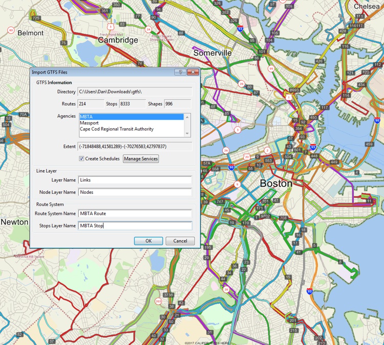
New Discrete Choice and ABM Modules – While all major ABM variants run with TransCAD, we are providing native discrete choice and ABM modules to provide friendlier and higher-performance computations in future new models. Added to the set of provided models are easy-to-apply nested logit models for destination choice with optional shadow pricing to enforce destination trip total constraints. TransCAD will also support application of the Multiple Discrete Continuous Extreme Value (MDCEV) and hazard duration models.
New Graphics and Reporting Engine – We have replaced all of the charts and reports with a much more powerful and elegant set of capabilities. There are many more chart types and reports, and all are enhanced for greater readability and enhanced presentations.
Flowchart Interface Enhancements – The flowchart interface is now the preferred way to run models. TransCAD provides a flowchart-based model manager that is a graphical environment to let developers easily assemble models and specify inputs, outputs, and model parameters. For model users, the flowchart interface helps modelers understand the structure of demand models, set up parallel processing, and launch scenario runs.
Scenarios are maintained in an efficient hierarchy. The model manager includes a data manager that keeps track of all model and scenario runs, results, and scenario inputs and outputs. A user can choose a scenario, and the data manager can show the date and time of the run, can show all logging and reporting, and can display and open all input and output files from that run.
Vehicle Routing Solutions – TransCAD has been enhanced to
work well with data from HERE, and Caliper can supply routable
national street datasets for many countries. In conjunction with
facilitating the use of HERE data for routing in TransCAD, we have
added a new vehicle routing toolbox and enhanced vehicle routing
solutions.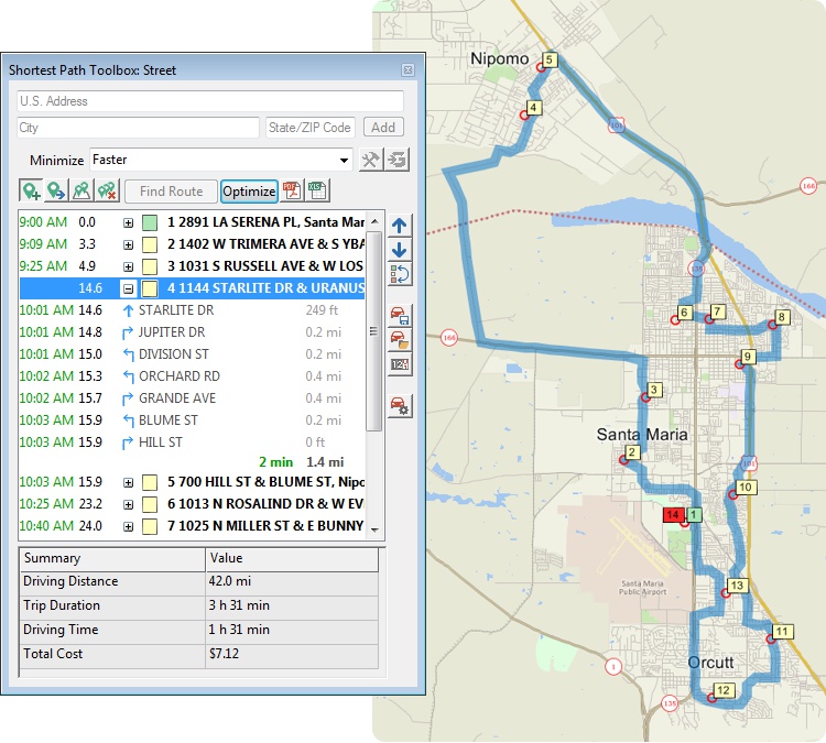
Checking Networks and Best Routes with Google – Ever wonder if your own road networks give routes that are reasonable and are the same as or similar to those from Google? A new tool in TransCAD will automatically query Google and let you compare shortest paths from place to place. You can also generate travel time and distance matrices.
Say Goodbye to Dongles – We have switched to a software key for new versions. For many of you, getting a new TransCAD will entail simply getting a download.
TransModeler 5.0 Release
TransModeler 5.0 has been dramatically enhanced in both its core features and performance as well as in heightened ease of use. Users will notice that their models will run faster in both microscopic and mesoscopic simulations, especially on computers with many CPU cores.
Simplified but Enhanced Geographic Editing – Based on feedback from users, we have further refined and simplified the geographic editing tools in TransModeler. There is now a more user-friendly road editing experience with visual and text cues for multi-click edit actions. Tools for automatic roundabout creation with splitter island geometry are also significantly enhanced.
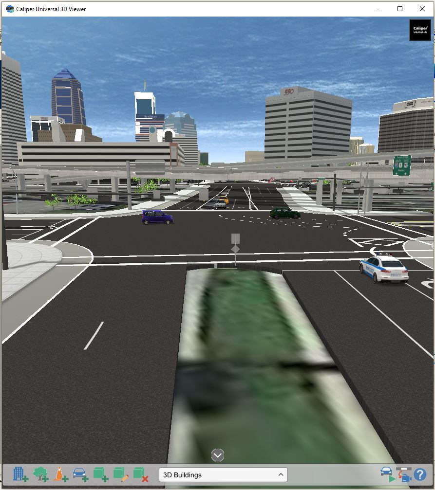
A Completely New 3-D Solution – There has been a vast improvement in realistic depiction of traffic in 3D landscapes and cityscapes achieved through integration with the powerful Unity gaming engine.
More Faithful Traffic Signals and Control – To the already deep traffic signal controller emulation capability, support has been added for:
- Time-of-day Signal plan transition
- Pedestrian interruption and correction in coordinated systems
- Rail fixed-block signaling systems
- At-grade rail crossing signal control
Automated Vehicles and Cooperative Adaptive Cruise Control – TransModeler simulates connected and automated vehicles in the traffic stream, adhering to SAE International’s six levels of vehicle automation.
Improved Roundabout Modeling – Whether it is road editing, turning volume data entry, or simulation of gap acceptance and right-of-way driving behaviors, nearly every aspect of roundabout modeling has been updated in 5.0 to enhance ease of use and enable more accurate simulation of capacity and level of service out of the box.
Activity Based Model Integration – If you have an ABM or are thinking about developing one, TransModeler 5.0 offers a more easily integrable dynamic traffic assignment (DTA) solution that is capable of directly and explicitly simulating trip lists and linked trips as part of tours. TransModeler simulates individual trips and route choices and can feed individual trip travel times and/or dynamic skim matrices back to the ABM.
No More Dongles – As with TransCAD 8.0, we have switched to a software key for new versions!
Some Recent Caliper Projects of Note
Exploring the Effects of Connected and Automated Vehicles
No topic has generated more interest in recent years than the expected impacts of connected and automated vehicles. Yet most analyses of impacts have been highly speculative and often made heroic assumptions about benefits.
In an FHWA-funded study, Caliper is working with RSG to explore possible impacts using a unique test bed for Jacksonville, Florida. Using the North Florida TPO DAYSIM activity-based model and a calibrated TransModeler microsimulation based dynamic traffic assignment (DTA) model, the project team is systematically examining how changes in travel behavior and travel supply associated with connected and automated vehicles could interact to change the transportation landscape in the future. The emphasis is on exploratory modeling rather than on prediction, and this is facilitated by modeling various combinations of travel behavior changes, penetration of CAV technologies, and specific CAV scenarios. For more information, contact Dan Morgan (daniel@caliper.com) or Howard Slavin (howard@caliper.com).

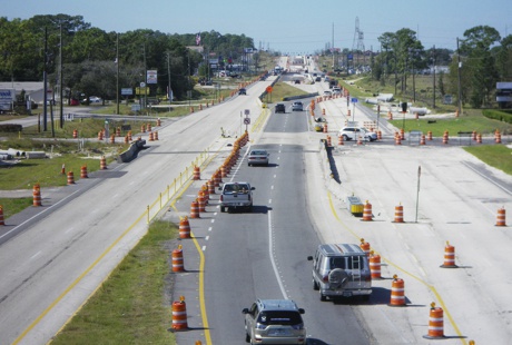
Work Zone Delay Estimation and Construction Scheduling
How much delay is caused by work zones, and can it be reduced by clever scheduling and sequencing of construction projects? With funding from the SHRP2 program and in collaboration with Metroplan Orlando, the University of Central Florida, and the Association of Monterey Bay Area Governments (AMBAG), Caliper has been re-implementing the Work Zone Impacts and Strategies Estimator (WISE) software for work zone construction scheduling and adapting it to take advantage of existing travel demand models and emerging DTA solutions. WISE has been re-formulated as a TransCAD application to take advantage of the TransCAD traffic assignment tools and database environment.
Two pilot projects are being performed to test the new software and analytical approach. In both Orlando and Monterey, future projects have been analyzed in terms of the traveler delay associated with alternative construction schedules. In each case, schedules that minimize a weighted combination of construction cost and traveler delay have been identified. For more information, contact Jim Lam (jimlam@caliper.com).
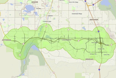
Managed Lane Revenue Forecasting with TransModeler and DTA
Managed lanes pose special challenges for analysis due to the complications posed by dynamic varying tolls, time-varying traffic flows, and the need to maintain a minimum speed in the tolled lanes. Traditionally, the analysis of proposed toll projects has been done using planning models with static traffic assignments loosely coupled with a microsimulation model of only the corridor, if at all. However, this methodology, lacking consistent representation of the operational capacities of access and egress areas as well as the effects of queuing and spillback, can lead to biased results.
For the Colorado Department of Transportation (CDOT), Caliper has been providing traffic simulation and dynamic traffic assignment (DTA) services in support of traffic and revenue (T&R) estimation for proposed managed lanes on C-470 in Denver, CO. The project is a Level 3 traffic and revenue analysis and explores various tolling policies and strategies as well as geometric configurations on the corridor. In the analysis, Caliper used the Denver Regional Council of Governments (DRCOG) activity model, FOCUS, to estimate trip patterns in conjunction with field observations of origin-destination patterns to calibrate and validate the model. Simulation-based DTA and dynamic origin-destination matrix estimation (ODME) tools were employed to develop the calibrated model.
The technical approach to the T&R analysis centered on microsimulation-based DTA as a tool for computing drivers’ route choices in the presence of various tolling schedules and policies. The approach harnessed the operational sensitivity of traffic microsimulation – incorporating an incredible amount of detail in terms of road geometry, traffic signalization, and ramp metering operations – together with the powerful dynamic equilibration of DTA to provide accurate predictions of revenues, managed lane capture, and a variety of performance measures. For more information, contact Dan Morgan (daniel@caliper.com) or Janet Choi (janet@caliper.com).
Traffic Assignment and Feedback Research to Support Improved Travel Forecasting
Completed nearly two years ago, this landmark study for U.S. DOT is having a continuing, positive impact on modeling practice in the United States and elsewhere. The study reviewed MPO modeling practices including all aspects of traffic assignment model formulation, application, and validation. The study found many shortcomings in existing practices and identified numerous straightforward improvements that can be implemented with existing tools.
The research illustrated that with careful formulation and a high degree of convergence, traffic assignment models appear to give plausible estimates of project impacts. Unfortunately, the required convergence levels are much higher than previously thought. At levels previously used, there were significant errors in projections including counterintuitive results in which road capacity improvements could easily result in longer travel times and increased congestion. The study final report can be downloaded here.
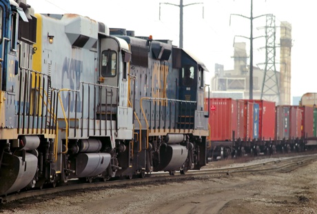
Federal Rail Administration Dynamic Waybill Traffic Assignment Model
For FRA, Caliper has developed and maintained RailFlow, a dynamic model of rail shipments throughout the United States. RailFlow is a custom application of TransCAD that uses an accurate and up-to-date rail network that Caliper developed for the project. The connected network includes ownership, trackage rights and haulage rights, along with speed estimates for different types of trains. Flows are assigned from origin stations to destination stations using geocoded FSACs. The network also includes links used by Amtrak and commuter railroads along with their routes and schedules. A powerful query tool makes it simple to obtain flows by railroad, railroad subdivision, commodity, origin, destination, junction, passenger route, or departure date. Outputs include flow maps and tables, tabulations and cross-tabulations of waybills, and origin-destination matrices by station or geographic area. For more information, contact Robert Freimer (robert@caliper.com) or Howard Slavin, (howard@caliper.com).
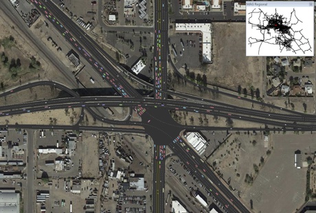
Phoenix Regionwide DTA Model Development
In 2017, Caliper completed a project to expand an already very large microsimulation model of Central Phoenix to the entire service area of the Maricopa Association of Governments (MAG) covering Maricopa and Pinal Counties. The model incorporates signal timing and ramp metering data from over 30 government agencies; simulates auto, bus, and light rail traffic; and was calibrated to 15-minute counts and validated to 15-minute speeds from the National Performance Management Research Data Set (NPMRDS). Advanced dynamic traffic assignment and dynamic origin-destination matrix estimation techniques were used to calibrate and validate the model, which simulates almost 3,700 signalized intersections and over 3.8 million trips in the 5-hour PM peak period. The model is a significant step for MAG toward better operations analysis in the planning for and evaluation of major projects. For Caliper, the project represents a substantial achievement in the pursuit of scalable microsimulation and DTA for entire metropolitan regions. For more information, contact Dan Morgan (daniel@caliper.com).
Multi-Resolution Traffic Modeling for Las Vegas
Caliper was recently awarded a contract by the Southern Nevada Regional Transportation Commission (RTC) to develop a multi-resolution dynamic traffic assignment model for the Las Vegas region. A multi-resolution model incorporates the travel demand model, a regionwide dynamic traffic assignment model, and a fine-grained microsimulation of one or more subareas or corridors. For more information, contact Howard Slavin (howard@caliper.com) or Dan Morgan (daniel@caliper.com) or stay tuned for future developments.
Utah DOT Long Range Plan
Caliper is partnering with ICF and Fehr & Peers to develop the Utah DOT 2019-2050 Statewide Long Range transportation Plan (LRP). The effort has two phases:
- Strategic Phase (Phase 1) - Develop a strategic framework and implementation plan, using FHWA’s PlanWorks tool, for the updated LRP
- Tactical Phase (Phase 2) – Create and publish the LRP
In the Strategic Phase, the team is performing an assessment and improvement of the long-range planning process using PlanWorks, prior to initiation of the actual plan development. The objective of this review is to ensure that the Plan serves as a stronger and more integrated first step in an improved project development process that delivers a more effective program of projects and services to UDOT customers.
Caliper will be leading the Tactical Phase, providing national statewide planning expertise in both the Strategic and Tactical phases and supporting database applications and travel modeling efforts throughout. For more information, contact Paul Hershkowitz (ph@caliper.com).

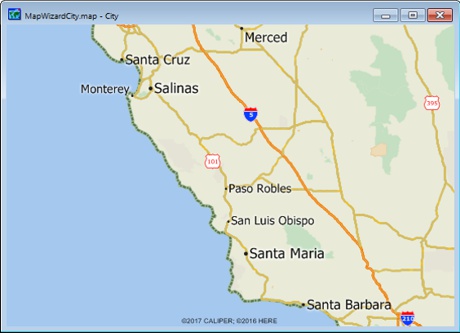
An Activity-Based Model (ABM) for Three Central Coast California MPOs
With funding from Caltrans, Caliper is currently developing a state-of-the-practice ABM for the Central Coast California MPOs of Santa Barbara (SBCAG), San Luis Obispo (SLOCOG), and Monterey Bay (AMBAG). For this project, Caliper is developing a common activity-based modeling framework for each MPO and will implement improved, calibrated, and validated models for each MPO region. The objective is to estimate practical ABMs that will calibrate and validate better than current trip-based models.
The ABM modeling platform will be based on the TransCAD flowchart GUI and disaggregate logit modeling engine. It will have a desktop orientation and an effective user interface. All models will be readily accessible through the GUI, and all coding will be accessible as GISDK open source code.
Freight Data Assessment for the I-95 Coalition
Caliper is working with the I-95 Corridor Coalition staff to develop an approach for enhancing the Coalition staff’s internal understanding of the current state of the practice of freight data. We are also assisting in outlining what initial steps need to be taken for expanding access to, and usability of, freight data. The study is comprised of three tasks, which are: (1) assisting the Coalition staff in developing a list of questions about freight data for Coalition members; (2) creating a matrix that outlines the sources of selected freight data with various criteria, and; (3) crafting recommendations for specific steps that the Coalition staff can take to assist their members in obtaining and using freight data. For more information, contact Paul Hershkowitz (ph@caliper.com).
The HEPGIS Web Application
FHWA’s HEPGIS is a web-based interactive geographic map server application developed by Caliper that allows users to navigate and view geo-spatial data, print maps, and obtain data on specific features using only a web browser. It includes geo-spatial data used for transportation planning. HEPGIS is being used to demonstrate emerging trends to address MPO and statewide planning regulations/requirements, enhanced National Highway System, Primary Freight Networks, commodity flows and safety data. HEPGIS has been used to help implement MAP-21 regulations and will help implement the Grow America Act, particularly related to Ladder of Opportunities and MPO reforms.

From the Archives: Farecards in New York City

A little more than 20 years ago, Caliper performed a fare policy study for New York MTA in advance of the introduction of farecards. The study, which included extensive market research with travelers, estimated the ridership and revenue impacts of a variety of farecard types, including options with an unlimited number of rides per month.
A decade ago, Caliper created software to process the farecard transaction data to estimate the origins and destinations of transit trips within New York City. This was particularly challenging because farecards are only swiped upon entering the subway or boarding a bus and there is no record of the destination of any of the trips. Also, the initial system only recorded boardings in six-minute intervals making the location of bus boardings subject to considerable error. Nevertheless, the Caliper software used a variety of methods to estimate each trip’s destination and intermediate transfers resulting in a very detailed portrait of ridership by location and time of day. For more information, you can consult https://www.caliper.com/pdfs/caliper-entry-only-fare-collection-data-to-estimate-linked-transit-trips.pdf or https://www.caliper.com/pdfs/caliper-mta-farecard-final-report.pdf.
Recently, New York MTA announced that they will be instituting a new and greatly enhanced farecard system. This new system will provide comprehensive data on origin-destination patterns and time of day of travel enabling transit planners to provide even better service and build better forecasting models.
See You at TRB!
Once again Caliper will have a booth (#501) in the Exhibit Hall at TRB and a hospitality suite (2-046) in the Marriott Marquis in the evenings. Visit our suite to discuss how we can help you with your travel forecasting and traffic simulation needs on Monday, Tuesday, or Wednesday from 5:30-8:00 PM or by appointment. Stay tuned for further details.
HAPPY HOLIDAYS TO ONE AND ALL!
©2018 Caliper Corporation. All Rights Reserved. TransCAD and TransModeler are registered trademarks of Caliper Corporation.