Maptitude Help / Surface Analysis Tools / Finding a Shortest Path Over Terrain
Finding the Shortest Path over Terrain from a Grid Layer
You can use Maptitude to find shortest paths over terrain from a grid layer. To find a shortest path over terrain, you use the Terrain Shortest Path toolbar to define an origin and destination and to choose how accurately to compute the shortest path and how much to penalize changes in elevation.
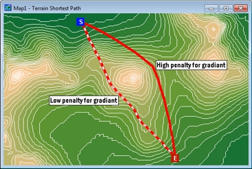
The map below shows two different paths between a pair of points. The dashed route has a low penalty for gradient and is steeper and straighter than the solid route which has a high penalty for gradient.
 To Find a Shortest Path over Terrain from a Grid Layer
- Open a grid geographic file, or choose a grid layer in the current map.
- Choose Tools>3D>Terrain Shortest Path to open the Terrain Shortest Path toolbar.
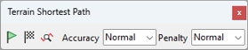
- Click
 to activate the Define Origin Point tool.
 - Click on the map where the path should start. Maptitude places a marker where you clicked.
- Click
 to activate the Define Destination Point tool.
 - Click on the map where the path should end. Maptitude places a marker where you clicked.
- Choose a level of accuracy:
| Option | What it does |
|---|---|
| Low | Maptitude uses less processing time and the route is less detailed |
| Normal | Maptitude balances the processing time and the detail of the route |
| High | Maptitude uses more processing time and the route is more detailed |
- Choose the penalty to apply to gradient:
| Option | What it does |
|---|---|
| Low | Maptitude weighs distance more than changes in elevation when finding the shortest path. Paths will be shorter and hillier. |
| Normal | Maptitude weighs distance and changes in elevation equally when finding the shortest path. |
| High | Maptitude weighs changes in elevation more than distance when finding the shortest path. Paths will be longer and flatter. |
- Click
 .
.
Maptitude calculates the shortest path over the terrain and displays the path on the map as a freehand line. You can return to step 3 to change the settings and calculate another shortest path.
©2026 Caliper Corporation