Maptitude Help / Sharing Your Maps / Linking Documents, Files, & Web Sites to Map Features
Linking Documents, Files, & Web Sites to Map Features
In addition to sharing your maps with other applications as discussed earlier in this chapter, you can also link all types of information to features on a map. By placing the correct information in a field in a table associated with a geographic file, you can link map features to documents, programs, or websites. There can be any number of these link fields.
The link field must have a name that includes the word “File” (for example, Photo File, Web Site File, Data File, etc.). You can rename a field in a dataview using the Dataview>Fields>Properties command, or in the table itself, using the Dataview>Table>Modify command. If your layer does not have a field in which to store the document or program file name, use the Dataview>Table>Modify command to add a new character field. Note that the field must be wide enough to hold the full path and file name. For more information see Working with Tables, Databases, & Charts.
When you access a link to another Windows application file, Maptitude launches the appropriate program which opens the document or website. When you access a link to another Maptitude file (map, dataview, figure, or layout), Maptitude opens the file and displays it in another window. When you link to Word or Excel documents, you can link to a specific position in a file by adding a vertical bar and the name of a bookmark, cell, or range. For example:
| To link to... | Enter this in the link field | Example |
|---|---|---|
| A website | The URL | https://www.caliper.com |
| A picture | The full path and file name | C:\Users\Me\Pictures\image.jpg |
| A Word file | The full path and file name, and optionally a bookmark | C:\Users\Me\Documents\My Report.docx|Appendix A |
| An Excel file | The full path and file name, and optionally a cell or range | C:\Users\Me\Documents\My Data.xlsx|database |
Maptitude lets you launch any Windows application, with optional arguments to be passed to the application. For example, you could run an application that polls a traffic control for its status and displays the data in a message. Put the full path and file name in the field, including the extension, such as .exe. If you are passing arguments, put them after a vertical bar. For example, “c:\program files\myprogs\poll.exe|-i643” might run the Poll application and pass the identifier 643 as an argument.
Once you create a link, you can access it in two ways:
- By clicking on the feature with the Info Link
 tool
tool - By clicking on the feature with the Info
 tool and then clicking the
  symbol in the Info window.
 To Link a Document, Program, or Web Site to a Map Feature
- If necessary, use the Dataview>Table>Modify command to create a new field that includes the word “File.” Make sure that the field is wide enough to hold the full path and file name.
- Find the feature that you want to link, either by scrolling through a dataview, using the Edit>Find command, or by using the Info tool.
- Type the link information in the link field as outlined below:
| To do this... | Do this... |
|---|---|
| Link a picture, sound, or video file to the feature | Type the path and file name of the picture, sound, or video file. |
| Link an application document to the feature | Type the path and file name of the document (and any Word bookmark or Excel cell or range after a vertical bar). |
| Link an application to a feature | Type the path and file name of the application, and any arguments after a vertical bar. |
| Link a URL to the feature | Type the web page URL. |
Maptitude stores the link.
To Access Links with the Info Link Tool
- Click to activate the Info Link tool.
- Click on a map feature. If the feature has more than one link field, Maptitude displays a toolbar that lists all of the links. Click on a link.
Maptitude determines the type of link, and either launches the appropriate application (if it is not already running) and displays the document or web page, or runs the specified application (with any optional arguments).
You can continue to use the Info Link tool to display links for any number of map features.
To Access Links with the Info Tool
- Click to activate the Info tool.
- Click on a map feature. Maptitude displays data for the feature in the Info window.
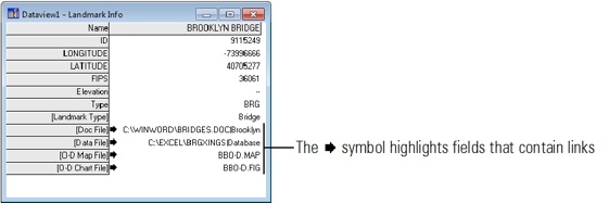
- Use the scroll bars to locate the link fields.
- Click on a
 symbol next to a link field.
Maptitude determines the type of link, and either launches the appropriate application (if it is not already running) and displays the document or web page, or runs the specified application (with any optional arguments).
You can continue to use the Info tool to display links for any number of map features.
©2026 Caliper Corporation