Maptitude Help / Geographic Analysis Tools / Facility Location
Solving a Facility Location Problem
Facility Location Models are used to identify good locations for warehouses, hospitals, retail stores, manufacturing facilities, and other types of facilities. In general, the goal in locating such facilities is either to provide a high level of service or to minimize operating costs.
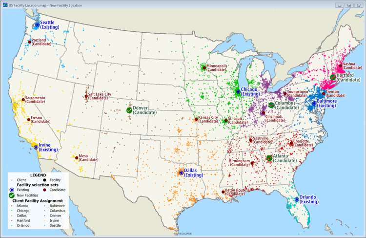
Facility location problems involve choosing the best location for one or more facilities from a set of possible locations. Here are two examples:
- You need to determine the best location for a new branch of a public library. Your goal is to provide the best overall level of access to city residents.
- You need to determine the best location for a new police station. Your goal is to reduce the maximum distance a patrol car needs to travel from the station to a resident’s home.
The goal of a facility location problem may be to determine the number of facilities that are required to guarantee a prescribed level of service. For example:
- You want to locate fire stations so that every building in a city is within five minutes of a station
- You need to locate voting stations so that the average resident is less than two miles away from the nearest one
There are also facility location problems where the goal is to maximize the distance between facilities and the population they serve. Landfills and power plants, for example, are often located relatively far from major population centers.
A final complication in facility location problems involves the presence of existing facilities. The locations of these facilities obviously affect the choice of locations for new facilities. In addition, a common situation involves both adding new facilities and closing one or more existing facilities.
Issues in Facility Location
In a facility location problem, the goal is to locate one or more facilities. The locations for these facilities are chosen from a set of candidate locations. In a regional warehouse location problem, for example, you may have identified half a dozen parcels that you can acquire for a new facility; in a nationwide location problem you may have chosen 25 metropolitan areas as possible facility sites. Typically, there is also a set of existing facilities to be considered in evaluating new locations.
Each facility serves a number of clients. In some cases (e.g. library or polling place) the clients are individuals or households, while in other cases (e.g. warehouse) the clients are stores or manufacturing facilities that are served by the facility. In some cases a client may require more deliveries than another client located the same distance away. In this situation, you can apply a weight to apply more importance to the clients who require more deliveries.
Sometimes you may want to consider closing existing facilities as part of a facility location problem. In this case, you treat the facilities that might be closed as candidate facilities rather than as existing facilities. The procedure then determines whether these facilities should be closed or kept in operation.
Solving the Facility Location Problem
Facility Location Inputs
The data for a facility location problem consist of:
- A point or area layer of client locations. The client layer can contain an optional weighting field.
- A point or area layer containing the candidate facility locations. If there are existing facilities to be considered, you must make separate selection sets of the candidate and existing facilities. The same features cannot appear in both of these selection sets. Existing locations that you are considering closing should be in the candidate set.
Facility Location Optimization Options
To solve a facility location problem, you must choose your objective. In general, the goal of a facility location problem is one of the following:
- Provide the best overall level of service to clients, without worrying about whether service to any particular client is much worse than average
- Provide the best possible service to the client who is farthest away from the set of facilities; often used for emergency services
- Keep facilities away from clients by placing the facilities as far as possible from the nearest client; often used for facilities that are considered to be undesirable, such as landfills or incinerators
You can either indicate the number of facilities you want to locate or allow Maptitude to determine the number that is required to meet a specific objective. When you have Maptitude determine the number of facilities, you choose whether to base the limit on an average time or distance to maintain for the serviced clients or on a maximum acceptable time or distance to service a client. Maptitude will find the smallest number of facilities to open to satisfy the criteria that you chose.
Facility Location Results
There are two primary outputs from the facility location procedure:
- A selection set of the locations of the new facilities. This selection set is always a subset of the features that were included in the candidate location set, and is automatically displayed on the map.
- A table that contains one record for each client that indicates the facility to which each one is assigned and the time/distance from that client to its assigned facility. If a weighting field was applied to the client set, the client assignment table will contain a weighted time/distance equal to the time/distance multiplied by the value in the weighting field. This table is automatically joined to the client layer and displayed in a dataview. It can be used to create thematic maps illustrating the assignment of clients to facilities.
 |
For a video tutorial see: (Internet connection required) |
 To Solve the Facility Location Problem
- Open a map that contains a point or area layer of clients and a point or area layer of candidate facility locations. If the facility layer contains any existing sites, create selections separate selections sets of the existing and candidate facilities.
- Choose Tools>Analysis>Facility Location or click
 Facility Location in the analysis tools drop-down on the Standard toolbar to open the Facility Location wizard and make choices as follows:
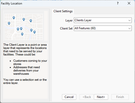
- Choose the layer that contains the clients from the Layer drop-down list
- Choose whether to use all features or a selection set from the Client Set drop-down list
- Click Next and make facility choices as follows:
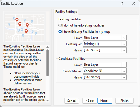
- In the Existing Facilities frame, choose whether or not you have existing facilities from the radio list. If you do have existing facilities, choose the layer that contains the existing facilities, the selection set that contains the existing facilities, and a field in that layer that contains the site name or other identifier.
- In the Candidate Facilities frame, choose the layer contains the candidate facilities, whether to use all features or a selection set, and a field that contains the site name or other identifier
- Click Next and make choices as follows:
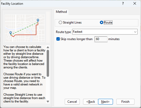
- Choose whether to base the facility location on straight-line distance or driving routes from the radio list
- If you chose the Route method, choose whether to balance the facility locations by drive-time (fastest) or by distance (shortest) from the Route type drop-down list.
- If you chose the Route method, choose whether to skip routes that exceed a threshold distance or time from the facility location calculation. Check Skip routes longer than and enter a maximum value in the edit box. Clients that exceed the distance will not be factored into the facility location problem and will not be assigned to a facility in the facility assignment table.
- Click Next and choose the number of new facilities as follows:
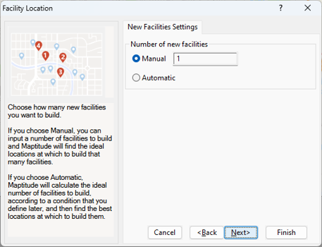
- Choose Manual from the radio list to specify the number of facilities and enter a number in the box
- Choose Automatic from the radio list to have Maptitude determine the number of facilities according to conditions that you will specify in the next step.
- Click Next and choose how you want to optimize the new facilities.
If you chose the Manual option in the previous step, make choices as follows:
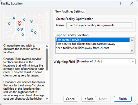
- Choose whether to place the facilities to provide the best overall service, to provide the best service to far-away clients, or to favor far-away facilities.
- Choose a field from the Weighting Field drop-down list to weight the values or choose Not Weighted to treat all clients equally.
If you chose the Automatic option in the previous step, make choices as follows:
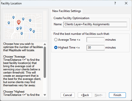
- To find the best facility location(s) that bring the average cost of servicing your clients below a certain threshold, choose Average Time/Distance <= from the radio list and enter a value in the box. This will create an assignment that is the best for the average client, but some clients may find themselves very far away.
- To find the best facility location(s) that bring the cost of service for every individual client below a the threshold, choose Highest Time/Distance <= from the radio list and enter a value in the box.
- Click Finish.
Maptitude determines the best facility location(s) from the candidates, creates a selection set of those locations, and highlights them on the map. Maptitude also opens a dataview of the facility assignment table joined to the client layer.
Try It Yourself: Solving a Facility Location Problem
1. Choose File>New Workspace, choose New map of my data/table/spreadsheet from the first scroll list, and click OK.
2. In the Tutorial folder, open the Excel spreadsheet with logistics data for your country (e.g., Logistics Australia.xlsx, Logistics United States.xlsx, etc.).
3. Choose the Sites sheet and click OK. Maptitude displays Create-a-Map Wizard.
4. Click Next>, choose the first "Locate" option in the scroll list, and click Next>. Then click Next> again to import the data.
5. Check the Display Labels box, verify that the Site Name field in the spreadsheet is chosen in the drop-down list, and click Finish. Maptitude locates five candidate sites and displays the Results dialog box.
6. Click OK to display a map of the sites.
7. Click the style sample next to Sites Layer in the Display Manager and change the size to 14, change the symbol to a square, and click OK.
8. Now that the candidate facilities are on the map, you need to add the clients. Choose Map>Add Table/Spreadsheet to a Map, choose the same logistics spreadsheet, and click Open.
9. Choose the Clients sheet and click OK.
10. Click Next>, make sure that the Add your data to existing map box is checked, choose the first "Locate" option in the scroll list, and click Next>. Then click Next> again to import the data.
11. Remove the check from the Display Labels box and click Finish. Click OK to see the 60 clients on the map. Now that the clients are also on the map, you are ready to run the Facility Location procedure.
12. Choose Tools>Analysis>Facility Location or click Facility Location in the analysis tools drop-down on the Standard toolbar to display the Facility Location wizard.
13. Verify that Clients Layer is chosen in the Layer drop-down list and All Features is chosen in the Client Set drop-down list, and click Next>.
14. Choose I do not have existing facilities from the radio list and verify that Sites Layer is chosen in the Layer drop-down list, All Features is chosen in the Candidate Set drop-down list, and Site Name is chosen in the Name drop-down list, and click Next>.
15. Choose Route from the radio list, verify that Fastest is chosen in the Route Type drop-down list, and click Next>.
16. Choose Manual from the radio list, enter 2 in the edit box to identify the two best facilities from the candidate sites, and click Next>.
17. Choose Best overall service from the scroll list, choose [Number of Units] from the Weighting Field drop-down list, and click Finish. Maptitude determines the facilities to open and highlights them on the map in a new selection set called "New Facilities."
18. Verify that Clients Layer is the working layer and click  Color Theme in the thematic mapping drop-down on the Standard toolbar.
19. Choose [Facility Name] from the Field drop-down list and click OK. Maptitude adds a color theme to the customers indicating which facility serves them.
20. Choose File>Close Workspace and click Don't Save to close the workspace without saving any changes
©2026 Caliper Corporation