

Winter 2021-2022
Welcome!
Welcome to our Winter 2021-2022 newsletter and a Happy New Year to you and yours. We are doing our best to progress our products and projects while continuing to hope for a return to normalcy at some point in the future.
COVID has brought changes for all of us. Notable changes at Caliper have been our adaptation to remote working and gradual evolution into a more geographically distributed workforce. In addition to our Massachusetts headquarters, Caliper now has transportation staff in the following locations:
|
|
|
For those of you residing in our new locations, we hope that our greater proximity will bring us more frequent interactions and bring you even better service.
After nearly two years of virtual presentations at virtual conferences, we have been looking forward to more in-person meetings. However, out of an abundance of caution, most Caliper staff did not attend TRB in January, nor did we exhibit there. In lieu of our traditional activities there, we will be arranging webinars that will be scheduled after TRB.
In this newsletter, we would like to update you on our activities in the past year:
- TransModeler 6.1 Release
- TransCAD 10 Preview
- Strategic Transportation Model Version 1.0 for Lima Peru
- Recent and ongoing projects
- New data useful for modeling
TransModeler 6.1 Release
TransModeler 6.1 is now available! TransModeler is the world’s most modern and effective traffic simulator blending greater realism in driver and vehicle behavior with unparalleled support for modern and future traffic management strategies, all while achieving unprecedented levels of computational performance. Here are some highlights:
CAV Modeling
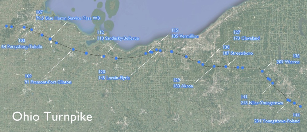
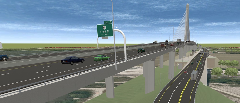
With Version 6.1, there are major upgrades in the modeling of vehicle platooning and other aspects of connected and autonomous vehicles (CAV). In addition, there is support for new advanced transportation management strategies (ATMS), including speed harmonization and new ramp metering control algorithms. These capabilities were brought to fruition to support a project for Ohio DOT exploring the impacts of connected and autonomous vehicles on the Brent Spence Bridge in Cincinnati and on 200 miles of the Ohio Turnpike.
Enhanced Driver Behavior Models
There are also advances in driver behavior models. Notably, there is a newly developed model of two-stage gap acceptance at two-way stop-controlled intersections.
This adds to the list of important road and traffic features, such as two-way left turn lanes (TWLTL), on-street parking, peak period shoulder running, and reversible lanes, that are supported without the need for significant customization, duplication of model networks, or modeling approximations.
Adaptive Ramp Metering
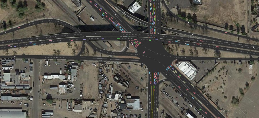
TransModeler 6.1 was used to simulate the Arizona Department of Transportation’s adaptive ramp metering algorithm MaxFlow for the Maricopa Association of Governments. To support this effort, the application programming interface (API) in TransModeler 6.1 was enhanced to make it simpler and more cost-effective to implement and test custom ramp metering strategies in addition to the several that can be simulated in TransModeler out of the box without any programming at all.
Improved Automation, 3D Animation, and Output Visualization
TransModeler 6.1 also incorporates new simulation run automation tools for more efficient alternatives analysis, sensitivity testing, scenario planning, and exploratory modeling and analysis. There are also substantial upgrades to 3D animation and simulation output visualization that elevate communication of project benefits.
Highway Safety Manual Calculations
TransModeler 6.1 integrates the Highway Safety Manual (HSM) Part C predictive methods for freeways, ramps, and ramp terminal intersections. Many of the geometric data that are routine inputs for microsimulation in TransModeler are also drivers of safety performance. Further, the extensible GIS architecture of TransModeler, which makes it ideal for warehousing traffic data such as AADT that also feed safety analyses, makes TransModeler a natural platform for storage and management of safety data and metrics. Now, simulation models created for operational analyses are a quick and cost-effective starting point for your safety analysis, and vice versa.
Improvements for DTA and DTA Integration with Travel Demand Models
To support the use and integration of traffic simulation and simulation-based dynamic traffic assignment (DTA) with travel demand models, TransModeler now provides deployment-ready integrations with ActivitySim, DaySim, and CT-RAMP for metropolitan areas around the country. As a result of these efforts, we have further refined the underlying software architecture, achieving faster running times and expanding support to more varied tour and trip list formats.
To increase the utility of mesoscopic simulation and mesoscopic-based DTA models, we have improved the operational fidelity and running times of the mesoscopic model in TransModeler. Mesoscopic models that have results that more closely approach those from microsimulation are an important advance and greatly enhance the validity of hybrid meso-micro traffic models and DTA models.
Expansion of Lane-level GIS Mapping
With TransModeler, we continue to pioneer and demonstrate the value of lane-level GIS. Our lane-level mapping of the U.S. road system continues to expand and provide TransModeler users with free data to jumpstart their simulation and traffic impact projects. Lane-level road maps capture the geometric details not only for improved simulation models but also provide critical inputs for safety analysis using HSM and highway inventory reporting.
Visit https://www.caliper.com/transmodeler/ or email us at TransModeler@caliper.com to learn more about TransModeler 6.1 and the groundbreaking work we are doing.
TransCAD 10 Preview
Work on TransCAD 10 is well underway with a projected release in mid-2022. TransCAD 10 will have many new and enhanced features. These improvements include considerable new functionality and even greater computational performance.
Importantly for our thousands of international users, TransCAD 10 has full support for Unicode and will handle data field names and labels properly in your native language.
Improved Flowchart Interfaces for Model Users and Model Developers
One area of improvement is in the evolution of the flowchart interface to make it even easier for model developers and model users to control model execution, monitoring, and output visualization. This user interface makes it easier to control parallel execution of computing tasks, to access model inputs and outputs, and to produce informative maps and graphics.
Activity-based Model Support
Given the increasing numbers of activity-based models, we have developed and are evolving unique support for them, including ActivitySim. Our flowchart interface implementation for it provides control over numerous model components and subcomponents as well as an easy means of editing model parameters.
Predicted individual and household tours and can be visualized to help understand model behavior and results.
Distributed Processing
With TransCAD 10, Caliper will be introducing a completely new set of tools for platform support of distributed processing across multiple computers. This is a particularly efficient means of speeding up computations for very large models. Importantly, the new implementation makes it easy to setup the distributed computations and transfer the necessary input and output files.
New and Improved Traffic Assignment Tools
Continuing our tradition of providing the broadest array of traffic assignment tools for modelers, we have been refurbishing and enhancing a broad array of static and dynamic traffic assignment models in TransCAD. There will also be improved dual bandwidth themes for mapping assignment outputs.
More Convenient Licensing
TransCAD 10 will also feature a new, more flexible and more convenient copy protection scheme. This will make it easier to make use of network licenses.
A special welcome to our new users
TransCAD Transportation Planning Software’s market share continues to increase in both the U.S. and elsewhere. Lima, Peru is the latest world city to switch to TransCAD for travel demand modeling.
The Authority for the Metropolitan Area of Lima (PERU), through an administrative act, officially adopted the "Strategic Transportation Model Version 1.0" developed in the TransCAD platform (version 9.0). TransCAD has also been adopted as the software for mobility planning and public transportation. The Authority has purchased 30 licenses for the product that will be distributed among the different agencies of the province that consists of 50 districts of Lima and El Callao and has about 11 million inhabitants.
Una bienvenida especial a nuestros nuevos usuarios
Las autoridades del Área Metropolitana de Lima, capital del Perú, mediante acto administrativo, adopto oficialmente, el “Modelo Estratégico de Transporte Versión 1.0” desarrollado en el entorno de la plataforma TransCAD (versión 9.0) y a este como software para planificación de la movilidad y el transporte público, adquiriendo para tal fin 30 licencias del producto que serán distribuidas entre las diferentes agencias de la provincia que agrupa 50 distritos de Lima y El Callao y cuenta con cerca de 11 millones de habitantes.
Highlights of Some Recent and Ongoing Project Work
In our project work, as in our product development, we seek to improve and refine the methods that are available for transportation analysis. Below we describe some recent project work that may be of interest.
FAF 5 Freight Flow Disaggregation and Network Assignment Model and Data Release
Caliper is completing work for Federal Highway Administration (FHWA) Office of Freight Operations to develop methods and software to assign truck trips from the Freight Analysis Framework (FAF) 5 to a national road network. The software first disaggregates the FAF5 commodity flows and allocates them among approximately 3,500 county-to-county and port origins and destinations before converting commodity flows to truck trips and assigning them. A new national road network was developed and used for this purpose. The resultant flow data for the base year of 2017 will be released by FHWA by early 2022 and will be followed by forecasts based on estimates of future commodity flows.
For this project, Caliper created new methods and software to model truck flows on a national network. The FAF5 origin-destination flows are preserved at the FAF-to-FAF zone level but are disaggregated to the more detailed zoning system based upon production and attraction relationships by commodity. Commodity flows by truck for each commodity are then converted to estimated truck trips using load factors for different types of trucks.
Since intercity truck movements do not follow equilibrium assignment rules, a path-based route choice model was implemented. For each origin-destination pair, attractive routes are identified and then flows are assigned based on estimated congested travel times and tolls using a logit choice model with a correction for overlapping paths. Checks against truck routes derived from GPS traces from the American Transportation Research Institute (ATRI) indicated that the path enumeration and flow allocation methods are quite realistic. We believe that this methodology can be used to greatly enhance statewide and regional freight models.
Application software for FAF5 disaggregation and network assignment was built as a custom TransCAD 9 add-in. The software, which can be used to assess the effects of network closures on truck traffic, has a very capable query engine. The query engine supports analysis of flows by commodity group, origin or destination county, FAF zone, or state, and by select link groups.
The new modeling methodology and query tools will be available in the form of an add-in to TransCAD 9 with additional and more generalized functionality coming in TransCAD 10.
Next Generation Triangle Regional Model
Caliper has developed an entirely new, advanced trip-based model for the North Carolina Research Triangle region covering the Raleigh, Durham, Chapel Hill metropolitan area. The model was developed for, and is maintained by, the Institute of Transportation Research and Education (ITRE) at North Carolina State University on behalf of the two local MPOs, the local transit agency, and NCDOT. The new model incorporates novel machine learning methods for trip generation and new hierarchical destination choice models as well as numerous best practices such as population synthesis, linkage of home-based and non-home-based trips, parking models, an all-streets network, flow chart interface, and network management tools.
The new model replaces the original model for the Triangle region that had been incrementally updated and refreshed over the past two decades. Over this extended period of time and multiple updates, the model scripts and network had become cluttered and difficult to work with, so the partner agencies decided that the time had come to rebuild the model from the ground up. Although development of an activity-based model was considered, the partner agencies elected to develop a new, advanced trip-based model for a number of reasons including development cost, model runtime, and existing skills and knowledge base of the agency staff and consultants who would be using the model.
GitHub for GISDK Script and Input Management and Online Documentation
GitHub was used for coordination and management of the model development effort and will be used by ITRE and the partner agencies going forward for ongoing maintenance and development of the model. The use of GitHub makes it easy to identify the official model of record and share it among the partner agencies and with consultants for project work. It also allows the model documentation to be hosted online, together with the model, in an editable, wiki format, that can be updated and kept current with the model into the future.
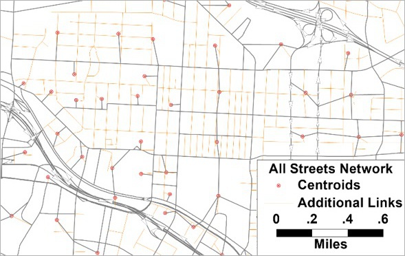
All-Streets Network for Walk, Bike, and Walk Access to Transit
A new network was developed for the model including all local streets. While the model’s traffic assignment still uses centroid connectors and ignores local streets and roads, the inclusion of these minor streets was instrumental for both the non-motorized and transit components of the model. The non-motorized models are sensitive to the density and connectivity of local streets with increased walking and biking with more dense and connected networks. The transit network uses the local streets as an elegant access and egress alternative to a multitude of centroid connectors, and the inclusion of the local streets also eliminates the common problem that occurs when transit routes travel over roads not included in the traffic assignment network.
Fast Population Synthesis
The demand models begin with the TransCAD population synthesis procedure. Caliper Corporation’s own iterative proportional updating (IPU) algorithm is much faster than other alternatives and generates a synthetic population of over 1.8 million people in just over two minutes. The use of synthetic populations in trip-based models is an increasingly common best practice that reduces aggregation bias and allows trip generation and other front-end demand models to make use of richer demographic information with more variables than the limited two or three used in a cross-classification approach.
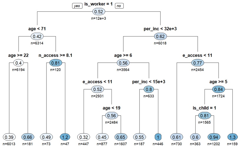
Explainable Artificial Intelligence for Trip Generation
The home-based trip generation models are person-level models, applied to individual people in the synthetic population. These models can still make use of household characteristics but can also use person characteristics such as age as explanatory variables. As part of the model development, Caliper tested all of the traditional trip generation model forms – cross-classified trip rates, generalized linear regression models, and logit models – as well as newer machine learning methods. In every case, the machine learning (ML) methods offered improved goodness-of-fit over traditional models. However, the initial ML models were not easy to understand or explain and susceptible to over-fitting. Therefore, a second batch of ML models in the form of rationalized decision trees were developed embracing the principle of Explainable Artificial Intelligence or "XAI" which has been advanced by federal defense research. These models use Analysis of Variance (ANOVA) to produce decision trees that are readily understandable, incorporating multiple demographic and neighborhood characteristics in ways that make intuitive sense. The resulting rationalized decision trees still significantly out-perform traditional models while also being transparent and behaviorally defensible and are implemented entirely in the TransCAD GISDK script.
Hierarchical Destination Choice Models
New hierarchical destination choice models were developed in which travelers first choose the general area or district for their destination and then choose the precise zone. This hierarchical approach helps overcome the loss of spatial information such as adjacency in treating destination choice as a discrete choice among competing alternatives. The use of a higher-level, district geography helps capture shared characteristics of zones within a community and the biases of members of one community towards or against others. In a highly multinucleated region such as the Triangle region, with many distinct communities such as Raleigh, Cary, Durham, and Chapel Hill, this approach was particularly advantageous in reflecting the actual patterns of destination choice observed in the household survey.
Transportation Network Companies (TNCs) and New Modes
The mode-choice models included a new nest for non-household autos which have traditionally been ignored. The nest includes two new modes. One is an "Auto Pay" mode which combines taxi, rental cars, and TNCs like Uber and Lyft, which many people recognize are of growing importance. The other is perhaps less visible but represents cars borrowed from neighbors and friends which, as evidenced by survey data, is an important mode for households that lack autos of their own.
Parking Models
Parking is limited and priced in the downtown and campus areas of the Triangle region, and some of these areas have free shuttles between them and remote parking. Therefore, the new model incorporates parking choice models. These models, based on the 2016 parking survey, predict the zone where the driver will park and whether they will walk or ride a free shuttle based on their destination and the number and price of parking spaces in the zones. By including the logsum of these choice models in the utility of the auto modes, travelers’ mode and destination choices are also made sensitive to parking considerations.
Linkage of Non-Home-Based Trips
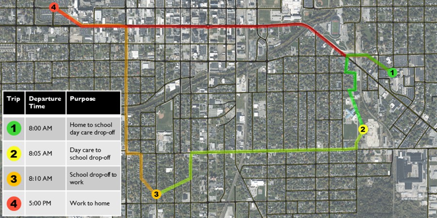
Non-home-based trips are generated separately for each mode based on home-based trip destinations and modes as well as on mode-specific accessibility to other nearby attractions. This approach, another increasingly common best practice, ensures the spatial and modal consistency of non-home-based trips with home-based trips. For example, if a scenario results in more home-based trips to downtown Raleigh, the scenario will also produce more non-home-based trips in and around downtown Raleigh. Also, to the extent that these new home-based trips are auto trips, more of the non-home-based trips will be as well; whereas, to the extent that the new home-based trips are by transit, more of the non-home-based trips will be by walking and a perhaps a few by transit.
While much attention is given to activity-based models, the new Triangle Regional Model showcases best practice in advanced trip-based modeling which offer many of the same benefits of activity-based models. The model is sensitive to neighborhood characteristics like walkability, parking costs and availability, as well as a rich set of demographic variables, and the model ensures the consistency of modes and locations on trips within the same tour. The model provides the Triangle region’s partner agencies a powerful, but understandable and easy-to-use tool to support their planning analysis needs.
Exploratory Modeling Analysis Tool (EMAT) with TransCAD and TransModeler in Las Vegas
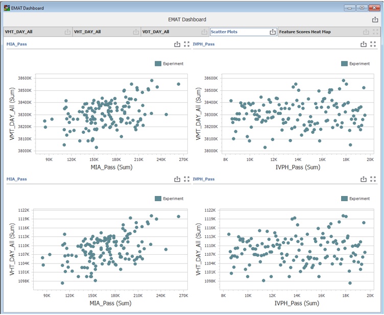
As part of a project sponsored by FHWA’s Travel Model Improvement Program (TMIP), Caliper is working with the Regional Transportation Commission of Southern Nevada (RTCSNV) to demonstrate the use of TMIP’s Exploratory Modeling Analysis Tool (EMAT) tool with both TransCAD and TransModeler. TMIP’s EMAT is an open-source Python program to support analysis under uncertainty. The project is the first application of the tool with a dynamic traffic assignment (DTA) model, and as part of the project Caliper has developed an API that allows the user to call EMAT functions from GISDK and facilitates running large numbers of model experiments in TransCAD and TransModeler.
The project builds on Caliper Corporation’s prior experience using exploratory modeling analysis (EMA) with DTA. In 2018, as part of another FHWA TMIP funded project, Caliper used EMA to study the effects of connected/autonomous vehicles (CAVs) and ridesharing using an integrated ABM-DTA model of the Jacksonville, Florida, region. The project also leverages the TransModeler DTA model of the Las Vegas region previously developed by Caliper for RTCSNV.
The new API allows TransCAD and TransModeler users to access EMAT functions from GISDK so that separate Python scripting is not required. The new functionality is being used with RTCSNV’s TransCAD model to explore issues including uncertainty in visitor levels and e-commerce following COVID. In TransModeler it is being used to explore varying levels of demand for sports events as well as certain aspects of traffic flow. The API also facilitates easy creation of TransCAD dashboards for visualizing EMAT results such scatter plots of model experiments and feature scores.
A Wide Area DTA for the Michigan DOT for the Detroit Region
For the Michigan DOT, Caliper completed and delivered a regional mesoscopic dynamic traffic assignment model of the Detroit region in 2020. The model is compatible with the Southeast Michigan Council of Governments’ (SEMCOG) regional travel demand model, allowing the travel model to quickly produce demand estimates for analyses requiring operational sensitivity. The DTA model is designed to support multi-resolution modeling, giving MDOT and SEMCOG a tool from which microsimulation models for major projects can be efficiently produced. In 2021, Caliper continued its work for MDOT, developing a tool for streamlining comparison of alternatives and scenarios and performing convergence analysis that will help MDOT perform DTA effectively in future projects.
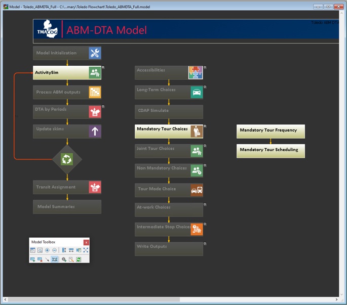
Toledo ActivitySim-TransModeler Integrated ABM-DTA Model System
In partnership with the Toledo Metropolitan Area Council of Governments and the Ohio Department of Transportation (ODOT), Caliper is developing an integrated activity-based model (ABM) and dynamic traffic assignment (DTA) for Toledo, Ohio, using ActivitySim and TransModeler. The project builds on Caliper Corporation’s previous experience with ABM-DTA integration and leverages the ability to assign trip lists from activity-based models in TransModeler. As part of the project Caliper has developed a user-friendly flowchart interface for ActivitySim in TransCAD that allows users to leverage the open-source ActivitySim software without the need for Python programming. Caliper also enhanced the core ActivitySim code to accept dynamic skims from DTA. The new model illustrates how an open-source package like ActivitySim can be successfully integrated with Caliper Corporation’s proprietary software and how TransCAD and TransModeler can improve the usability and usefulness of ActivitySim.
The integrated model system makes use of rich data resources including Ohio’s statewide household travel survey, ODOT’s big data resources, and extensive count coverage, as well as leveraging the existing regional model’s auxiliary demand components.
The ActivitySim model was initially based on the SEMCOG’s implementation for the neighboring Detroit metropolitan region. ActivitySim first had to be modified to represent the more limited set of transit alternatives available in the Toledo area, a process that required both Python programming and the modification of multiple configuration files. The core ActivitySim code was also modified to accept dynamic skims from TransModeler rather than broad multi-hour period skims from a traditional, static assignment model. The model parameters are now being calibrated to the local household travel survey data.
A key benefit of the integration of ActivitySim with TransCAD and TransModeler is the ability to make use of the TransCAD flowchart interface which helps the user set up and run the model, and to view and change model inputs, outputs, and parameters. The flowchart approach employs boxes connected in a logical sequence that mirrors the planning model process flow. Users can clearly visualize ActivitySim’s component steps and interact with the same to view, modify, and edit its constituent inputs and parameters. The integration of ActivitySim with TransCAD also provides the benefits of the TransCAD built-in database engine for efficiently managing the heavy intermediate outputs generated, the TransCAD GIS for quickly and efficiently visualizing, analyzing, and editing model inputs and outputs, and the TransCAD dashboards for visualizing the rich model outputs provided by activity-based models like ActivitySim.
The TransModeler DTA covers the whole region and represents the Toledo roadway network in great detail. The DTA makes use of the TransModeler mesoscopic simulation capabilities for network loading, but can easily support multi-resolution modeling with microsimulation of subareas for project studies. TransModeler offers several benefits for integration with activity-based models. TransModeler can load trip lists from activity-based models ensuring that travelers cannot depart for a new trip until their prior trip and activity are complete. Furthermore, TransModeler can also visualize the sequence of trips and activities that comprise a tour. TransModeler provides detailed dynamic skims back to ActivitySim reflecting traffic conditions throughout the day and also offers the ability to visualize the region‘s traffic and future traffic solutions in stunning 3D imagery, leveraging satellite photography and building models together with the detailed representation of the roadway infrastructure and users that TransModeler provides.
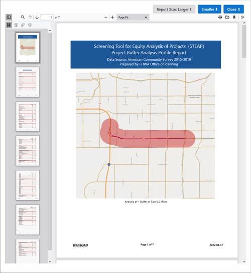
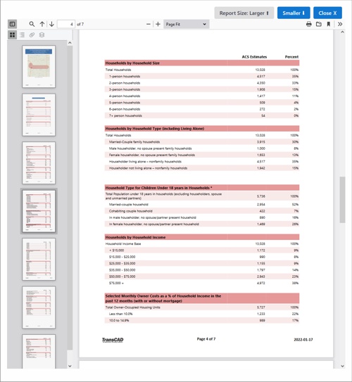
Equity Screening Tool for FHWA’s Office of Planning
For FHWA's Office of Planning Caliper has developed a new Screening Tool for Equity Analysis of Projects (STEAP) enabling FHWA, State DOTs, MPOs, and other practitioners to generate equity analysis project profile reports without the need for GIS specialists to perform the work.
STEAP is an extension of HEPGIS website that provides preliminary screening of potential project locations anywhere in the United States to support Title VI, environment justice (EJ) & other socioeconomic data analyses. STEAP features a simple user interface that permits planners to compute buffers around potential road projects and report relevant demographics. According to FHWA, STEAP has gained popularity among FHWA HQ and Division Offices, state DOTs and MPOs and it is expected that a new and expanded version of the tool will be produced in the future.
Some New Data Available
U.S. Census Data
Continuing a legacy of more than three decades, we are now providing the latest U.S. Census data to our users. Some of these data are delayed from the Census Bureau and will be provided when they become available.
Latest HERE Routable Roads and Streets
For 2022, we have current, comprehensive HERE road data for the U.S. and many other countries available for license. Typically, the vintage of these data will be 4th quarter 2021.
New U.S. Major Roads Network
Caliper has developed a geospatial database of major roads in the United States that will be available free of charge to licensed TransCAD and TransModeler users. The Caliper National Road Network (CNRN) includes all Interstate Highways and U.S. public roads functionally classified as Principal Arterials or higher, as well as other roads that serve as connectors to major airports, water ports, intermodal freight and passenger terminals, key defense installations, and U.S. border crossings with Canada and Mexico. Selected major roads in Canada are also included to provide alternative road connections between U.S. cities and Alaska. All road features in the database are topologically connected to enable network pathfinding and traffic assignments. The CNRN can be used “as is” for regional and national level highway analyses or can serve as a starting point for creating more detailed metropolitan or statewide highway networks.
Key features of the CNRN include:
- Dual centerline representations for all controlled access divided highways, such as Interstates and other non-Interstate expressways.
- Inclusion of all interchange ramps connecting road features represented in the CNRN.
- Indicators of allowed traffic flow direction for all one-way road segments, including dual centerline travel ways and interchange ramps on divided highways.
- Positional accuracy of most road alignments consistent with 1:5000 scale digital imagery (i.e., ± 10 meters or better).
- Centroid connectors to all U.S. counties, major cargo airports, major water ports, and U.S. border crossings with Canada and Mexico.
- Identification of all U.S. toll facilities, including toll roads, bridges, and vehicle ferries.
- Identification of roads and connecting interchange ramps that comprise the National Highway System, the Strategic Highway Network and the National Highway Freight Network.
Each road segment record contains up to 50 attribute fields including local road names, numbered sign route and concurrent routes, locational proxies (state, county, urbanized area), road type, functional classification, number of lanes, posted speed, identification of major bridges, tunnels, and toll facilities, and highway interchange numbers. The CNRN will be maintained and updated at least annually, with additional road segments and attributes added as they become available.
New hardware and its implications for model performance
We are currently testing the latest computers from Intel and AMD to assess their performance for TransCAD and TransModeler models. As has been our custom, we maintain a technical memorandum that provides recommendations for new hardware setups, and we will be updating it shortly when we conclude the latest round of testing.
Please feel free to contact us for further information about our products, services, and project work.
©2022 Caliper Corporation. All Rights Reserved. Caliper, TransCAD, and TransModeler are registered trademarks of Caliper Corporation.