Maptitude Help / Projections and Coordinate Systems / About Coordinate Systems
About Coordinate Systems
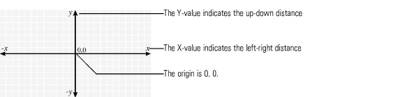
A coordinate system is a method for identifying the location of a point on the earth. Most coordinate systems use two numbers, a coordinate, to identify the location of a point. Each of these numbers indicates the distance between the point and some fixed reference point, called the origin. The first number, known as the X value, indicates how far left or right the point is from the origin. The second number, known as the Y value, indicates how far above or below the point is from the origin. The origin has a coordinate of 0, 0.
Longitude and latitude are a special kind of coordinate system, called a spherical coordinate system, since they identify points on a sphere or globe. However, there are hundreds of other coordinate systems used in different places around the world to identify locations on the earth. All of these coordinate systems place a grid of vertical and horizontal lines over a flat map of a portion of the earth, like this:
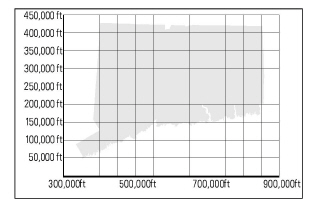
A complete definition of a coordinate system requires the following:
- The projection that is used to draw the earth on a flat map
- The location of the origin
- The units that are used to measure the distance from the origin
Maptitude organizes coordinate systems into the following groups:
- State Plane and other 1927 North American Datum coordinate systems: a series of over 170 coordinate systems, or Zones, used for maps of various regions in the United States and Canada.
- State Plane and other 1983 North American Datum coordinate systems: a series of over 140 coordinate systems, or Zones, used for maps of various regions in the United States and Canada
- Universal Transverse Mercator (UTM): a series of 60 coordinate systems that use the Transverse Mercator projection. The coordinate systems are intended for small regions worldwide.
- Gauss-Krüger: a series of 60 coordinate systems that use the Transverse Mercator projection. The coordinate systems are intended for small regions worldwide.
- Africa: a series of over 60 coordinate systems.
- Asia: a series of over 45 coordinate systems.
- Australia and New Zealand: a series of over 80 coordinate systems.
- Central and South America: a series of over 70 coordinate systems.
- Europe: a series of over 60 coordinate systems.
- World: Lon/Lat and Web Mercator coordinate systems
All of these coordinate systems measure distances in meters, except for a few Indian subcontinent coordinate systems, and the 1927 State Plane Coordinates, which measure distances in feet. For a complete list of coordinate systems, see Supported Projections and Coordinate Systems in the Maptitude Help.
You can display Maptitude geographic files using any one of these coordinate systems. When you do so, you can also choose to see the position of the cursor in the status bar either in the selected coordinate system or in degrees of longitude and latitude.

- Right-click on the map window and choose Properties, to display the Map Properties dialog box.
- Make sure that the Auto Projections box is not checked.
- Click Change Projection to display the Projection and Coordinate System dialog box.
- Click the Coordinate System tab.
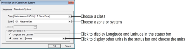
- Choose a class from the Class drop-down list.
If you have chosen UTM and the coordinates have a False Northing, check Adjust for Southern Hemisphere. You can also choose a different ellipsoid from the Ellipsoid drop-down list.
If you have chosen Gauss-Krüger and the coordinates have a False Easting, check Zone Factor Adjustment. You can also choose a different ellipsoid from the Ellipsoid drop-down list. - Choose a zone or system from the Zone drop-down list.
- Choose whether to display the coordinates in Longitude and Latitude in the status bar or to display other units in the status bar from the Show Coordinates in radio list.
- Click OK to return to the Map Properties dialog box.
- Click OK.
Maptitude draws the map using the chosen coordinate system and the appropriate map projection.
If you choose a coordinate system that is inappropriate for the scale and center of your map, Maptitude displays a message that the coordinate system cannot be used at the current scale and center. If you are looking at a map using a certain coordinate system and you change the map scale or center by a large amount, Maptitude may determine that the one you chose can no longer be used. When this happens, Maptitude chooses the best projection for the area displayed.
Several geographic files are provided to help you determine the correct zone: ccspcs27.cdf for the 1927 State Plane Coordinate system, ccspcs83.cdf for the 1983 State Plane Coordinate system, and ccutm.cdf for the UTM zones.
 |
TIP: You can also get to the Map Properties dialog box by clicking |
 on the Standard toolbar and then clicking
  in the Properties column of the map you want to modify.
©2026 Caliper Corporation