Maptitude Help / Projections and Coordinate Systems / About Ellipsoids
About Ellipsoids
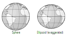 Ever since it was discovered that the Earth was round, spherical globes have been used to represent the Earth. Unfortunately, the Earth is not really a perfect sphere; it bulges out around the equator and its poles are slightly flattened. A more accurate, but still imperfect, representation of the Earth’s shape is an ellipsoid, which is an ellipse rotated around its shorter axis.
Different reference ellipsoids have been used for surveying various regions of the world, such as the Clarke 1866 ellipsoid for North America and the Airy ellipsoid for Great Britain. Until recently, the ellipsoids were often chosen to give a “best fit” for a particular region, with little concern for how well they represented the remainder of the Earth. This minimized the local positional errors but led to the creation of incompatible maps that are difficult to stitch together into a worldwide geographical dataset.
In the later part of the twentieth century, new geocentric ellipsoids (e.g. GRS80, WGS72, and WGS84) were defined to make worldwide mapping feasible. The new ellipsoids are centered at the Earth’s center and attempt to minimize the overall distortion for the entire planet. The resulting model is suitable for worldwide mapping, but creates slight positional errors in certain regions.
Many of the coordinate systems supported by Maptitude specify a particular ellipsoid in their definition. For example, the NAD27 State Planes use the Clarke 1866 ellipsoid and the NAD83 State Planes use the GRS80 ellipsoid. General worldwide coordinate systems such as Universal Transverse Mercator (UTM) and Gauss-Krüger are defined independent of the ellipsoid. For these coordinate systems, Maptitude lets you choose the proper ellipsoid.

- Right-click on the map window and choose Properties, to display the Map Properties dialog box.
- Make sure that the Auto Projections box is not checked.
- Click Change Projection to display the Projection and Coordinate System dialog box.
- Click the Coordinate System tab.
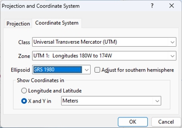
- Choose the Universal Transverse Mercator (UTM) or Gauss-Krüger class from the Class drop-down list and choose a zone from the Zone drop-down list.
- Choose the desired ellipsoid from the Ellipsoid drop-down list.
- Click OK to return to the Map Properties dialog box.
- Click OK.
Maptitude draws the map using the chosen coordinate system and ellipsoid.
 |
TIP: You can also get to the Map Properties dialog box by clicking |
 on the Standard toolbar and then clicking
  in the Properties column of the map you want to modify.
Datum and Coordinate System Conversions
Maptitude always stores geographic data using longitude and latitude coordinates, even if you choose to display other coordinates in the status bar.
You can easily import data created in another coordinate system into Maptitude, or export geographic data from Maptitude to files that use other coordinate systems. For more information, see Using Data in Other Coordinate Systems. Maptitude also lets you perform conversions between the various datums that are used to define longitude and latitude. For more information, see Advanced Coordinate Conversion.
©2026 Caliper Corporation