Maptitude Help / Managing Geographic Files / Using Data in Other Coordinate Systems
Using Data in Other Coordinate Systems
Maptitude stores the locations of map features in degrees of longitude and latitude. However, Maptitude can import and export the locations of map features in many other coordinate systems, including State Plane Coordinates, Universal Transverse Mercator (UTM), Australian Map Grid, and others.
To import or export data in a different coordinate system, you use the Coordinate System dialog box to indicate the coordinate system you want to use and the units in which the data are stored.
UTM coordinates for the Southern Hemisphere often have a False Northing of 10,000,000 meters added to them. You can indicate that these coordinates should be imported or exported with a False Northing. Gauss-Krüger coordinates may have a False Easting equal to the zone number times 1,000,000 meters. You can indicate that these coordinates should be imported or exported with a False Easting.
The default ellipsoid for UTM coordinates is the GRS 1980 ellipsoid, and the default ellipsoid for Gauss-Krüger coordinates is the Krassovsky 1940 ellipsoid, but you can choose another ellipsoid. See About Ellipsoids for more information. If you need to change the datum or use a linear transformation to import or export data, see Advanced Coordinate Conversion.
To avoid problems with lines or areas crossing the 180/-180 degree meridian, you can split them at that longitude.
To learn more about coordinate systems and map projections, see Projections and Coordinate Systems.
 To Import Data from a Different Coordinate System
- Begin the import procedure for the particular file type you are importing. Specific import procedures for each file type are presented in Importing Geographic Files.
- When Maptitude displays the Import dialog box for the file type you have chosen, click Coordinates. Maptitude displays the Import Coordinates dialog box.
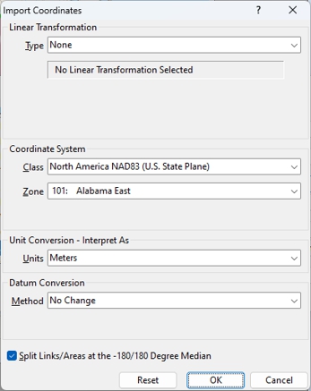
- Choose the class of coordinate system from the Class drop-down list and the zone of the coordinate system from the Zone drop-down list.
If you have chosen UTM and the coordinates have a False Northing, check Adjust for Southern Hemisphere. You can also choose a different ellipsoid from the Ellipsoid drop-down list.
If you have chosen Gauss-Krüger and the coordinates have a False Easting, check Zone Factor Adjustment. You can also choose a different ellipsoid from the Ellipsoid drop-down list. - If necessary, choose units for the conversion from the Units drop-down list and choose a datum conversion from the Method drop-down list.
- Check the Split Links/Areas at the -180/180 Degree Meridian box to split lines and areas.
- Click OK to return to the Import Geography dialog box.
- Return to and complete the import procedure for the particular file type you are importing.
To Export Data to a Different Coordinate System
- Begin the export procedure as described on here.
- When Maptitude displays the Export Geography dialog box, click Coordinates. Maptitude displays the Export Coordinates dialog box.
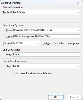
- Choose the class of coordinate system from the Class drop-down list.
- Choose the zone of the coordinate system from the Zone drop-down list.
- If you have chosen UTM and you want to add a False Northing to the coordinates, check Adjust for Southern Hemisphere. You can also choose a different ellipsoid from the Ellipsoid drop-down list.
If you have chosen Gauss-Krüger and you want to add a False Easting to the coordinates, check Zone Factor Adjustment. You can also choose a different ellipsoid from the Ellipsoid drop-down list.
- Click OK to return to the Export Geography dialog box.
- Return to and complete the export procedure.
©2026 Caliper Corporation