Maptitude Help / Projections and Coordinate Systems / About Map Projections
About Map Projections
A map projection is a method for taking the curved surface of the earth and displaying it on something flat, like a computer screen or a piece of paper. There are many different ways of doing this. In the first figure below, the earth is sliced into strips and the strips are laid out flat next to each other. As you can see, the spaces between the strips make it difficult to read.
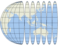
If we stretch the edges of each of the strips until they meet, we get a map that looks like this:
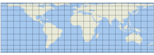
To make this continuous, flat map of the earth, we stretched, or distorted, certain parts of the map. All flat maps of the earth cause some kind of distortion. The amount and type of distortion depends on the projection that is used.
Automatic Projections
When you use Maptitude, you don’t really need to know anything about map projections. Maptitude can choose a projection for each map automatically, and change projections as needed when you change the map scale or center.
Maptitude Auto Projection helps every map start with a sensible, analysis-ready view of the world. Map projections are one of the most technical parts of GIS because every flat map distorts the earth in some way. Maptitude reduces that burden by automatically choosing an appropriate projection for each map and updating the projection when the map scale or center changes.
This means users do not have to become projection experts before they can make reliable maps. Maptitude automatically chooses a projection, helping preserve the relative size of areas on maps. That makes it especially useful for business, demographic, sales territory, market analysis, and planning maps where comparing areas fairly is more important than manually selecting a coordinate system.
Choosing a Projection Yourself
While Auto Projection helps everyday users with their map making, Maptitude keeps the preserves the ability to choose from a broad projection and coordinate system library when a specialized cartographic or analytical requirement calls for it.
When you turn off Auto Projections, you have many choices to make and many different projections from which to choose. When a professional map maker thinks about what projection to use for a particular map, the decision is a complicated one that depends largely on two factors:
- The location and size of the area that is shown — Is the map large scale or small scale? Is the area shown on the map near one of the poles, near the equator, or somewhere in between? Is the region covered by the map taller than it is wide, or vice versa?
- The purpose of the map — What is the map intended to show? How will it be used?
There are many factors that a map maker might consider when choosing a projection and coordinate system. The following table describes three important characteristics that apply to some map projections. Note that there is no map projection with all three of these characteristics.
| Projection property | What it means | When to use it |
|---|---|---|
| Equal area | Regions that are the same size on the earth are the same size on the map | When showing color, pattern, and dot-density themes |
| Conformal | The general shape and orientation of areas are maintained | When it is important for regions on the map to have the correct shape |
| Equidistant | The distance between the center point of the map and any other point is correct | When you want to measure distances from the center of the map |
When you use automatic projections, Maptitude always selects an equal area projection. This guarantees that you can use color, pattern, and dot-density themes with no distortion of the size of areas on the map.
Examples of Different Projections
Here are two examples of maps that show North America. The map on the left uses an equal area projection, and correctly shows the relative size of regions on the map. Notice that the map correctly shows that Alaska is about twice the size of Texas. However, the shapes of areas on the map are distorted. Alaska is flattened and stretched so that it looks much shorter than it really is.
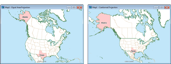
The map on the right uses a conformal projection, and correctly shows the shapes of areas such as Alaska and Texas. However, the sizes of areas on the map are distorted. Alaska now looks much larger than it really is.
Classes of Projections
Because there are so many different map projections, Maptitude organizes them into classes, where each class includes projections that are useful for maps of particular regions of the earth. This makes it easier for you to experiment with different map projections. The following table shows the classes of projections and the regions in which they should be used:
| Class... | Intended use... |
|---|---|
| U.S. and Canada | Maps that show all or parts of the United States and Canada |
| The World | Maps that show two or more of the continents, covering a large portion of the surface of the Earth |
| Equatorial Regions | Maps that show areas located at or near the Equator, usually between -23.5 degrees and +23.5 degrees of latitude (the Tropics of Capricorn and Cancer) |
| Polar Regions | Maps of areas located at or near the North Pole or the South Pole, below -66.5 degrees latitude or above +66.5 degrees latitude (the Antarctic and Arctic Circles) |
| Middle Latitudes | Maps of areas that are between the Poles and the Equator, between -66.5 and -23.5 degrees latitude, or between +23.5 and +66.5 degrees latitude |

- Right-click on the map window and choose Properties, to display the Map Properties dialog box. The map projection is shown in the Current box.
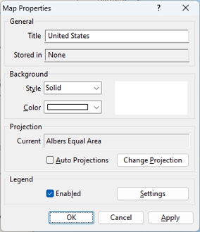
- Make choices as follows:
| To do this... | Do this... |
|---|---|
| Use automatic projections | Check the Auto Projections box. |
| Choose the projection | Remove the check from the Auto Projections box and click Change Projection to display the Projection and Coordinate System dialog box. Choose a class of projection from the Class drop-down list, a projection from the Projection drop-down list, and click OK to return to the Map Properties dialog box. |
- Click OK.
Maptitude draws the map using the chosen projection.
Some map projections cannot be used in certain regions of the world. For example, you can’t use the Albers Equal Area projection to show the entire world. If you choose a projection that isn’t appropriate for the area contained in your map, Maptitude will choose a different projection instead, just as though automatic projections were enabled.
 |
TIP: You can also get to the Map Properties dialog box by clicking |
 on the Standard toolbar and then clicking
  in the Properties column of the map you want to modify.
Using Projections with Image Layers
Whenever an image is used as a layer in a map, Maptitude locks the map projection to the projection for the image. Automatic and manual projections are disabled while the image layer is in the map. See Using Images as Map Layers, for more information.
©2026 Caliper Corporation