
NEWTON, MASSACHUSETTS - Caliper® Corporation is pleased to announce the release of an automated routing application. Designed primarily to support solid waste collection services, the application will generate efficient vehicle routes for solid waste collection over a street network, and can also be used for street cleaning, newspaper/postal delivery, and other applications that require an arc-routing solution with side constraints. Developed to run as an add-in to Caliper Corporation’s TransCAD transportation planning software, this program has been successfully implemented in cities around the world, and provides a user-friendly and cost-efficient solution for collection and delivery operations.
Sample
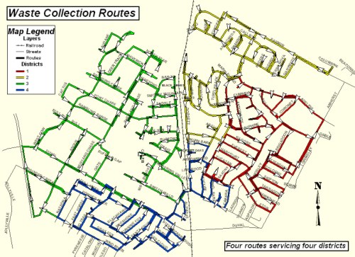
solid waste collection route map
 The application reduces operating costs by attempting
to create routes with minimal "deadheading." Deadheading is defined as the
time when the vehicle is moving but is not in service, e.g. back tracking
along a street that has already been serviced to get to another part of the
service network. The application also attempts to minimize undesirable or
unsafe vehicle movements, such as U-turns, and lets the user specify which
streets are to be serviced by a pass in each direction and which streets can
be serviced in a single pass (known as the meandering problem).
Furthermore, the program can also create shifts to meet driver work
requirements.
The application reduces operating costs by attempting
to create routes with minimal "deadheading." Deadheading is defined as the
time when the vehicle is moving but is not in service, e.g. back tracking
along a street that has already been serviced to get to another part of the
service network. The application also attempts to minimize undesirable or
unsafe vehicle movements, such as U-turns, and lets the user specify which
streets are to be serviced by a pass in each direction and which streets can
be serviced in a single pass (known as the meandering problem).
Furthermore, the program can also create shifts to meet driver work
requirements.
The
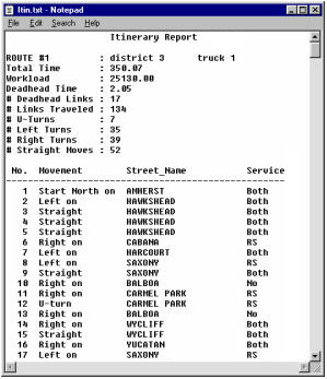
application creates a route map and a route itinerary report. Route maps
show the entire route system generated by the application with individual
vehicles routes displayed using different colors. Route maps can be
customized using the standard mapping functions provided with TransCAD. The
route itinerary lists the sequence and direction of road segments on each
route. The itinerary also includes the road name and the service mode
(deadhead, right service, or both curbs) for each segment, and provides
summary statistics for each route, including workload, total time, deadhead
time, and the number of turns by type.
Located in Newton, Massachusetts, Caliper Corporation
is a leading developer of geographic information system software (GIS) for
Windows. TransCAD Transportation GIS Software is the only commercially
available GIS that has been designed to support transportation applications.
TransCAD is currently used worldwide to support applications including
transportation planning, facilities management, and routing and logistics.
More information about Caliper GIS software, mapping software and
transportation planning software can be found
here.