|
|
 Maptitude
Spotlight: Maptitude
Spotlight:
Using
Outdated Data & Technology? Upgrade to
Maptitude 2013!
|
|
Users of Maptitude 2012 and Maptitude
6.0 can still get our US$395
reduced upgrade pricing. This
deal
saves you US$300! Upgrade now to avoid
being caught out by using last year's
features and data.
Also, each US order will include a free US
ZIP Code update: a US$250 value! The
combination of the offer and free data saves
you US$550!
Maptitude 2013 is a major new release.
Don't miss out on the most detailed
and accurate
data and demographics ever included.
For pricing and ordering information
please visit the
Mapping Software Store, e-mail
Maptitude Sales, or call U.S. Sales
at +1 617-527-4700.
Limited Offer: Valid for Maptitude 6.0
or later.
Restrictions Apply.
|
You need the newest maps, the latest demographics,
and the fastest, most
intuitive Maptitude!
  |
|
|
Maptitude Classroom Training:
Limited Availability!
Maptitude 2013 Training:
 Boston MA (May 6th-8th)
 |
|
 The
next scheduled instructor-led training courses
will be
May 6-8 in Newton, MA (USA).
Advance registration is required. The
next scheduled instructor-led training courses
will be
May 6-8 in Newton, MA (USA).
Advance registration is required.
The new and updated curriculum reflects
the features in Maptitude 2013.
Space is limited, so
register online as soon as possible.
If you have any questions, please call Maptitude
Training (USA) at +1 617-527-4700, or send
an e-mail to
sales@caliper.com.
|
|
|
|
Caliper also offers several training options:
•
Instructor-led classroom training
•
Private training
•
Web-based training
•
Free Learning Resources
•
Free Mapping Software Webinars
|
|
Free Mapping Resources: |
|
This month's free resource is the
release of a video detailing the
extensive capabilities of Maptitude 2013
for managing and creating territories.
The video has been updated to explain
how to create freehand/manual
territories:
•
Free Mapping Software Video
|
|
|
International News:
New Country Package: Germany |
|
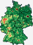 Caliper
is excited to announce a new
Country Package for Germany! The
product includes a wealth of data
and functionality unavailable in
any other software. Caliper
is excited to announce a new
Country Package for Germany! The
product includes a wealth of data
and functionality unavailable in
any other software.
Maptitude ships with one country
of your choice (see
complete list), and additional
Packages can be purchased separately
for US$595.
You can now seamlessly switch between
the countries you have purchased.
Doing so refreshes the Maptitude
interface with country-specific
tools such as those for finding,
pin mapping (geocoding), routing,
and using Create-a-Map Wizard.
If you have any questions, please
call Maptitude Sales (USA) at +1
617-527-4700, or send an e-mail
to
sales@caliper.com.
|
|
| |
Did You Know?
64-Bit
Maptitude |
|
 Maptitude
2013 runs as a 32-bit or 64-bit
application on 32-bit or 64-bit
Windows 8, 7, Vista or XP. Maptitude
2013 runs as a 32-bit or 64-bit
application on 32-bit or 64-bit
Windows 8, 7, Vista or XP.
The many advantages of a 64-bit
Maptitude include: the ability
to save to much higher
resolution images; the
capability to use more memory
than the previous 4GB 32-bit
limit; and being able to
open/import files via 64-bit
Microsoft Office (e.g. Excel and
Access).
|
|
| |
|
|
| |
|
|
Featured Data Product:
113th Congressional Districts
(USA)
NEW: Boundaries Reflect
Redistricting Changes; Now Includes 5-Digit ZIP
Code-to-District Lookup Table!! |
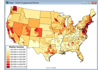
The 113th
Congressional Districts DVD is now available for
the entire USA. These are the most accurate boundaries
available, reflecting our expertise in the field as the
market leading
redistricting software package.
The Congressional Districts DVD is packed with essential
information for corporate legislative affairs
departments, lobbyists, political consultants, political
parties, and anyone else involved in political affairs.
You will be able to answer questions such as "In which
districts are my addresses located?" or "In which
districts should I expend the most effort?"
The 113th Congressional Districts Data contains a
nationwide area database with boundaries of the 113th
(2012-2014) Congressional Districts. It also includes
demographic data from the 2010 Census and from
the 2010 American Community Survey (ACS) 5-year
estimates.
A major new enhancement is the inclusion of the list of
congressional districts that intersect each 5-Digit ZIP Code.
Up to 4 Congressional districts are listed along with their
percentage overlap.
Price: US$495 for the entire USA.
Order online at the Caliper Store Now or call Maptitude
Sales (USA) at +1 617-527-4700.

|
Tech Tip:
Assigning
Postal/ZIP Codes to Stores & Sales Representatives |
|
Often there is a need to assign the areas that are
closest to a location. For example, you may have a list
of stores or employees and would like to see all the
postal areas color-coded based on which location they are
closest to.
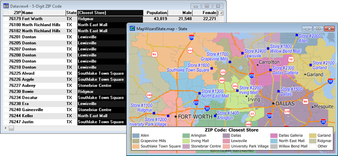
Maptitude lets you fill a field in a map layer table
with data from another layer by using the
Edit-Fill-Tag tool. You can, for example,
fill in a field with the name of the nearest feature in
another map layer or with the distance to the nearest
feature in another map layer. This is called tagging.
For example, suppose you are looking at a table of
customers. You could fill in one column in the table
with the distance to the nearest store and a second
column with the name of the nearest store (Maptitude
Video).
The
following steps illustrate how to tag areas using points by walking
you through using the tagging tool in Maptitude 2013:
-
Locate your point locations (e.g. addresses) on a
map as a new layer.
-
In the Display Manager (Map-Display Manager),
right-click on the area layer you want to tag. This is often a
postal layer such as "5-Digit ZIP Code" in the USA.
Choose New Dataview from
the menu.
-
Choose Dataview-Modify Table.
If the table is read only check your
Edit-Preferences-File Sharing settings
or contact
support@caliper.com.
-
Click Add Field in the Modify Table
window. Type a name for the new field by replacing
the default "Field_1" text; change the Type
to be Character (if you will be
tagging with text data such as a name). You may also want
to change the width depending on the information you
will be tagging. Click OK.
-
Scroll to the right of the dataview and highlight
your new field by clicking on the field name.
-
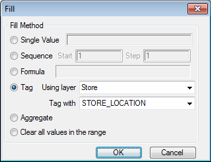 Choose Edit-Fill-Tag from
the menu. Choose Edit-Fill-Tag from
the menu.
-
Choose your point layer (e.g. stores) from the Using layer
drop-down list.
-
Choose the field from your point layer (e.g. store
name) to use to tag
each area from the Tag with
drop-down list.
-
Click OK. Maptitude fills the field
you highlighted with data from the chosen field in
the point layer.
-
Close the Dataview window.
-
Choose Map-Color Theme;
choose your new field for Field;
and choose List of Values for the
Method. Click OK.
Maptitude displays your postal/ZIP Codes shaded with colors based upon the closest point
location to each postal area.
|
Featured Maptitude Maps:
Sustainable Real Estate |
|
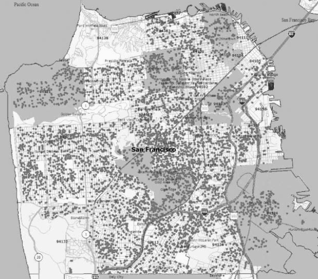
This month we showcase
Maptitude maps
published in the The Journal of Sustainable Real Estate,
and cited in The
Economist. In the first, "Wind
Farm Announcements and Rural Home Prices", the study
examines the announcement affect of a proposed wind farm
development on an 11,000-acre ranch in Northern Colorado
on surrounding rural housing prices. In the second, "Location
Efficiency and Default", a sample of over
40,000 home loans in Chicago, Jacksonville, and San
Francisco, was used to model the probability of loan
default.
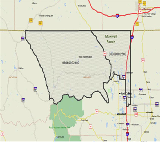
Wind Farm Announcements and Rural Home Prices (Steven
P. Laposa and Andrew Mueller)
Location efficiency and default (Stephanie
Rauterkus, Grant Thrall, and Eric Hangen)
If you would like to see your maps showcased here, please
contact
Caliper.
|
|

