Maptitude Help / Creating and Editing Geographic Files / Before You Start Editing
Before You Start Editing
Before you start editing a geographic file, there are a few things you need to know. This section provides a brief overview of some editing basics.
In this topic:
- Seeing and Saving Your Edits
- Intuitive Editing
- Feature IDs
- Length and Area
- Tabular Data
- Snapping
- Backing Up Your Work
Seeing and Saving Your Edits
While you are editing, features on the map are shown in different colors:
- Black is used for features you have added or modified
- Red is used for features you have deleted
The edits you make are not saved in the geographic file until you click the  in the Layer Editing toolbar. If you do not like the edits you made, or if you made a mistake, you can cancel the edits by clicking the
  . When you click to save your edits, Maptitude draws the map with the changes, using the normal colors.
Intuitive Editing
Maptitude has Active Topology™ map editing, a feature that helps you get the result you want when you edit a map. Active Topology map editing helps protect the structure of your geographic data while you edit. Instead of treating roads, boundaries, and areas as isolated shapes, Maptitude understands how connected map features relate to one another. When you move a shared intersection, reshape a boundary, or edit connected geography, Maptitude updates the related features so they continue to meet correctly. This helps preserve connectivity, adjacency, and shared geometry, reducing common GIS editing errors such as dangling line ends, gaps, overlaps, slivers, and open polygons.
The result is cleaner map data with less manual repair. Roads stay connected at intersections, shared boundaries stay aligned, and area features remain properly closed. For users editing streets, territories, service areas, ZIP Code-based geography, parcels, districts, or other connected map layers, Active Topology turns map editing from a fragile drawing task into a data-integrity workflow.
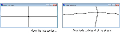
For example, suppose you are editing a road layer and move an intersection. As shown below, Maptitude automatically adjusts all of the streets that meet at the intersection.
Feature IDs
All map features have a unique identification number, or ID. Feature IDs are important because they are frequently used to join map features in a geographic file to tabular data stored in a database or spreadsheet.
Whenever you create a new feature, either by adding one or splitting an existing one into parts, Maptitude assigns each new feature a unique ID number. When you join features together, Maptitude keeps the ID of the first feature you picked.
Length and Area
When you edit line features, Maptitude always computes and stores the length of lines that you modify. The same is true with the area of an area feature. Whenever you add, modify, split, or join lines or areas, Maptitude automatically computes the lengths or areas of the features that have changed.
Tabular Data
Most geographic files include tabular data that describe the map features. When you edit a geographic file, the tabular data are also affected. When you delete a feature, any data for that feature are deleted. When you add a feature, the data will be the default field values of the table. For information on how to modify the default values, see To Modify the Structure of a Table.
When you split or join area features, Maptitude estimates the tabular data for the new features by using data for the original features. You can customize how these estimates are made. For more information, see Updating Tabular Data. If, however, you have data stored in a separate table that is linked to the map in a joined view, the data are not affected in any way by map editing.
Snapping
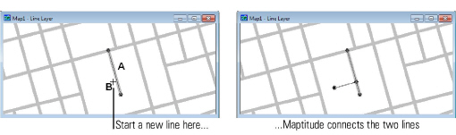
When you add line or area features using the geographic editing tools, Maptitude uses a feature called snapping to make sure that features meet up with each other the way you want. Whenever you mark a point on the map with the editing tools, Maptitude searches a small distance around the point to see if there are other features in the same layer. This distance is known as the snap tolerance. If there are other features, Maptitude snaps the features together. For example, suppose that you use the editing tools to add the line labeled A. When you click on point B to start adding a new line, Maptitude finds line A and makes sure that the two lines meet.
 |
NOTE: The default snap tolerance is 7 pixels. To change the snap tolerance, choose Edit>Preferences and enter new values on the System tab. You can set the snap tolerance based on a screen distance (in pixels) or based on a distance on the map (in any map units you choose). |
Here are two additional facts about snapping:
- Snapping only works with features that are being edited. If you want to snap to features that are already saved in a geographic file, simply select them with the modify tool before you begin editing.
- Snapping only works with features that are in the same layer. You cannot snap automatically to features in a different layer.
Backing Up Your Work
When you edit a geographic file, it is wise to back up your work from time to time. Maptitude has commands that let you create and restore archives of geographic files. See Archiving Geographic Files for more information.
©2026 Caliper Corporation