Maptitude Help / Geocoding / Locating Records by Coordinate
Locating Records by Coordinate
The Tools>Locate>Locate by Coordinate command creates points in a geographic file based on coordinate information stored in your data. The coordinates can be in degrees of longitude and latitude or in many other coordinate systems. To use the Locate by Coordinate command, your data file must include one field containing longitude or X-values and another field containing latitude or Y-values.
If your data file has fields with names such as Longitude and Latitude or X and Y, Maptitude displays the Locate by Coordinate dialog box automatically when you open the file. To learn more about longitude and latitude and other coordinate systems, see Projections and Coordinate Systems.
If your data file is a table with coordinate information in a database that can be accessed via Open Database Connectivity (ODBC), you can display that table as a point layer in a map. For more information, see Changing the Contents of a Map.
 To Locate Records by Coordinate
- Open a dataview of records to locate.
- Choose Tools>Locate>Locate by Coordinate to display the Locate by Coordinate dialog box.
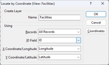
- If this is the first time that you are locating data, enter a name for the layer in the Name box.
- Choose whether to locate all records or a selection set from the Records drop-down list.
- Choose the field that contains unique IDs or choose to create new ID fields from the ID Field drop-down list.
- Choose the fields with coordinate data from the X Field and Y Field drop-down lists.
- If coordinate data are in a coordinate system other than longitude and latitude, click Coordinates to display the Import Coordinates dialog box. Choose the appropriate settings, and click OK to return to the Locate by Coordinate dialog box.
- Click OK. Maptitude does the following:
- Creates a new geographic file with one point for each record, or adds a point for each record to the existing geographic file.
- Adds the point layer to an existing map or creates a new map containing the point layer.
- Draws the map at a scale that shows the locations of all the points.
©2026 Caliper Corporation