Maptitude Help / Filters, Queries, and Selection Sets / Selecting Features by Location
Selecting Features by Location
A location question is used to find map features that are located in a particular area. For example, which customers live within 5 miles of a store? Maptitude lets you select features in one layer (the working layer) based on how close they are to, or how far they are from, features in another layer (the reference layer).
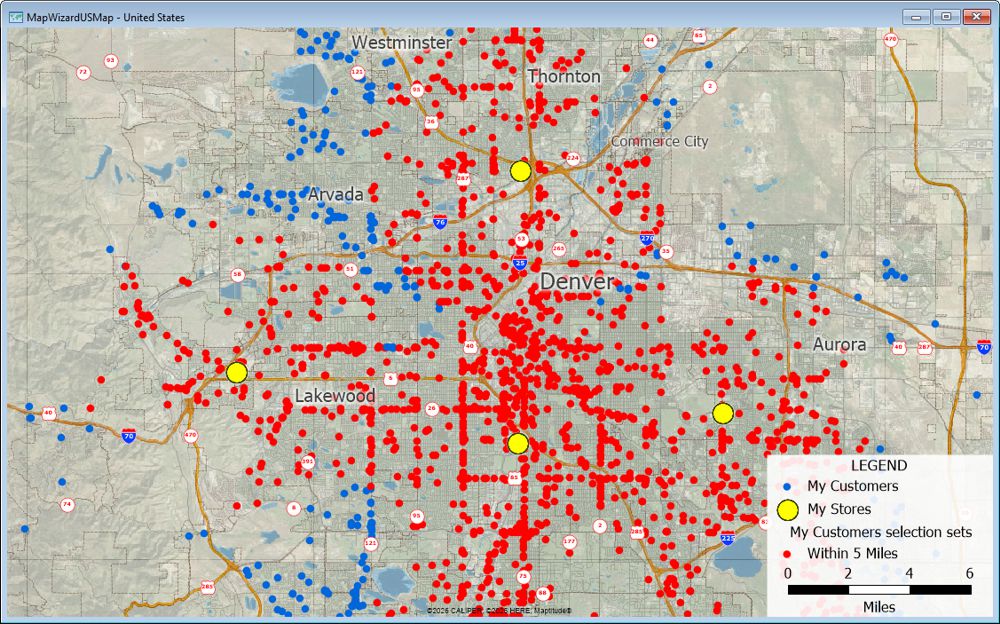
Customers are shown by default with a blue dot. The customers that are shown with red dots are all within five miles of one of the stores.
Maptitude also lets you select lines and endpoints of lines based on how they are connected. A line geographic file has two layers, one for the lines themselves and one for endpoints of the lines. You can select the lines that begin or end at selected endpoints, or the endpoints that are at the ends of selected lines.
 |
NOTE: The endpoint layer is normally hidden. You can show the layer by using the Map>Layers command. See To Change the Layers in a Map for more information. |
If the reference layer is a non-topological area layer, you have options for dealing with overlapping portions of those areas. For more information on non-topological area layers, see Using the Non-Topological Area Editing Tools.
Selecting features from one layer based on the location of features in another has many uses, for example:
| If you want to... | Select from the reference layer... | And then select... |
|---|---|---|
| Find airports near an Interstate highway | Interstate highways | Airports within 5 miles of the selected highways |
| Find customers in a sales territory | The sales territory of interest | Customers inside the selected territory |
| Find stores far from a distribution outlet | Distribution outlets | Stores not within 50 miles of the selected outlets |
| Find homes near schools | Schools | Homes within 0.5 miles of the selected schools |
 |
For a video tutorial see: (Internet connection required) • Working with Maptitude Selection Sets: Using the selection tools, selecting by location, selecting by attribute, combining selection sets, and computing statistics |
 To Select Features by Location
- Select one or more features in the reference layer, using any of the selection tools or selection commands.
- From the drop-down list on the Standard toolbar, choose the working layer — the layer whose features you want to select.
- Choose Selection>Select by Location to display the Select by Location dialog box.
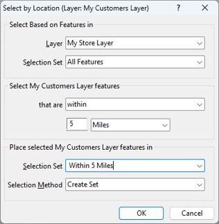
- Choose the reference layer from the Layer drop-down list.
- Choose whether to use all features in the reference layer or a selection set from the first Selection Set drop-down list.
- Choose a selection method from the drop-down list, and enter a distance if the method requires it. The options you see will vary depending on whether you are working with points, lines, or areas:
- Choose an existing selection set from, or type the name of a new selection set in, the Selection Set editable drop-down list.
- Choose how to store the results from the Selection Method drop-down list as follows:
| Method | Meaning |
|---|---|
| Create a set | Creates a new selection set with the name you type |
| Add to set | Adds records to an existing selection set |
| Remove from set | Removes records from an existing selection set |
| Subset | Selects only from those records that are already in an existing selection set |
- Click OK.
Maptitude selects records according to your settings, and highlights the result.
Try It Yourself: Selecting Features Using Another Layer
1. Choose File>Open Workspace or click  on the Standard toolbar, then open the RhodeIsland workspace in the Tutorial folder.
2. Click  in the Selection Tools drop-down on the Standard toolbar to activate the Select by Pointing tool and click on Providence County (the farthest North of the counties) to select it.
3. Right-click on the Place layer in the Display Manager and choose Make Working Layer.
4. Choose Selection>Select by Location to display the Select by Location dialog box.
5. Verify that County and Selection are chosen in the first two drop-down lists. Choose inside from the third drop-down list.
6. Click OK. Maptitude selects the places within Providence county and highlights them on the map.
7. Choose Selection>Select by Location again and choose not inside from the third drop-down list.
8. Click OK. Maptitude selects the places outside of Providence county.
9. Choose File>Close Workspace and click Don't Save to close the workspace without saving any changes.
©2026 Caliper Corporation