| Mapping, GIS, & Transportation Software Solutions |
| Mapping, GIS, & Transportation Software Solutions |
The Nationwide 2010 Data includes Census 2000 SF 1 and SF3 data for Census Tracts, which can be aggregated to higher levels such as County and State.
The Census SF 1 data contains variables that describe population, sex, age, race, Hispanic or Latino, household relationship, household type, group quarters population, housing occupancy, and housing tenure. There are 286 tables (8113 fields) for Census Tracts.
The Census SF 3 data contains variables that describe social, economic, and housing characteristics including school enrollment, educational attainment, marital status, grandparents as caregivers, veteran status, disability of the civilian noninstitutionalized population, residence, nativity and place of birth, region of birth of the foreign born, language spoken at home, ancestry, employment status, commuting to work, occupation, industry, class of worker, income, poverty status, units in structure, year structure built, rooms, year householder moved into unit, vehicles available, house heating fuel, occupants per room, value, mortgage status and selected monthly owner costs, selected monthly owner costs as a percentage of household income, gross rent, and gross rent as a percentage of household income. There are 405 tables (16,520 fields) for Tracts.
Available for other applications. Contact us to request the data in other GIS file formats (e.g., shapefile, KML, KMZ, GeoJSON).
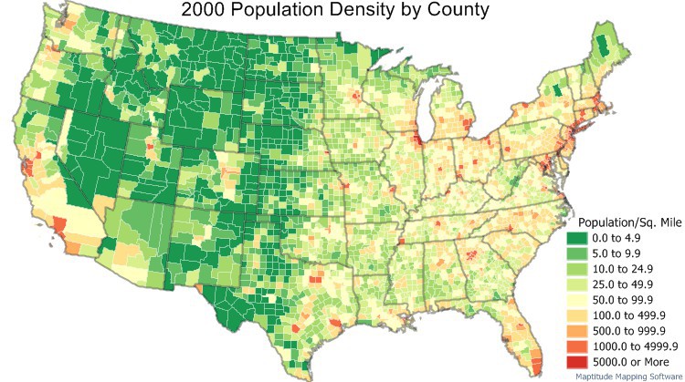
Population density by county from SF1 2000 Census data
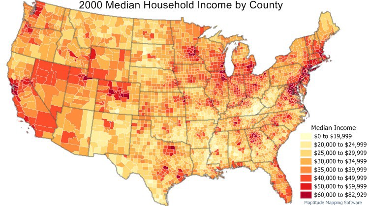
Median household income by county from SF3 2000 Census data
Home | Products | Contact | Secure Store