|


Learn more about how Maptitude can help your
organization:
Banking
Business Mapping
Community Development
GIS Software
GPS Mapping
Insurance
Law Enforcement
Marketing & Sales Mapping
Public Health
Real Estate
Redistricting
Satellite & Aerial Imagery
Street Mapping
World Mapping
|
Maptitude Training We believe
Maptitude is the most capable professional mapping
software on the market. To ensure that you can maximize
your investment, we designed Maptitude to be intuitive to Windows users
and easy to learn and use.
Maptitude Wizards guide you step-by-step
through standard tasks, and Maptitude ships
with a detailed User's Guide that contains numerous 60-Second
tutorials to assist with specific aspects of the software.
The
Maptitude
Learning Resources pages contain further aids, including a series of
videos that demonstrate the core features of Maptitude.
If you are new to Maptitude we recommend that you watch all of the
tutorials. They introduce many Maptitude techniques, tools, and
procedures. Caliper also offers several
training options:
•
Instructor-led
classroom training
•
Private Training
•
Web-Based Training
The next scheduled instructor-led training course will be May 10-12 in Newton, MA
(USA). The cost is
 $395 per day or $900 for all three
days. Advance registration is required.
Space is limited, so
register online as soon as possible. If you have any questions,
please call Maptitude Training (USA) at 1-617-527-4700, or send an e-mail to
sales@caliper.com. $395 per day or $900 for all three
days. Advance registration is required.
Space is limited, so
register online as soon as possible. If you have any questions,
please call Maptitude Training (USA) at 1-617-527-4700, or send an e-mail to
sales@caliper.com. |
Featured Data Product:
Quarterly ZIP Codes (USA)
Do you make business decisions based on postal data? If so, Caliper
quarterly ZIP Code updates will ensure you are using the latest data. The
5-digit ZIP Code Boundaries Data CD contains a nationwide area database
with ZIP Codes for all 50 states, the District of Columbia, Puerto Rico,
and the territories. It also includes a point database of ZIP Code
centroids for the entire country. Caliper updates this file quarterly to
provide up-to-date access to United States Postal Service changes.
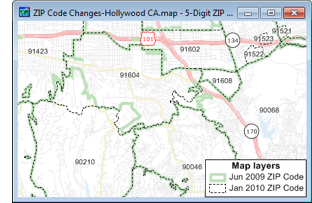
Price: $195. Please call
Caliper (1-617-527-4700) to place your order.
|
|
Tech Tip:
Mapping Tract Data with the Map My Own Data Wizard
The Map My Own Data Wizard in Maptitude 5.0 accepts tables
with US Census Bureau Full Tract Specification codes (i.e., the Tract codes as
displayed in the Tract layer dataview). You can easily
create a map showing Tract boundaries, and use it to display
information from your data file.
1. Choose File-New,
choose Map from the New File dialog box,
and click OK. This brings you to the Create-a-Map Wizard.
2. Choose the
Map of my own data option.
3. Browse for the
Excel file containing your data. Choose the sheet in the
Excel
workbook that contains your data and click OK.
4. Click Next in the
Create-a-Map Wizard.
5. Choose the
Show Tract Boundaries with your data attached
option and click Next.
6. Choose a theme type and field to use
and click Next.
7. Click Finish.
Maptitude creates a
map of your Tract data.
|