Maptitude Newsletter
  January 2012
Upgrade to Maptitude 6.0
Connect with Us

Phone 1.617.527.4700
Email sales@caliper.com
Maptitude Website Email a Request for a Demo
Maptitude Pricing and Ordering Join Us on Yahoo Groups
Follow Maptitude on Facebook
Follow Maptitude on You Tube
Follow Maptitude on Twitter

Maptitude Solutions

Learn more about how Maptitude can help your organization:

Banking GIS

Business Mapping

Census Data Mapping

Community Development

Election Management

Enterprise GIS

GIS Software

GPS Mapping

Insurance Mapping

Law Enforcement GIS

Marketing & Sales Mapping Software

Public Health Mapping

Real Estate Mapping

Redistricting

Satellite & Aerial Imagery

Street Mapping

Territory Mapping

Web Mapping

World Mapping

Maptitude 2012 Is HereMaptitude Spotlight:

Maptitude 2012 Released  

Maptitude 2012 is a major new release of Caliper Corporation's award-winning GIS software. Maptitude remains the most competitively priced professional mapping software available.

Maptitude 2012 ships with the most detailed and accurate U.S. data and demographics ever included.

The new features and enhancements enable you to create the maps you need faster, with higher accuracy, more attractively, and with better analytical tools. More...


Maptitude Classroom Training:
Updated Curriculum for Maptitude 2012

Maptitude Training DatesThe next scheduled instructor-led training courses will be  January 23-25 in Newton, MA (USA). Advance registration is required.

The new and updated curriculum reflects the features in Maptitude 2012.

Space is limited, so register online as soon as possible. If you have any questions, please call Maptitude Training (USA) at +1 617-527-4700, or send an e-mail to sales@caliper.com.


Caliper also offers several training options:  

 • Instructor-led classroom training
 • Private training
 • Web-based training

 • Free Learning Resources


Free Mapping Resources:

This month's free resource is a series of new training videos for Maptitude 2012:

 • Creating Masks
 •
Creating Network Bands
 •
Finding Shortest Paths

 
Did You Know?
Context Sensitive Menus  

Did You KnowIn Maptitude when you click the right mouse button, a context-sensitive menu is displayed. The menu choices in the context-sensitive menu relate to the item clicked on, such as a map, legend, or the Display Manager.

Maptitude in the News:

MapCruzin: Caliper Releases Maptitude 2012

GEOUser: Responding to Disaster: Lessons Learned

DelmarvaNOW.com: Wicomico County steps toward district changes

KTNF950: Minneapolis readies web pages for input on redistricting

More...
Featured Data Product:
12-Month U.S. ZIP Code Layer Subscription

ZIP Code MapThe 12-Month U.S. ZIP Code Layer Subscription is now available for purchase. The subscription includes four quarterly updates to the U.S. 5-digit ZIP Codes Data Disc.

Do you make business decisions based on postal data? If so, Caliper quarterly ZIP Code updates will ensure you are using the latest data. The U.S. 5-digit ZIP Codes Data Disc contains a nationwide area database with 5-digit ZIP Code boundaries for all 50 states, the District of Columbia, Puerto Rico, and the territories. It also includes a point database of 5-digit ZIP Code centroids and an area database of 3-digit ZIP Code boundaries for the entire country. Caliper updates this file quarterly to provide up-to-date access to United States Postal Service changes.

The Data CD ships with Census ACS demographic data at no additional cost, including fields for income, age, race, gender, and ethnicity. 

Price: US$795. Place your order online at the Caliper Store.

Tech Tip:
Creating Drive Time Zones by Clicking on a Map

Drive Time BandsMaptitude 2012 provides the most accurate drive-time zone calculations.

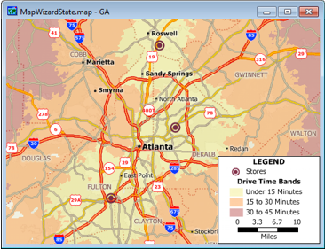
The Network Bands tool has been completely overhauled in Maptitude 2012 and, among many other changes, now allows origins to be chosen by simply clicking on the map. 

The following steps walk you through this task:

1. Choose File-New, choose Map from the New File dialog box, and click OK. This brings you to the Create-a-Map Wizard.

2. Choose the General Purpose Map option, then choose A County, type the name of a county (e.g., Cook IL) in the Name box, click Next, and click Finish.

3. Choose Tools-Routing-Network Bands to display the Network Bands toolbox. 

4. Click Network Bands Point Tool in the Network Bands toolbox to activate the Click Origin Points tool.

5. Click on three different locations on the map. Maptitude places symbols at each of the clicked points.

6. By default, the toolbox creates drive-time bands based on the Travel Time field in the street layer. Type 5 in the Every edit box and 15 in the Max edit box to create three 5-minute network bands around each of the locations where you clicked.

7. Click Create Bands Button in the Network Bands toolbox. Maptitude creates the bands and adds them to the map along with a color theme to illustrate the drive times. Any portion of the map that is not covered by a band is greater than a fifteen-minute drive from the clicked locations. 

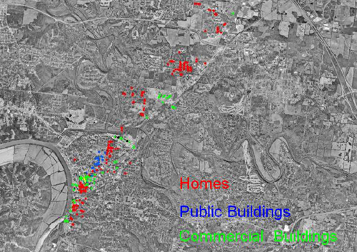
Featured Maptitude Maps:
Tornado Damage Map

This month we showcase a Clarksville/Montgomery County (TN) GIS Center map created with an older version of Maptitude that highlights the utility of Maptitude in disaster response:

Tornado Damaga Map

Map of path of tornado and location of homes and buildings damaged or destroyed

If you would like to see your maps showcased here, please contact Caliper.


Previous Issue (December 2011)