Maptitude Newsletter
  July 2012
Upgrade to Maptitude 6.0
Connect with Us

Phone 1.617.527.4700
Email sales@caliper.com
Maptitude Website Email a Request for a Demo
Maptitude Pricing and Ordering Join Us on Yahoo Groups
Follow Maptitude on Facebook
Follow Maptitude on You Tube
Follow Maptitude on Twitter

Maptitude Solutions

Learn how Maptitude can help your organization:

Banking GIS

Business Mapping

Census Data Mapping

Community Development

Election Management

Enterprise GIS

GIS Software

GPS Mapping

Insurance Mapping

Law Enforcement GIS

Marketing & Sales Mapping Software

Public Health Mapping

Real Estate Mapping

Redistricting

Satellite & Aerial Imagery

Street Mapping

Territory Mapping

Web Mapping

World Mapping

Maptitude Mapping Software 2012 is HereMaptitude Spotlight:

Special Offer: US$495 Discount With Maptitude Purchases & Upgrades!

The 12-month USA ZIP Code subscription and the 2010 Census Block boundaries are available with a $495 discount when ordered together with Maptitude! For a limited time, Maptitude purchases and upgrades can be bundled with these discounted USA data!

Don't miss out on these discounted combo Packages that include updated demographics, including U.S. Census 2010 data!

Please visit our online store to order. Volume discounts are available by calling U.S. Sales at +1 617-527-4700. New Maptitude bundle purchases are US$995; Upgrades are US$695. A US$495 discount!

Limited time offer, valid until July 31st (2012).

Special Offers
Save $495 on Maptitude + ZIP Code Subscription
Save $495 on Maptitude + Block Layer


Maptitude Classroom Training:
Updated Curriculum for Maptitude 2012

Maptitude Mapping Software Training Dates

The next scheduled instructor-led training courses will be July 23-25 in Newton, MA (USA) and September 24-26 in Washington, DC (USA).

Advance registration is required.

The new and updated curriculum reflects the features in Maptitude 2012.

Space is limited, so register online as soon as possible. If you have any questions, please call Maptitude Training (USA) at +1 617-527-4700, or send an e-mail to sales@caliper.com.


Caliper also offers several training options:  

 • Instructor-led classroom training
 • Private training
 • Web-based training

 • Free Learning Resources


Free Mapping Resources:

This month's free resource is a new training video for the Maptitude 2012 Canada Package:

 • Maptitude 2012 for Canada Video

 
Did You Know?
Layer Databases  

Maptitude Mapping Software Did You KnowEach layer in a map is a geographic database. You can right-click on a layer in the Display Manager & choose New Dataview to view the layer attributes. Each record is a feature in the map, and every feature in the map has a corresponding entry in the table. For example, you can right-click on a record and choose Zoom, to find the feature in the map

Maptitude News & Press:

Caliper US ZIP Codes with Business, Census, & Land Use Data  

Caliper Offers New Australia Data for Use with the Latest Maptitude   

DirectionsMag.com: Product Overview: Maptitude Version 2012

SlashGeo.org: Product Overview: Maptitude Version 2012  

More Maptitude News...

Featured Product:
ZIP Codes (USA) with 2010 Census Demographics
NEW: Now Includes Business Counts and Urban-Rural-Commuting Types

Sample map of ZIP Codes with the new business count data

New for July 2012, the ZIP Code data now include the number of businesses by detailed industry type (Retail, Finance, etc.), along with numbers of employees and annual payrolls. The ZIP Codes are also classified by their rural-urban commuting characteristics.

If you make business decisions based on postal data, Caliper quarterly ZIP Code updates will ensure you are using the latest information. The 5-digit ZIP Code Boundaries Data contains a nationwide area database with ZIP Codes for all 50 states, the District of Columbia, Puerto Rico, and the territories. It also includes a point database of ZIP Code centroids and 3-digit ZIP Code Areas for the entire country. Caliper updates this file quarterly to provide up-to-date access to United States Postal Service changes.

The product comes with Census demographic data at no additional cost, including fields for household income from the 2010 5-year American Community Survey and new fields for age, race, gender, Hispanic origin, households by type, and housing tenure from the 2010 Census.

The 3-digit and 5-digit ZIP Code areas include 2009 ZIP Code Business Patterns (ZBP) NAICS codes, employees, and payroll data, plus Rural-Urban Commuting Area (RUCA) codes.        

Price: US$195. Place your order online at the Caliper Store Now.

Buy Maptitude Mapping Software Data
Tech Tip:
Using Image Fill Styles

Maptitude map solid fills using Canada and USA flags

Maptitude provides many tools that allow you to customize the visualization of your data (see the training video). These include modifying the style of point, line, and area features.

The area image fill style feature allows area shading to use any picture file including those in formats such as GIF, ICO, TIF, BMP, JPG, PNG, and EMF. And, in celebration of the 4th of July, we will be draping the US in the American flag! The same process can be followed for Canada and France if you are celebrating Canada or Bastille Day! 

The following steps walk you through this task:

1. Choose File-New, choose Map from the New File dialog box, and click OK. This brings you to the Create-a-Map Wizard.

2. Choose the General Purpose Map option, and choose the entire U.S..

3. Click Next> and click Finish.

4. In the Display Manager click on the style sample to the left of the State layer item.

5. Choose the Image... from the bottom of the Fill Style drop-down list.

6. Outside of Maptitude, in your web browser (e.g. Chrome, Firefox, Internet Explorer), browse to: https://www.caliper.com/graphics/USA_Flag.png.

7. Right click on the image displayed in the browser window and choose Save Image/Picture As and save the image file to a folder on your computer.

8. Go back to Maptitude and browse to the file you just downloaded and click Open.

9. In the Image Fill Style Settings dialog box change the size to be 25% and click OK to return to the Style dialog box.

10. Change the Fill Opacity to 20% and click OK. Maptitude displays an image based fill style for the State layer.

Featured Maptitude Maps:
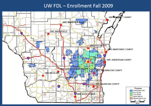
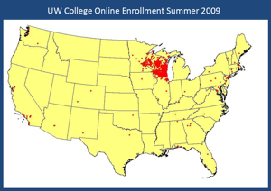
UW Colleges: Patterns of Enrollment and Cultural Diversity

This month we showcase Maptitude maps of University of Wisconsin enrollment and cultural diversity. The maps were created by Jim McCluskey at the Department of Geography and Geology.

UWFDL Enrollment by ZIP Code     UW Online Enrollment


If you would like to see your maps showcased here, please contact Caliper.


Previous Issue (June 2012)