Maptitude Help / Changing and Customizing Maps / Using Features Display Settings
Using Feature Display Settings
Feature display settings are a way to design styles and labels for groups of features within a layer. For example, you can use feature display settings to show different classes of highways with different line styles and highways shields, or to show different types of landmarks with different symbols. You can autoscale feature display settings so that sets of features are shown only with a range of scales.
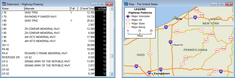
Assign styles to the CCSTYLE field in a highway layer to make the layer display like the map on the right. All highway segments with the same value will use the same style and label settings.
 |
TIP: Most of the geographic files included with Maptitude use feature display settings to display classes of features. Use the Feature Display Settings dialog box or the Display Manager to see or modify the predefined feature settings. |
Feature display settings are based on an integer field named CCSTYLE that can contain codes between 1 and 255 for a 1-byte integer or between 1 and 32,767 for a 2- or 4-byte integer. Each code can have a feature display setting. A feature display setting can be active (used when drawing the layer) or inactive. Line geographic files can have feature display settings for both the lines and the nodes.
The name for the ccstyle field can be upper, lower, or mixed case. The most efficient field to use is a 1-byte integer in a binary file. You could also use any integer field either named ccstyle or with a column heading of ccstyle. You can also use an integer field that has a lookup table, as long as you base your feature display settings on the codes, not the values.
A code in the ccstyle field does not need to have a feature display setting; features with that code will be displayed using other settings for that layer. You can also assign feature display settings for codes that do not currently appear in the ccstyle field; once there are features with those codes, they will be shown with those feature display settings. If you do not see your feature display settings, remember that themes and selection sets override them in priority.
Feature display settings are data driven; if you change a code for a feature, the next time the map is redrawn the feature will be displayed using the new feature display setting. Unlike themes, feature display settings also control label settings.
Feature display settings are saved when you save a map. When you modify feature display settings, you can also save them in a feature display settings (.ST0, .ST1, or .ST2) file or in a style (.STY) file. For more information on saving settings in a style file, see Saving Settings for a Geographic File.
 To Manage Feature Display Settings
- Choose a layer for which there is a ccstyle field from the drop-down list on the Standard toolbar.
- Choose Tools>Editing>Feature Display to display the Feature Display Settings dialog box.
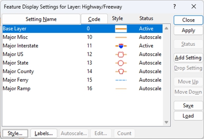
- Make changes to the feature display settings as follows:
| To do this... | Do this... |
|---|---|
| Add a feature display setting | Highlight a feature display setting in the scroll list. Maptitude will base the new feature display setting on one that is highlighted. Click Add Setting. Maptitude displays the Edit Display Setting dialog box. Edit the code, the name for the setting, and an optional description in the edit boxes, and click OK. Maptitude adds the new feature display setting and highlights it. |
| Edit a feature display setting | Highlight the feature display setting and click Edit. Maptitude displays the Edit Display Setting dialog box. Edit the code, the name for the setting, and an optional description in the edit boxes, and click OK. Maptitude updates the feature display setting in the scroll list. |
| Load feature display settings | Click Load. The current feature display settings will be replaced by those in the feature display settings (.ST0, .ST1, or .ST2) file. |
| Change the style for a feature display setting | Highlight the feature display setting and click Style. Modify the style settings (see Using Styles for more information, and click OK to return to the Feature Display Settings dialog box. |
| Change the labels for a feature display setting | Highlight the feature display setting and click Labels. Modify the label settings (see Using Labels for more information), and click OK to return to the Feature Display Settings dialog box. |
| Display a feature display setting at certain scales | Highlight the feature display setting and click Autoscale. Enter a minimum and maximum scale at which to display the features in the feature display setting and click OK. For more information on autoscaling, see Controlling Layers Automatically with Autoscale. |
| Sort the feature display settings by name | Click Setting Name. |
| Sort the feature display settings by code | Click Code. |
| Change the order of feature display settings | Highlight one or more feature display settings, then click Move Up or Move Down to change their position in the list. |
| Change the status of feature display settings | Highlight one or more feature display settings, then click Status to change the display status between Active and Inactive. |
| Drop a feature display setting | Highlight the feature display setting and click Drop Setting. Maptitude displays the Confirm dialog box. Click Yes to drop the feature display setting or No to keep it. |
| Count the number of features with a code | Highlight the feature display setting and click Feature Count. Maptitude counts the features with the feature display setting’s code and displays the results. Click OK to close the Note dialog box. |
| Try out the current feature display settings | Click Apply. Maptitude displays the map with the current feature display settings. |
| Save the settings to a feature display settings file | Click Save. The current feature display settings will be saved to a feature display settings (.ST0, .ST1, or .ST2) file. |
- Click Close.
Maptitude displays the map using the active feature display settings.
©2026 Caliper Corporation