Maptitude Help / Introducing Maptitude / Starting Maptitude
Starting Maptitude
When you first start Maptitude, the program displays the Home dialog box:
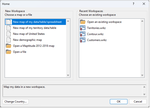
The Home dialog box has several options for creating new workspaces:
| Option | What it does... |
|---|---|
| New map of my data/table/spreadsheet | Choose this option if you want to create a map that helps you visualize data stored in a table/spreadsheet/file and visualize it on a map. When you click OK, Maptitude will prompt you for the location of the file to use and launch Create-a-Map Wizard™ to guide you the rest of the way. See Mapping My Own Data for more information. |
| New map of my territory data/table | Choose this option if you want to create a map of territories (such as sales territories or school districts). When you click OK, Maptitude will launch the Territory Wizard to guide you through the steps of creating a territory layer. See Creating Territories for more information. |
| New map of {country name} | Choose this option if you want to create a map of a particular location within the chosen country. If you have more than one Country Package installed, you can click Change Country to choose a different country to use. When you click OK, Maptitude will launch Create-a-Map Wizard where you can specify the area to display on the map. See To Use Create-a-Map Wizard to Create a Country Map for more information. |
| New demographic map | Choose this option if you want to create a map that uses some of the demographic data that are included with Maptitude. The available maps will depend on what country package that you have installed, but may include options such as population, income, housing, age, and race. When you click OK, Maptitude will launch the Map Librarian where you can specify the map, level of detail, and location to display. See Using the Map Librarian for more information. |
| Open a Maptitude 2012-2018 map | Choose this option if you want to see a Maptitude .MAP file that you created in an earlier version of Maptitude in your workspace. When you click OK, Maptitude will prompt you for the .MAP file to import into your workspace. |
| Open a file | Choose this option if you want to create a map using one or more Caliper geographic files or other geographic format files such as MapPoint .PTM or Esri Shapefiles. When you click OK, Maptitude will prompt you for the file to open in your workspace. See Using Other Geographic Files for more information. |
You can also open any saved or recently used workspaces by choosing an option in the Recent Workspaces list and clicking OK.
 |
NOTE: You can choose whether or not to display the Home dialog box by default by choosing Edit-Preferences and using the Display the Home window on startup option on the System tab. |
 |
For a video tutorial see: (Internet connection required) • Creating a General Purpose Overview Map with Maptitude: Creating a general purpose map with Create-a-Map Wizard or the Map Librarian • Creating a Maptitude Map Using Your Own Data: Using Create-a-Map Wizard to locate, map, and analyze data stored in an Excel spreadsheet |
©2026 Caliper Corporation