|
September 2017 Newsletter |
|||
|
|||


Website | Contact Us | Pricing | Live Demo | Free Trial | Reviews
Want More Free Premium Data?
Public Land Survey System (PLSS) for Maptitude 2017!
The
Land Ordinance of 1785 established the
Public Land Survey System, also known as
the Township and Range system. Today the
Bureau of Land Management maintains the
Survey as a way to accurately categorize
large areas of the Continental US. Area
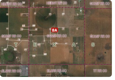
layers for the PLSS and for the Texas
Survey System (TXSS) are now
downloadable for free for Maptitude 2017
users only. Don't have Maptitude 2017? Purchase or upgrade to Maptitude 2017 to use this premium data.
The PLSS and TXSS are used:
- for administering lease programs by state oil and gas commissions
- for right of access management programs
- for local government parcel mapping
- for researching the ownership of Mineral Rights under a person's property
- for locating oil or gas wells by petroleum geologists
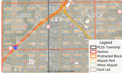
The downloaded layers can be added to any Maptitude 2017 map. The PLSS divides large areas of the USA into townships and sections (First Divisions and Second Divisions). The Texas Land Survey Layer splits the state into tracts, sections, and labors.
![]()
![]()
 |
"Maptitude has been an important tool for showing the geography of a variety of facilities and parameters, from rig trends by state, to patent trends by metro area, to the location of important infrastructure installations. Being able to illustrate and map these elements with Maptitude was essential for the analysis and, in addition, the software is backed up with outstanding support if needed." Charlotte Batson Petroleum Engineer / Shale Oil & Gas Consultant |
Featured Map:
Natural Gas Consumption & Production by State (USA)
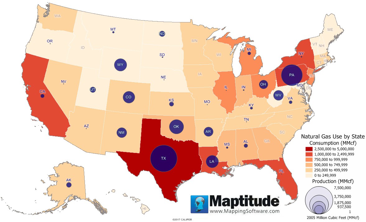
This Maptitude map shows production and consumption of natural gas by state measured in million cubic feet (MMcf). The largest producers of natural gas are Texas (7,071,203 MMcf), Pennsylvania (4,759,441 MMcf), and Oklahoma (2,336,234 MMcf). Six other states (WY, LA, CO, WV, NM, and AR) also produced over 1,000,000 MMcf of natural gas in 2015. The largest consumers of natural gas are Texas (4,139,551 MMcf), California (2,309,759 MMcf), and Louisiana (1,465,495 MMcf). Three other states (NY, FL, and PA) also consumed over 1,000,000 MMcf.
Tech Tip:
How Do I Download the Free U.S. PLSS & TXSS Layers for Maptitude 2017?
The PLSS and TXSS map layers for Maptitude 2017 are accessible as a free download. In this tech tip we describe how to install the layers and add them to a map.
Tricks & Tips:
Adding Map Background Imagery to a Map
When you have added one or more PLSS or TXSS layers to your map as described in the above Tech Tip, you can then add aerial background imagery to add context for those layers. This can be particularly helpful in more remote areas.
Using the Map menu (Map > Imagery) you can add photos and topographic images for the location you are looking at. Use the Display Manager to turn the image layers on and off or change their level of contrast or transparency.
Learning Maptitude:
Webinars and Training Dates for Maptitude 2017
 |
Upcoming Training: |
|
 |
2017 Webinars (Free)! |
![]()
![]()
| News | ||
|
International Mapping:
| www.caliper.com |
Copyright ©2017, Caliper Corporation. All Rights Reserved. |