GIS metadata refers to essential information about a geographic information system (GIS) dataset, including its source, quality, content, and other characteristics. This metadata serves as a comprehensive documentation of the spatial data, providing critical context for its proper understanding and usage. GIS metadata ensures data transparency, allowing users to assess the dataset's reliability, accuracy, and limitations before incorporating it into their analyses.
Metadata in GIS plays a pivotal role in data discovery and evaluation. It enables users to efficiently search for relevant spatial data, assess its suitability for specific applications, and determine whether it aligns with their research or project needs. By providing a standardized format for documenting essential information, GIS metadata facilitates the integration of disparate datasets, promoting interoperability and data sharing among different GIS platforms and users.
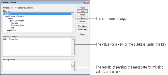
The Maptitude metadata manager helps you structure your geodatabase metadata
Metadata are data about data. Maptitude lets you view, create, and edit metadata associated with geographic files. The metadata are structured using the Federal Geographic Data Committee (FGDC) standard. For more information, see Content Standard for Digital Geospatial Metadata, Publication FGDC-STD-001-1998, available on the FGDC website (www.fgdc.gov). The structure has keys, subkeys, and values. Each key either has a value or has one or more subkeys. The subkeys themselves are keys which can have values or subkeys.
You can create a new metadata file from scratch. Maptitude knows the rules for building metadata using the FGDC standard and will assist you with lists of the valid subkeys for a key, including those that can and cannot be repeated. Maptitude can also assist you in two ways, by:
If you combine these two methods, Maptitude makes it much easier to document a set of files with similar metadata values.
Maptitude Mapping Software gives you all of the tools, maps, and data you need to analyze and understand how geography affects you and your business.
Learn More Free Trial Free for Students/Teachers