December 2025:
Live Music Venues

November 2025:
Thanksgiving Recipes

November 2025:
NYC Mayoral Election

November 2025:
Pediatricians by County

October 2025:
Pediatricians by State

October 2025:
Italian Restaurants

October 2025:
Motorcycle Ownership

October 2025:
Seafood Restaurants

October 2025:
German Ancestry

September 2025:
Public Land

September 2025:
Mexican Restaurants

September 2025:
Peanut Production

August 2025:
Tallest Roller Coaster by State

August 2025:
Roller Coasters by State

August 2025:
California Congressional Districts

August 2025:
Texas Congressional Districts

August 2025:
Bowling Alleys

August 2025:
Craft Breweries

August 2025:
Disc Golf Courses

July 2025:
Cincinnati Skyline Chili

July 2025:
Restaurants

July 2025:
Lottery Sales

July 2025:
Lottery Prizes vs. Spending

July 2025:
Tattoo Parlors by State

July 2025:
French Ancestry

July 2025:
7-Eleven Stores/Subsidiaries

July 2025:
"Sushi" Restaurants

June 2025:
Beauty Industry

June 2025:
Airport Accessibility
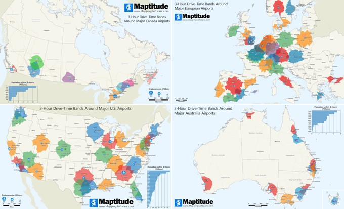
June 2025:
Corn Production by State

June 2025:
Massachusetts Dunkin Donuts

June 2025:
Egg Production by State

May 2025:
Burger Restaurants by State

May 2025:
Distilleries by State

May 2025:
Closest 2025 WNBA Team

April 2025:
Insurance Coverage by Age

April 2025:
L.A. County Home Values

April 2025:
Scottish Ancestry

March 2025:
Nearest Baseball Park

March 2025:
Irish Ancestry

March 2025:
Popular Cereal Searches

March 2025:
Cereal Grain Shipments

February 2025:
Pizza Restaurants

February 2025:
Pizza Chains

January 2025:
Movie Theater Access

January 2025:
Bagel Stores

January 2025:
Pharmacists

January 2025:
Health Club Concentration

January 2025:
Fitness Chains

December 2024:
Bacon Spending

December 2024:
Maple Syrup Production

December 2024:
Popular Brownie Searches

December 2024:
Popular Cookie Searches

December 2024:
Dog Ownership

November 2024:
Mapping Thanksgiving Meal

November 2024:
Fast Food by State

November 2024:
Veterans by State

November 2024:
Most Searched Sandwich

November 2024:
Bank Deposits by State

November 2024:
Bookstores by State

October 2024:
Closest NBA Team

October 2024:
Cat Ownership

October 2024:
Indigenous Population

October 2024:
Italian Ancestry

September 2024:
Farm Area

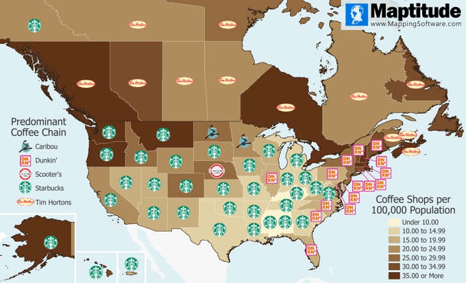
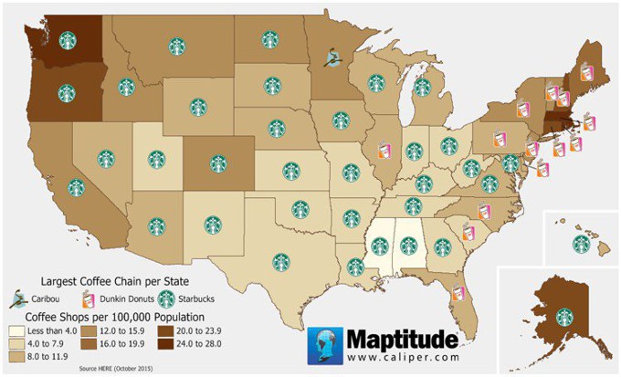
September 2024:
Coffee Shops

August 2024:
IHOP vs. Waffle House Market Share

August 2024:
Waffle Restaurants

August 2024:
Senior Citizen Population

August 2024:
UK & Ireland Petrol Stations

August 2024:
Beer Production

July 2024:
Wine and Cheese Spending

July 2024:
Fried Chicken Chain Restaurants

July 2024:
Home Improvement Stores

June 2024:
Market Share of Lowes vs Home Depot

June 2024:
Closest WNBA Team

June 2024:
U.S. Concentration of Donut Stores

June 2024:
Fishing License Fee by State

June 2024:
Closest MLS Soccer Stadium

June 2024:
Closest 2024-25 Premier League Club

June 2024:
Closest NHL Team (2024-25)

May 2024:
Sales Territory Hierarchy Examples

April 2024:
Geographical Hierarchy of ZIP Codes

April 2024:
Census Regions and Divisions

April 2024:
U.S. Concentration of Pretzel Stores

April 2024:
State Income Taxes per Capita
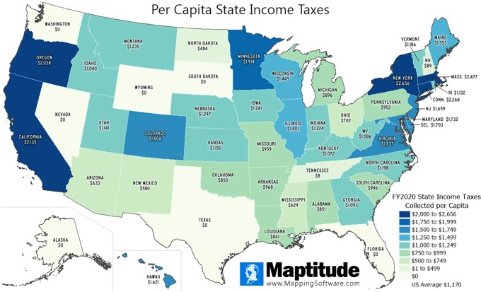
April 2024:
Average Download Speed

March 2024:
Closest MLB Stadium by Drive Time

March 2024:
Closest Minor or Major League Baseball

February 2024:
Wine Production by Country

February 2024:
Bonne Projection Map

February 2024:
U.S. Frozen Yogurt Stores

February 2024:
Concentration of Frozen Yogurt Stores

January 2024:
Business Locations 2024 Update

January 2024:
USPS Carrier Routes: Businesses Served

December 2023:
Top UK Franchises 2023

December 2023:
Market Share Comparison

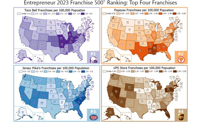
November 2023:
Entrepreneur Top Franchises 2023
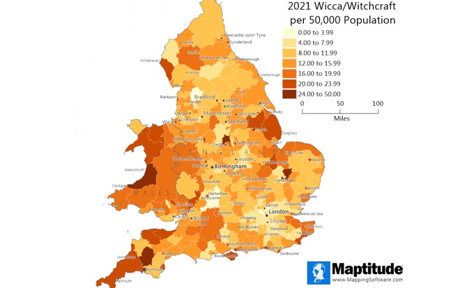
October 2023:
Wicca and Witchcraft Population
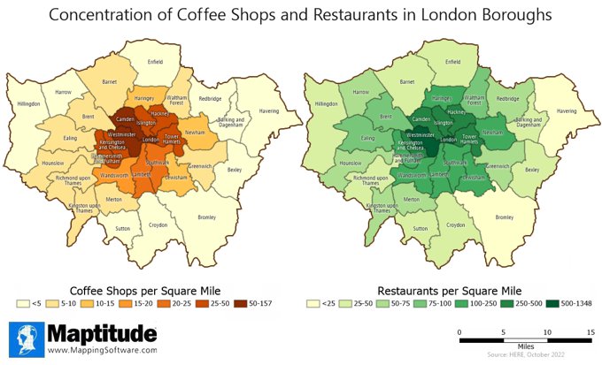
October 2023:
London Restaurants and Coffee Shops
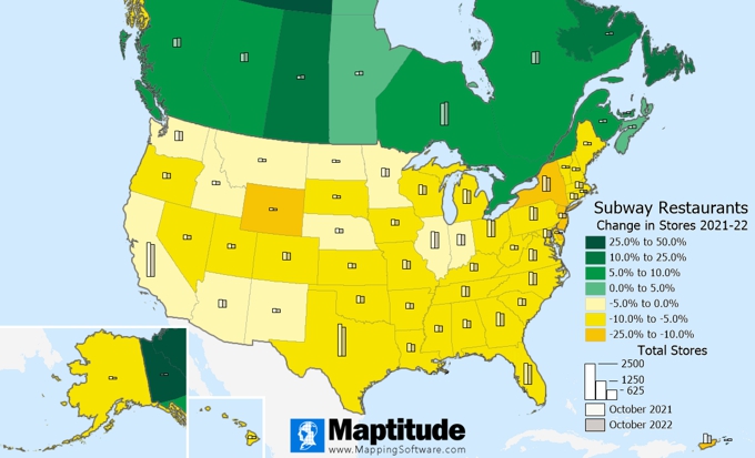
October 2023:
Subway Restaurants
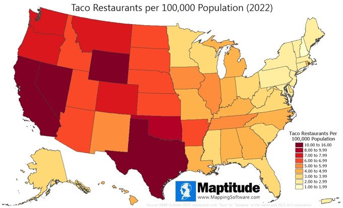
October 2023:
U.S. Concentration of Taco Restaurants
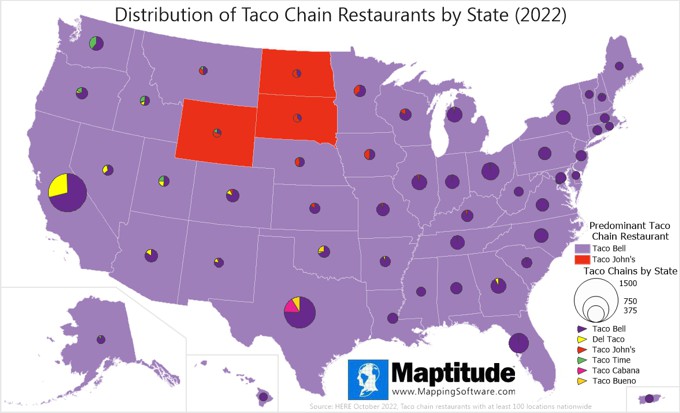
October 2023:
U.S. Taco Chains
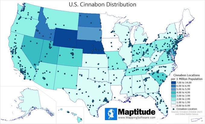
October 2023:
U.S. Cinnabon Stores
September 2023:
Beer Consumption

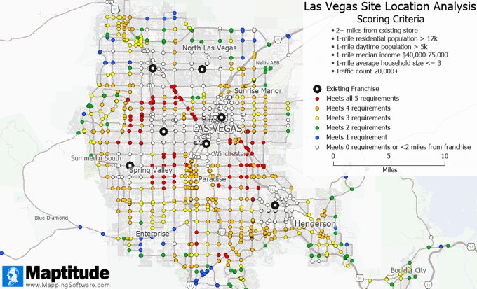
September 2023:
Site Requirement Analysis of Street Intersections
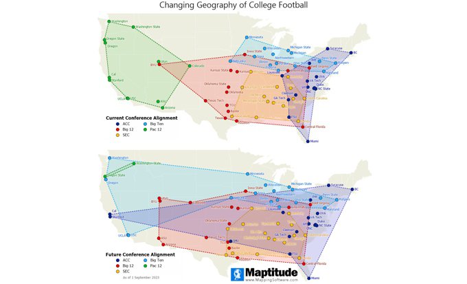
September 2023:
College Fottball Conference Realignment
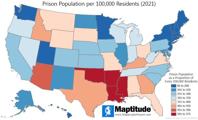
July 2023:
Prison Population by State
June 2023:
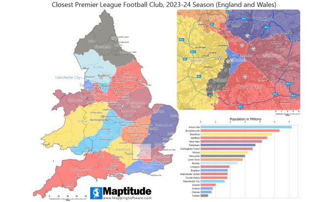
Closest Premier League Club
June 2023:
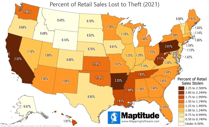
Retail Sales Losses to Theft
April 2023:
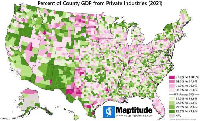
GDP from Private Industries
February 2023:
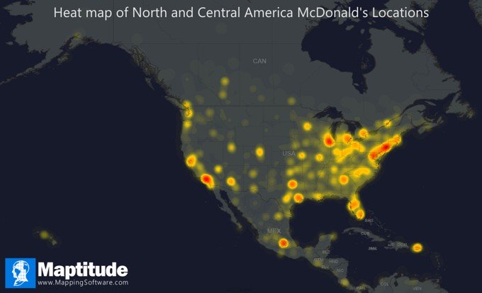
McDonald's Heat Map
December 2022:
North American Ski Resorts

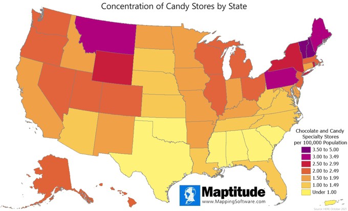
October 2022:
Candy Stores by State
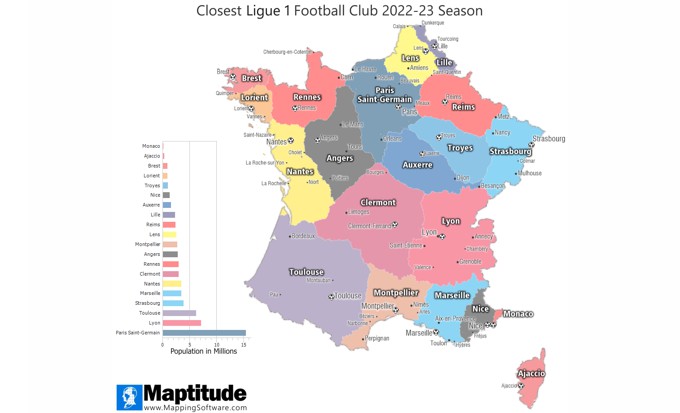
September 2022:
Closest Ligue 1 Club
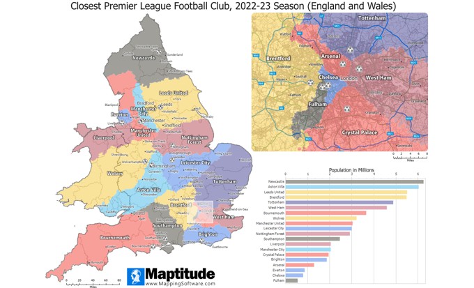
September 2022:
Closest Premier League Club
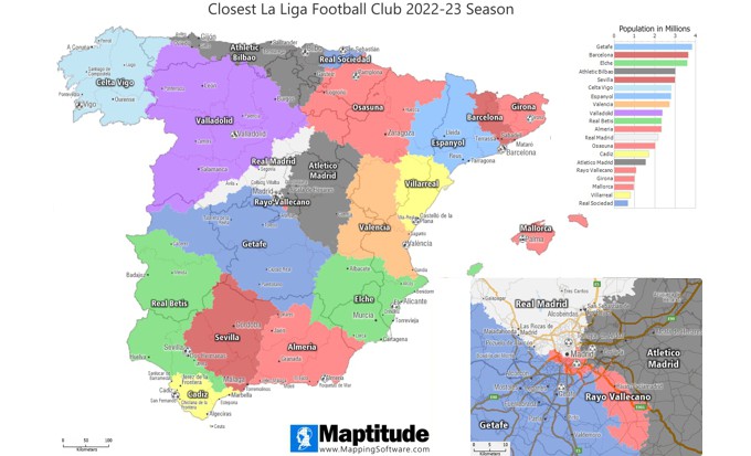
September 2022:
Closest Spanish La Liga Club
September 2022:
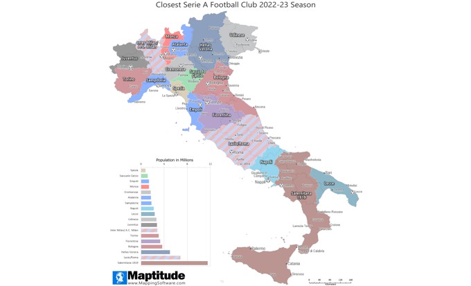
Closest Italian Serie A Club
September 2022:
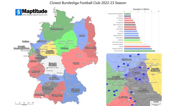
Closest Bundesliga Club
September 2022:
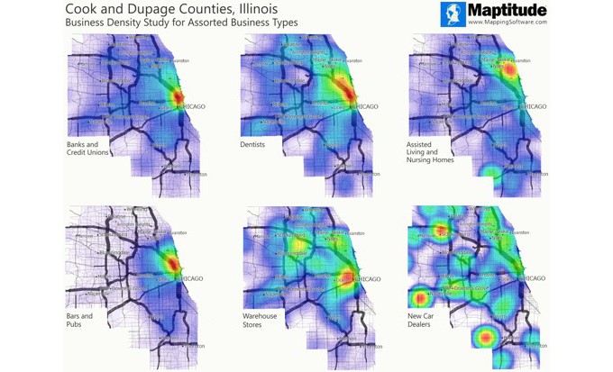
Business Density Comparison
September 2022:
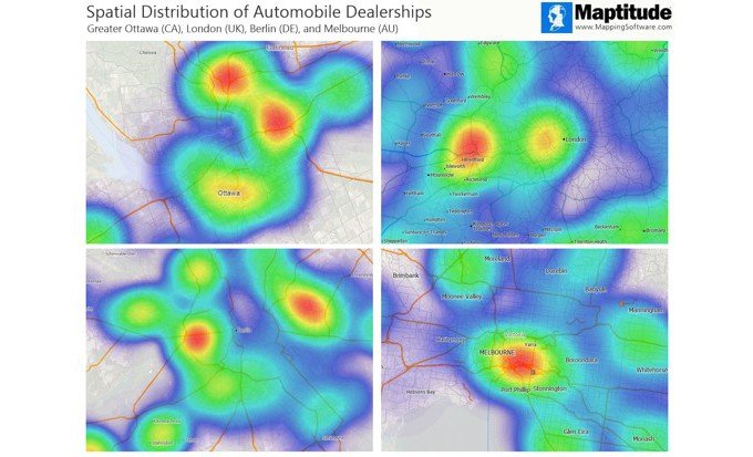
Auto Dealer Distribution in World Cities
August 2022:
U.S. and Canada Coffee Shops
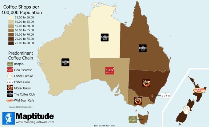
August 2022:
Australia and New Zealand Coffee
Shops
July 2022:
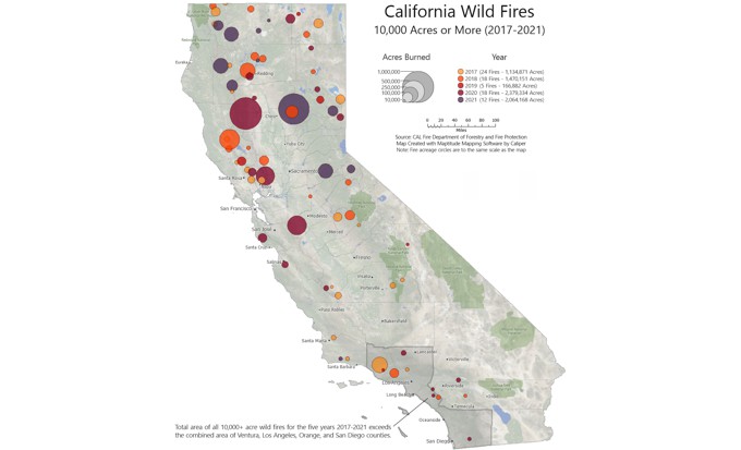
California Wild Fires 2017-2021
July 2022:
U.S. Business Locations 2022 Update
June 2022:
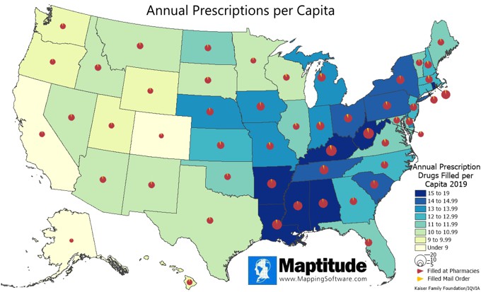
Prescription Drugs per Capita by State
June 2022:
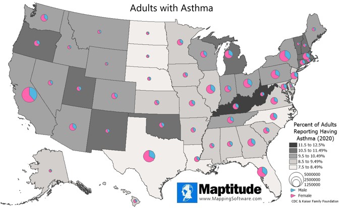
Adults with Asthma by State
June 2022:
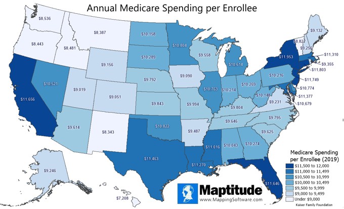
Medicare Spending by State
June 2022:
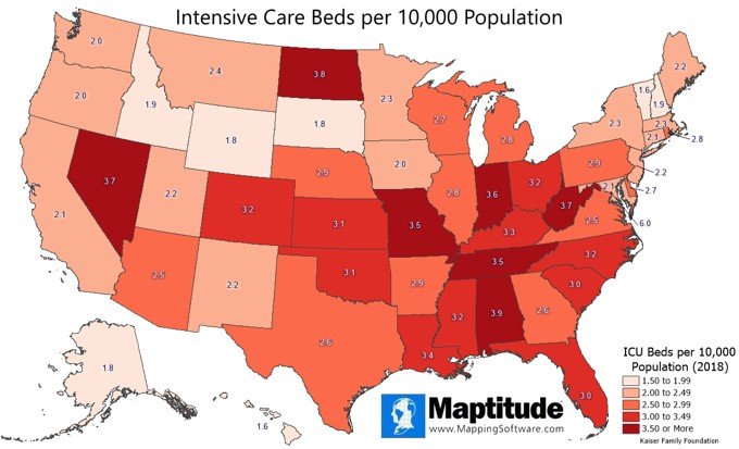
ICU Beds by State
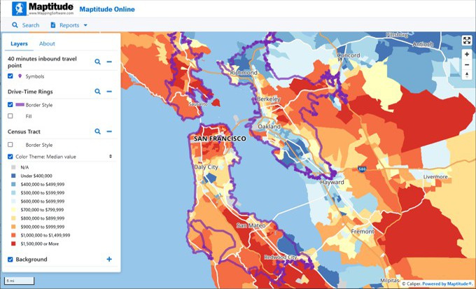
June 2022:
Maptitude Online Travel Time and Home Prices
May 2022:
Automatic Territory Optimization

January 2022:
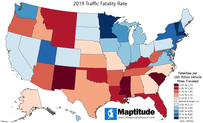
Traffic Fatality Rate by State
January 2022:
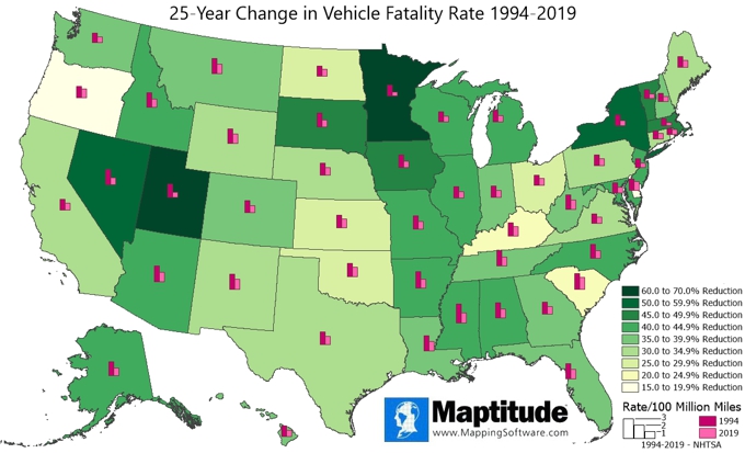
25-Year Change in Traffic Fatality Rates
September 2021:
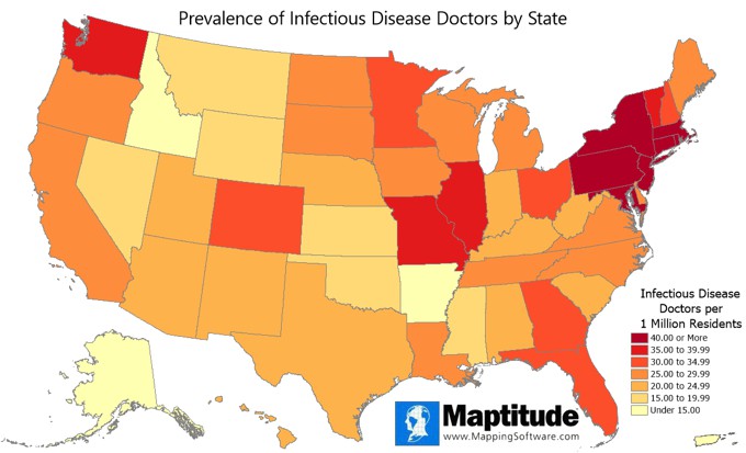
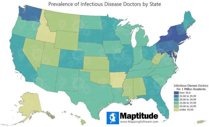
Infectious Disease Doctors by State
September 2021:
Closest NFL Stadium

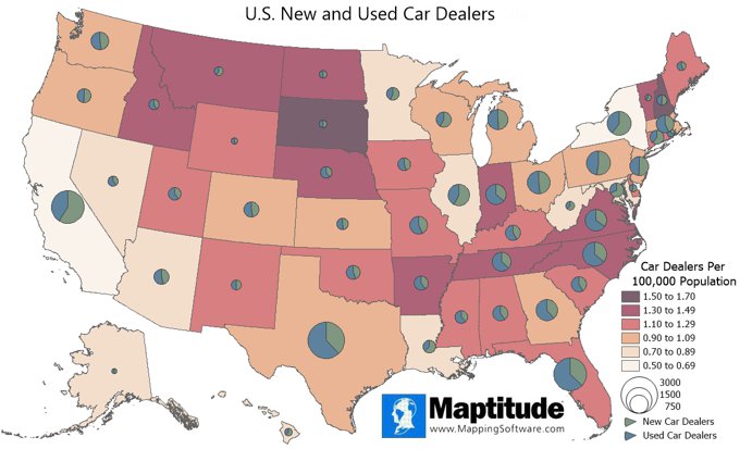
August 2021:
Car Dealers per 100,000 Population
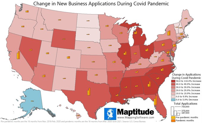
July 2021:
New Business Applications
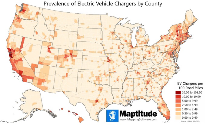
July 2021:
Prevalence of EV Chargers
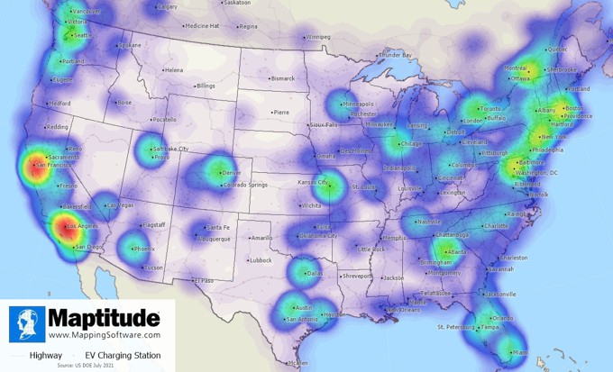
July 2021:
U.S. and Canada EV Charging Stations
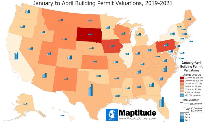
June 2021:
Building Permit Valuations (2019-2021)
May 2021:
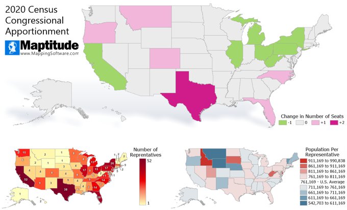
2020 Census Apportionment Changes
May 2021:
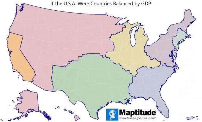
$3 Trillion U.S. Economies
May 2021:
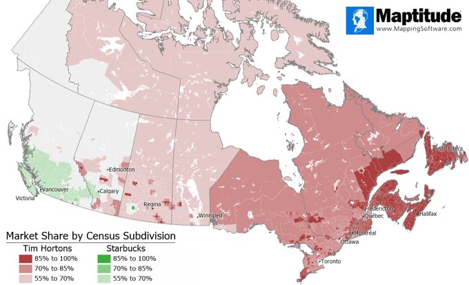
Tim Hortons vs. Starbucks Market Share
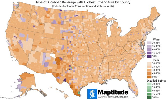
April 2021:
Wine, Beer, and Distilled Spirits Spending
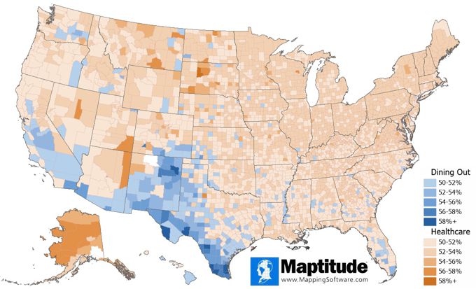
April 2021:
Healthcare and Dining Out Spending
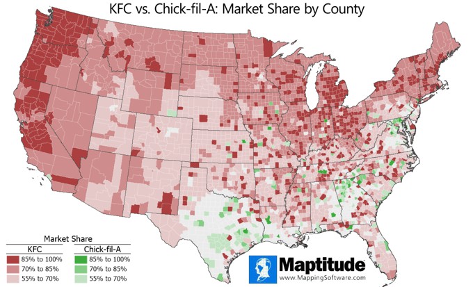
March 2021:
Brand Market Share of KFC vs. Chick-fil-A
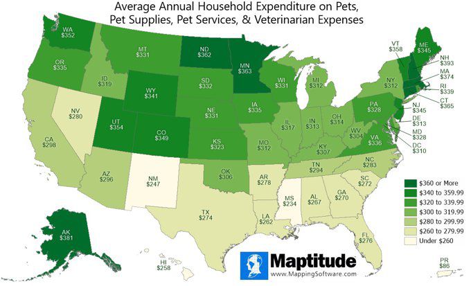
December 2020:
Household Pet Expenditure
December 2020:
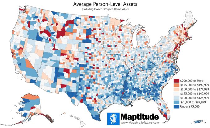
Per Capita Assets
December 2020:
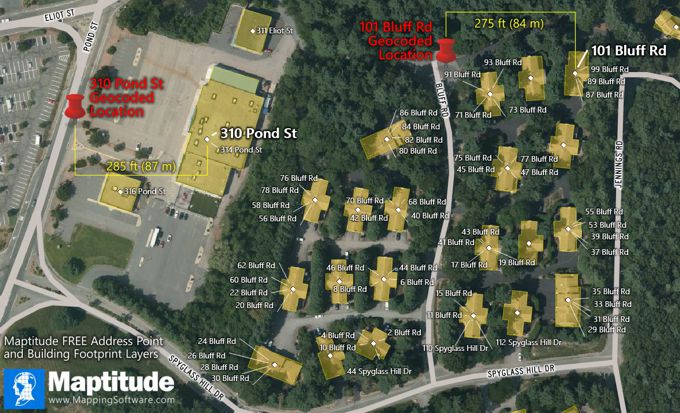
Address Point Rooftop Data
November 2020:
Example Maptitude Online App

September 2020:
Infectious Disease Doctors by State
July 2020:
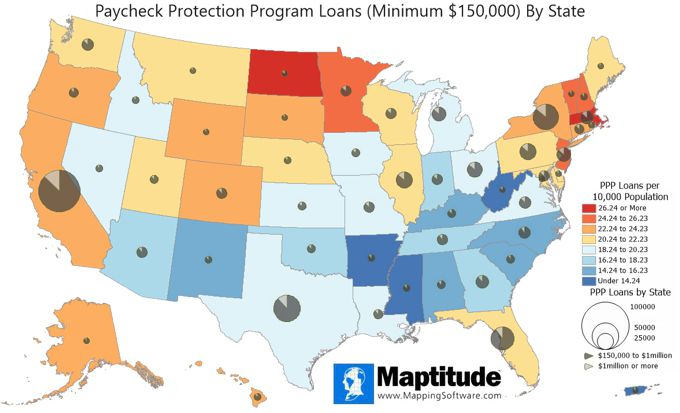
PPP (Covid-19) Loans by State
July 2020:
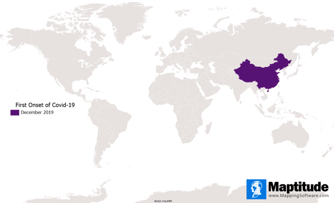
Spread of Covid-19
June 2020:
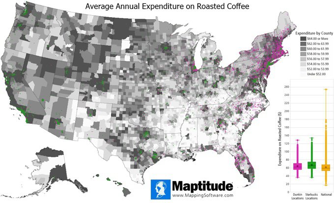
Coffee Expenditure Chain Comparison
June 2020:
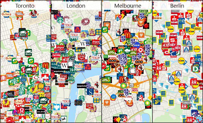
Australia, Canada, DACH, & UK
Businesses
May 2020:
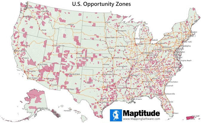
Qualified Opportunity Zones
May 2020:
Population Estimates
April 2020:
GDP from Food Services & Accommodations
March 2020:
Grocery Market Analysis
January 2020:
Trader Joe's vs Whole Foods Market Segmentation
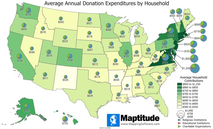
November 2019:
Donation Expenditures
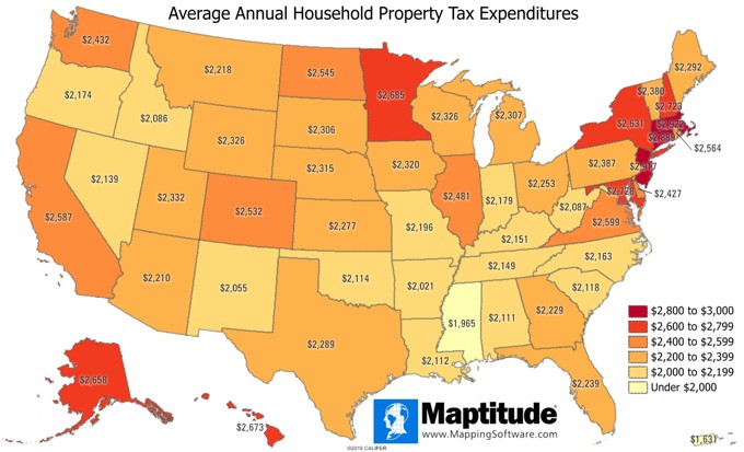
November 2019:
Property Tax Expenditures
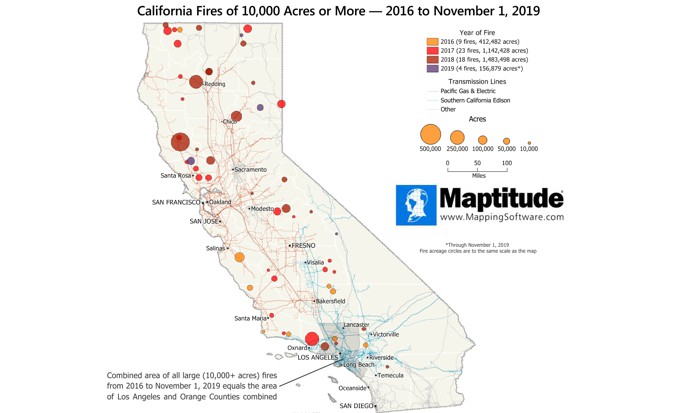
November 2019:
California Fires 2016-2019
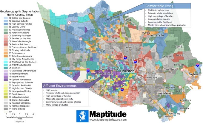
October 2019:
Geodemographic Segmentation
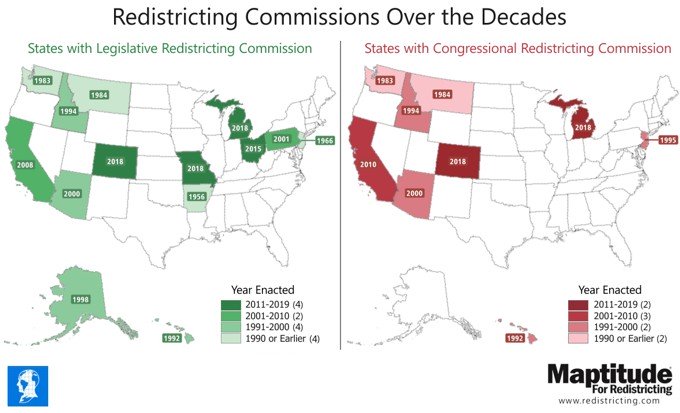
October 2019:
Redistricting Commissions
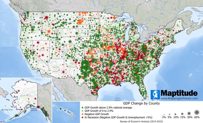
September 2019:
GDP Change by County
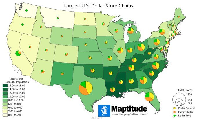
August 2019:
Largest U.S. Dollar Store Chains
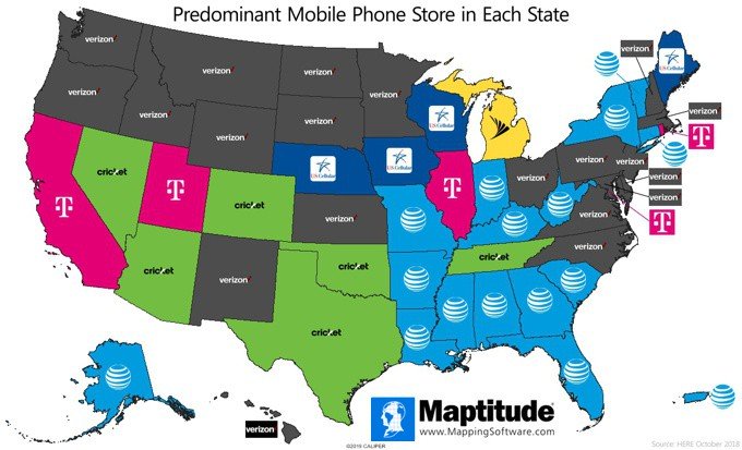
July 2019:
Predominant Mobile Retailer
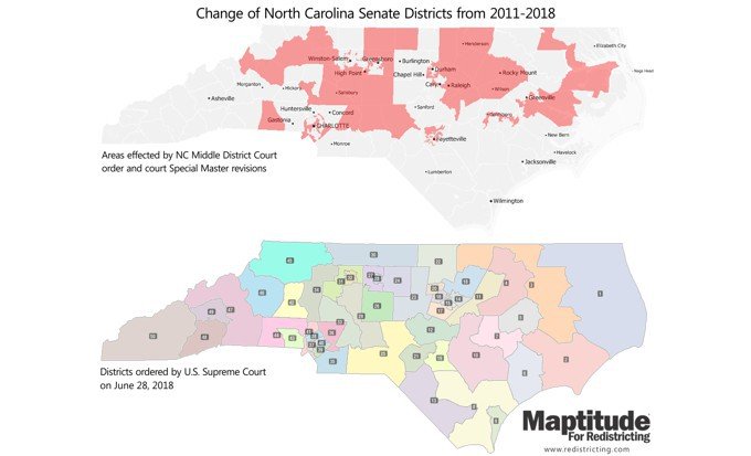
June 2019:
North Carolina Senate District Changes
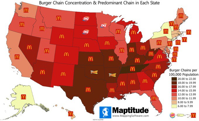
May 2019:
Burger Chain Restaurants
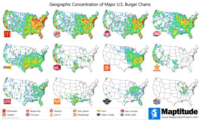
May 2019:
Concentration of Top U.S. Burger Chains
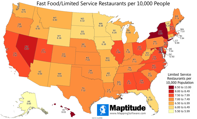
April 2019:
Fast Food/Limited Service Restaurants
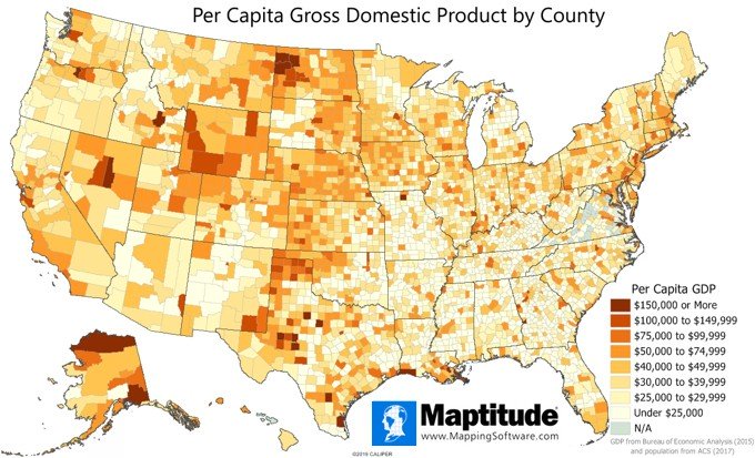
March 2019:
Per Capita GDP by County
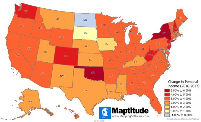
February 2019:
Change in Personal Income
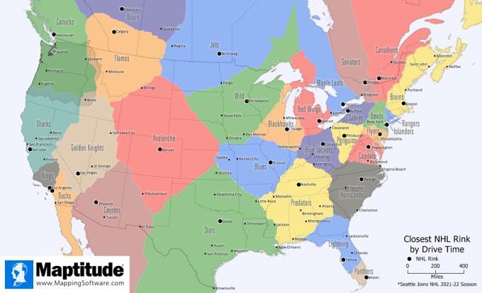
January 2019:
Closest NHL Rink
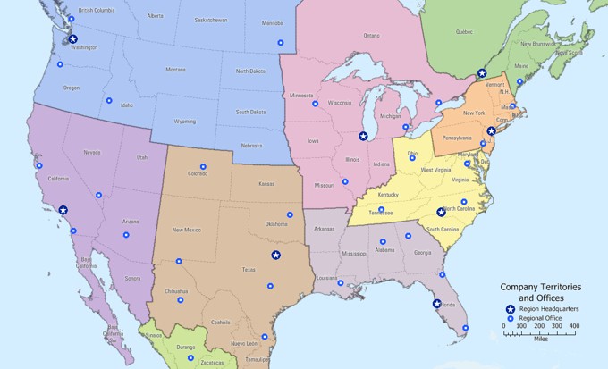
November 2018:
Custom Territory Maps
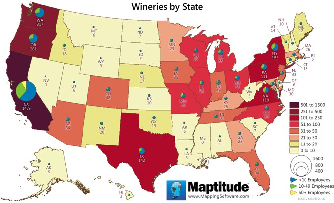
October 2018:
Wineries by State
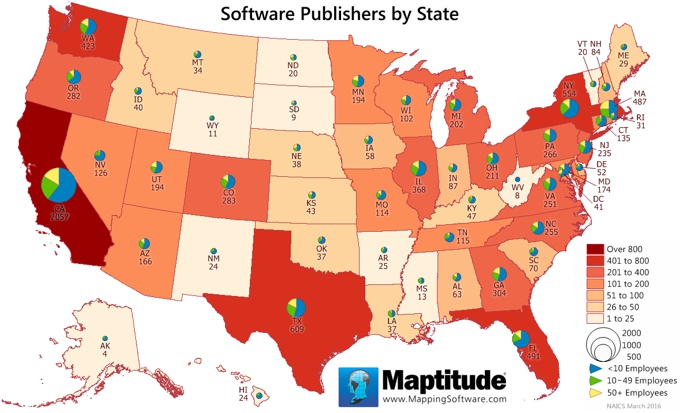
October 2018:
Software Publishers by State
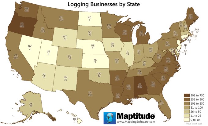
October 2018:
Logging Businesses by State
September 2018:
Maximum Traffic Count in Each State

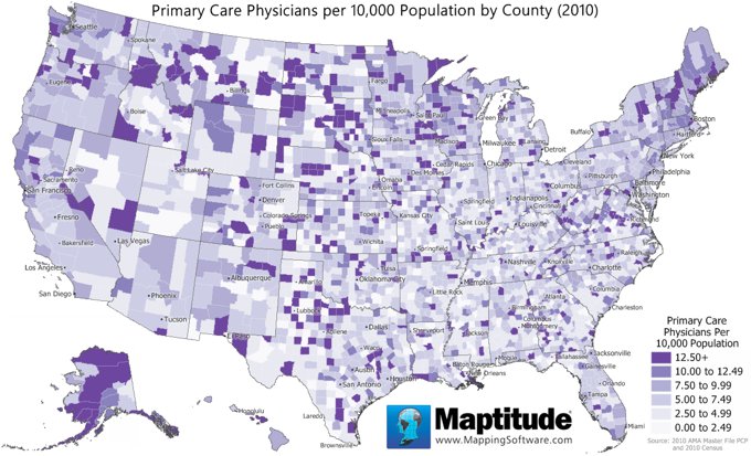
August 2018:
Primary Care Physicians
July 2018:
Concentration of U.S. Golf Courses

June 2018:
Most Common US Grocery Chains

May 2018:
Most Common UK Grocery Chains

May 2018:
Household Food Expenditures

April 2018:
Happy Tweets by State

March 2018:
Top and Bottom MSAs: Income Change

March 2018:
Change in Mean Income by MSA

February 2018:
Buying Power Per Household by State

February 2018:
Buying Power Per Household by County

February 2018:
Winter Olympic Medal Count (1924-2014)

January 2018:
1-Year Change in Income by State

December 2017:
Top 3 States for Income By Age Group

December 2017:
Win Percentage of FBS Schools by State

November 2017:
Traffic Volume

November 2017:
Closest NBA Team

October 2017:
Amazon HQ2 Bidders

September 2017:
Natural Gas Consumption & Production

August 2017:
Plastic Surgeons by State

August 2017:
Plastic Surgeons by County

June 2017:
Largest Pizza Chain by State

June 2017:
Pharmacy Dominance by County

June 2017:
August 2017 Eclipse

May 2017:
Average 401k Assets

April 2017:
Per Capita State Income Taxes

April 2017:
Per Capita State Tax Burden

April 2017:
Per Capita State Tax Collections

March 2017:
Healthcare Providers by State

February 2017:
Largest Coffee Chains by County

January 2017:
Area Code Boundaries

December 2016:
One-Day Snow Fall Extremes

December 2016:
Top High Schools

November 2016:
U.S. Cannabis Laws

November 2016:
2016 Election Issues

November 2016:
Turkeys Raised by State

October 2016:
Hospital Beds and Largest Hospitals

August 2016:
U.S. Drought Conditions

August 2016:
Massachusetts Property Tax Overrides

July 2016:
Walgreens Market Saturation

July 2016:
Large Flooding Events 2001-16

July 2016:
North America Flooding Events 2001-16

July 2016:
Europe Flooding Events 2001-16

June 2016:
Results of "Brexit" Vote by UK District

June 2016:
Weighted Centre of
Australia Addresses

May 2016:
Spread of Zika Virus: Time Series

May 2016:
New Zika Virus
Cases: 2015-2016

May 2016:
Zika Virus Cases in the United States

April 2016:
Wait Time for Surgery

March 2016:
Craft Breweries by State

March 2016:
Craft Beer Production by State

February 2016:
Coffee Shop Concentration by State
February 2016:
Bank Complaints by State

January 2016:
Largest Export by State

December 2015:
Projected 2020 Congressional Reapportionment

December 2015:
Per Capita
CO2 Emissions (Country)

November 2015:
Per Capita CO2 Emissions
(State)

November 2015:
Carbon Dioxide Emissions by State

November 2015:
Google Searches for "What do I need..."

October 2015:
Countries Barack Obama visited

October 2015:
U.S. aid received

October 2015:
Star Wars filming locations

September 2015:
Hazardous substances
& contaminants

September 2015:
Language spoken in Canada

September 2015:
Renewable sourced electricity generation

September 2015:
Primary sources for electricity generation

August 2015:
Most popular bank by state

August 2015:
Daytime population by ZIP Code

August 2015:
UK Jedi Knight population

June 2015:
Dentists per 10,000 population

May 2015:
Public sector employees by Congressional District

April 2015:
College dorms vs. correctional facilities

March 2015:
Microsoft MapPoint Megafile mapping

February 2015:
Population change 2010-2013

April 2015:
Entrepreneur top five franchises

January 2015:
Finance, insurance, and real estate employment

December 2014:
Home Depot and Lowe's locations

October 2014:
Petroleum pipelines

October 2014:
Pumpkin harvest by state

September 2014:
Auto dealerships

August 2014:
Biotech R&D

July 2014:
Cinemas per capita

June 2014:
Average medicare payment per office visit

May 2014:
Is your state young or old?

April 2014:
Mean household disposable income

March 2014:
Counties with lengthy commute times

February 2014:
Type of health insurance by state

February 2014:
Uninsured population by state

January 2014:
Florida student performance

December 2013:
Letters to Santa post offices

November 2013:
Vanderbilt hospital patient distribution

October 2013:
Chicago homicide hotspots

October 2013:
Homicides by race and income

October 2013:
Homicides by race
& 2-parent household

September 2013:
Toxic release inventory & seismic hazard

September 2013:
Major storms and population exposure

September 2013:
Predominant ancestry

August 2013:
J.C. Penney accessibility

June 2013:
Hurricane wind and pressure data

July 2013:
Diffusion of WalMart stores by decade

June 2013:
Florida hurricane tracks

February 2013:
Amtrak's busiest stations

May 2013:
Polling place allocation

March 2013:
European defense spending

January 2013:
Fukushima-type storm susceptibility

October 2012:
Cancer clusters

July 2012:
University enrollment patterns

June 2012:
Bankruptcies by postcode

January 2012:
Tennessee tornado damage

December 2011:
Arizona draft congressional districts

April 2011:
Fukushima evacuation zone

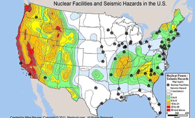
April 2011:
Seismic hazard & nuclear facilities
Home | Products | Contact | Secure Store
