Maptitude Help / Geographic Analysis Tools / Combining Attributes
Combining Attributes
When you create overlays, areas of influence, or territories, use geographic editing, or create one-to-many joined views, Maptitude often needs to combine the attributes of two or more map features. For example, when you join two areas together, Maptitude needs to add the population of the two areas to get the population of the new, combined area.
There are two things that can make this a bit tricky:
- Some actions involve only a part of some feature instead of the whole thing
- Some data fields should be added together, while others should be averaged together or handled in some other way
Partial Features
When you compute an overlay, Maptitude estimates the attributes for the working layer in one of several ways. If the reference layer is a point layer, Maptitude finds all the points in a working layer area and combines data for these points together in ways that are described below. If the reference layer is a line or area layer, Maptitude figures out what percentage of each feature is inside a working layer area, and applies that percentage to the attributes when combining the data together.
For example, suppose you wanted to compute the population of a 5-mile band around a potential restaurant location, based on 5-digit ZIP Code boundaries. In the following example, the 5-digit ZIP Code layer contains the population of each ZIP Code. In computing the overlay, Maptitude automatically accounts for the fact that only a portion of some ZIP Codes is included in the overlay.
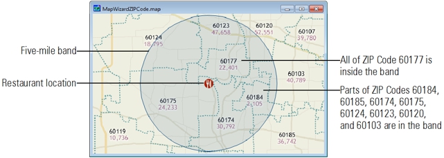
When you use the geographic editing tools (described in Geographic Analysis Tools ) to split line or area features, Maptitude uses similar methods to split the attribute data. For example, if you use the editing tools to split an area in half, Maptitude estimates the population of each new area to be one-half the population of the original area. If you split an area into two unequal parts, Maptitude divides up the population based on the size of each area.
Adding Versus Averaging
Suppose you knew the population and average income for five ZIP Codes in a town and wanted to compute the population and average income for the town as a whole. To get the town population, you’d need to add together the population of the five ZIP Codes. To get the average income for the town, however, you wouldn’t add together the average income of the ZIP Codes. Instead, you compute an average of the income for the five ZIP Codes. This average has to take into account not only the average income of each ZIP, but also the number of persons who live in each one. This is sometimes called a weighted average.
Aggregation Methods
The method used to combine attribute data is known as the aggregation method. All the data that come with Maptitude include information on the correct aggregation method. Whenever you perform overlays, use geographic editing, or create one-to-many joined views, Maptitude uses this aggregation method automatically.
When you create your own tables, you can choose a default aggregation method for each field. The default aggregation method is stored as part of the dictionary file. As a result, you can only specify default aggregation methods for tables stored in fixed-format text, fixed-format binary, and tab- or comma-delimited data files. You cannot define default aggregation methods for tables stored in dBASE format. Here is a summary of the aggregation methods and how they work:
| Method... | When features are joined/merged... | When features are split... |
|---|---|---|
| None (Blank) | Maptitude leaves the field blank | Maptitude leaves the field blank |
| Copy | Maptitude uses the value for one of the features (whichever one it encounters first) for the combined feature | Maptitude copies the value to all of the pieces |
| Add | Maptitude adds the values for the individual features, or the proportional values for parts of the individual features | Maptitude splits the value into parts, based on the length or area of the parts |
| Lowest | Maptitude uses the lowest individual feature’s value | Maptitude copies the value to all of the pieces |
| Highest | Maptitude uses the highest individual’s value | Maptitude copies the value to all of the pieces |
| Average | Maptitude computes a weighted average of the values from the individual features | Maptitude copies the value to all of the pieces |
| Std Deviation | Maptitude computes the standard deviation of the values from the individual features | Maptitude copies the value to all of the pieces |
Whenever you create overlays, areas of influence, or territories, use geographic editing, or create one-to-many joined views, Maptitude will use the default aggregation method for every data field. You also have the option to change the aggregation method for any field or fields. For some operations you can choose more than one aggregation method. However, you can use only a single aggregation method when using the geographic editing functions.
 To Change the Default Aggregation Method
- Choose Dataview>Table>Modify to display the Modify Table dialog box.
- Click Aggregation to display the Aggregation Method Dialog Box.
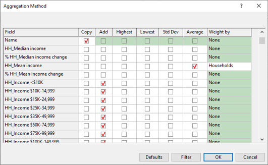
- The grid shows the aggregation methods for all of the fields. If you want, you can click Filter to choose a subset of fields.
- Change the default aggregation method as follows:
| To do this... | Do this... |
|---|---|
| Change the default aggregation method for a field | Check the desired aggregation options in each respective column. A checked box indicates a method that will be calculated. |
| Apply an aggregation method to all fields | Click the column heading to check or uncheck all rows for that column. |
| Restore default aggregation methods for all fields | Click Defaults. |
- Click OK to save these settings as part of the table.
From now on, the methods you chose will be used any time attribute data for several features are combined.
To change the aggregation method when calculating demographics
- Open the Aggregation Method Dialog Box from the Overlay dialog box or from the Demographic Settings dialog box for buffers, areas of influence, drive-time rings, or network zones.
- The grid shows the aggregation methods for all of the fields. If you want, you can click Filter to choose a subset of fields.
- Change the aggregation method as follows:
| To do this... | Do this... |
|---|---|
| Change the default aggregation method for a field | Check the desired aggregation options in each respective column. A checked box indicates a method that will be calculated. |
| Apply an aggregation method to all fields | Click the column heading to check or uncheck all rows for that column. |
| Restore default aggregation methods for all fields | Click Defaults. |
- Click OK. Maptitude returns to the appropriate dialog box. Continue as described in the respective how-tos.
After the overlay is created, the aggregation methods will return to their defaults.
To Change the Aggregation Method when Editing Map Features
- Click
 in the Layer Editing Toolbar to display the Configure Geographic Editing dialog box.
 - Click Update to display the Aggregation Method Dialog Box.
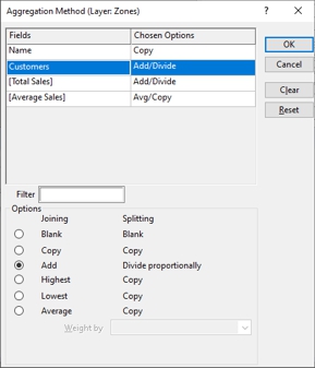
- Change the joining and splitting methods as follows:
| To do this... | Do this... |
|---|---|
| Change the methods for a field | Click on the field in the Fields list and click the desired options; Click Reset to undo your changes |
| Turn off all methods for all fields | Click Clear |
- Click OK.
The settings you chose will be used when you split or join map features.
To Change the Aggregation Method when Creating a One-to-Many Join
- Click the Options tab in the Join dialog box and choose the One To Many Join type.
- Click Aggregation to display the Aggregated Method dialog box.
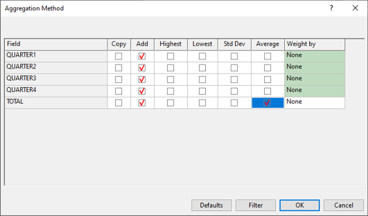
- The grid shows the aggregation methods for all of the fields. If you want, you can click Filter to choose a subset of fields.
- Change the aggregation method as follows:
| To do this... | Do this... |
|---|---|
| Change the default aggregation method for a field | Check the desired aggregation options in each respective column. A checked box indicates a method that will be calculated. |
| Apply an aggregation method to all fields | Click the column heading to check or uncheck all rows for that column. |
| Restore default aggregation methods for all fields | Click Defaults. |
- Click OK to return to the Join dialog box and continue creating the join as described in To Specify the Type of Joined View.
Attributes for the join will use the aggregation methods you chose.
©2026 Caliper Corporation