| Fall 2021 Newsletter |

|

|
| Website | Contact Us |Reviews | |
| A Warm Welcome to Our Users |
|
Welcome to Caliper’s 2021 Redistricting
Newsletter. We hope you and your loved ones are
well. As most of you are aware, the delay in the release of the Census 2020 P.L. 94-171 data has resulted in a protracted redistricting process. In August, Maptitude for Redistricting users were the first in the country to receive these data, within just a few days of the official release by the Census Bureau. For more details regarding the data release, see our Census 2020 P.L. 94-171 Redistricting Data press release. Perhaps the extra time has allowed you to be more thoughtful about the redistricting process and the unique needs of your community. We at Caliper have used the time to create a People’s Guide to Redistricting that demystifies the redistricting process for the public. We hope it will also serve as a valuable resource for those performing redistricting in an official capacity. We have also made our products even easier to use and more robust. Moreover, we have created a Plan Publisher Add-on that enables you to share your MORe or or Maptitude for Redistricting plans with anyone who has web access. |
| Redistricting for All: People’s Guide to Redistricting |
 In
the previous redistricting cycle, map drawing
technology was available to, and understood by,
only consultants and party experts. In 2021,
sophisticated map drawing capabilities are
available to a broader public. Caliper has just
released a
People’s Guide to Redistricting that
clarifies the redistricting process by providing
useful background information and explaining the
laws and principles necessary to create fair and
acceptable districting solutions. Maptitude for
Online Redistricting customers can foster public
engagement by directing constituents to this
comprehensive guide that explains the importance
of public involvement in redistricting, the
underlying data available, as well as best
practices for creating and evaluating plans. Users
of the Maptitude desktop software will find that
the guide is a helpful reference for information
about topics such as communities of interest,
measures of compactness and contiguity, and
gerrymandering. . In
the previous redistricting cycle, map drawing
technology was available to, and understood by,
only consultants and party experts. In 2021,
sophisticated map drawing capabilities are
available to a broader public. Caliper has just
released a
People’s Guide to Redistricting that
clarifies the redistricting process by providing
useful background information and explaining the
laws and principles necessary to create fair and
acceptable districting solutions. Maptitude for
Online Redistricting customers can foster public
engagement by directing constituents to this
comprehensive guide that explains the importance
of public involvement in redistricting, the
underlying data available, as well as best
practices for creating and evaluating plans. Users
of the Maptitude desktop software will find that
the guide is a helpful reference for information
about topics such as communities of interest,
measures of compactness and contiguity, and
gerrymandering. . |
| Spotlight on Minority Coalition Districts |
|
The following is an excerpt from our
People’s Guide to Redistricting on minority coalition
districts. Minority coalition districts
are a mechanism for improving minority
representation. Minority coalitions districts are
those that combine multiple minority groups to
create a majority-minority district. Although
different minority groups sometimes share views on
various political issues, this is not always the
case. In areas where one minority is well
established, that group can be resistant to
supporting new immigrant groups. Blacks and
Latinos do sometimes vote similarly but their
votes may depend on specific issues. Moreover,
research has shown that Latinos have joined with
blacks to vote for a black candidate, but the
reverse occurs less frequently. In fact, whites
sometimes ally with blacks to oppose Latino
candidates. Endorsements by influential leaders
are often significant. |
|
Maptitude for Redistricting: Easier to Use and More Powerful than Ever |
|
This year, in addition to including the most
up-to-date geographic and demographic information
available, we have focused on making Maptitude for
Redistricting even easier to use and more robust.
Specifically, we have continued to improve the
usability of our Plan Manager and plan editing
tools. We have also enhanced our analytical tools
and reports. Our Plan Manager now automatically adds plan libraries when new data are installed, shows the file path of the current library in the Plans tab, allows you to see the date and time that a plan was created as well as last modified, removes duplicate library entries, and allows you to navigate seamlessly using the Move Up and Move Down, and Move File buttons. 
We have made plan editing even easier by automatically updating the selection layer drop-down in the Redistricting Toolbox to include area layers added to the plan. In addition, we have added District Name and % Deviation as default labels for each district and highlighted Target and Source districts on the map, included measures of compactness for each district in the Districts dataview, and broadened the Select by Rectangle tool to select features by drawing a rectangle. 
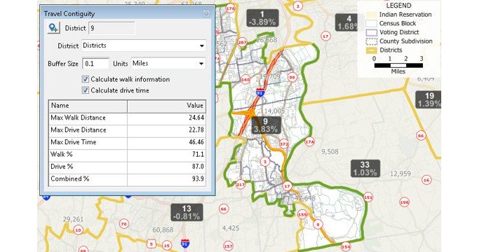
We have enhanced our interactive Travel Contiguity tool, which determines the percentage of intersections in each district that can be reached by walking, driving, or in combination, without leaving a district. 
The Disaggregation/Aggregation wizard now allows you to filter the 2020 census geography. 
We have also enhanced your ability to create and analyze Majority-Minority districts by adding reports and a check to ensure those districts comply with minimum target values. 
Other improvements include extended capabilities of the Communities of Interest tool to use user-supplied layers of communities and to allow GEOJSON files to be used as a community layer, the ability to print a map book to a series of PDFs or a single continuous PDF document, the enhancement of automatic district layouts to include District Long Names, and the ability to automatically label district boundaries with street names. See our website for more about new features in Maptitude for Redistricting 2020. |
| MORe Improvements |
|
Several improvements have been made to Caliper’s
online redistricting product (MORe) to make it
more streamlined and intuitive to your
constituents, and it has been receiving rave
reviews: Dean Salmons, Orange County GIS Coordinator, says “We are excited about this product. It’s…fairly cutting-edge…, and I think what’s so unique about this is that it really does meet the county’s needs; it really increases access and transparency in this process, and we’re super excited to be a part of it.” (https://www.youtube.com/watch?v=Eb9rsDpxn2E) Four collapsible toolboxes provide an uncluttered view of your plan. And a simplified ribbon at the top of the screen allows you to easily analyze plans in a variety of ways as well as print and share your plans.  As a site administrator, you are able to add themes to the map that users can select from a convenient drop-down menu.  Site administrators can customize plan submission rules, such as contiguity and keeping incumbents within their district, to comply with local districting requirements. Plans created by the public that do not meet the minimum requirements cannot be submitted for consideration. In addition to the ability to submit your plan to administrators, you can also share your plan with all other users or email your plan to a selected subset of individuals who have access to MORe. |
| Publish Redistricting Plans Online |
|
Have you ever wanted to share your Maptitude for
Redistricting plan with people who don’t have a
Maptitude account? Now you can! The Plan Publisher Add-on creates websites that allow anyone with web access to view enacted or submitted plans, to provide comments on the plans, and to download plan GeoJSON files. A demo site shows how easy it is to work with published redistricting plans.  How does the Plan Publisher Add-on work? The Plan Publisher Add-on is a great way to share on the web any number of plans with the public via a streamlined and easy-to-use interface and can be used with MORe or Maptitude for Redistricting. To publish one or more plans the user simply chooses the plan library and the webpage URL. Multiple plans can be published each with their own title and description and in separate web locations if desired. MORe customers already have a web server with plan libraries (e.g., the initial plan library or submitted plan libraries) enabling rapid deployment. The Plan Publisher Add-on converts your chosen library into JSON files for each district layer for the geographic area being published. Your styles are retained, and if a thematic visualization does not exist, default area styles are applied for an attractive map out-of-the-box. You can also add multiple PDF reports to each published plan:
The requirements for the Add-on are:
|
|
Learning:
Training:
December 7-9, 2021 • Virtual Classroom • Details | Register |
| www.Redistricting.com | ©2020 Caliper Corp. All Rights Reserved. |
|
|