Maptitude can meet the needs of candidates running for office at all levels of government. It provides you with easy-to-use mapping software and the latest and most detailed Census data for your constituency. With Maptitude, you can fine-tune your campaign strategy and efficiently deploy resources and volunteers.
Maptitude, with the free U.S. Country Package, includes the up-to-date demographic data from the Census and American Community Survey down to the Census Tract level*. The demographic data contains scores of attributes detailing population, age, race, gender, income, and housing that you can use to create informative maps that reveal important demographic patterns within your constituency.
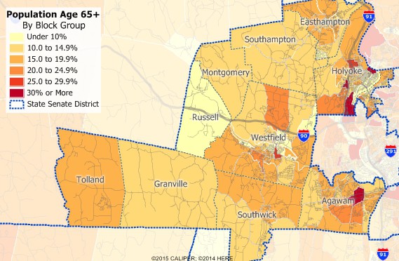
Maptitude is the best political campaign software and will help you understand your constiuency by identifying areas with concentrations of families with children, senior citizens, veterans, etc.
Obtain the latest voter file from your political party or county election office and use the sophisticated geocoding tools in Maptitude to add the voters to your map. You can then target the set of voters you want based on their party, voting history, or any other attribute in the voter file. You can also target voters based on where they live and what you know about the underlying Census demographics.
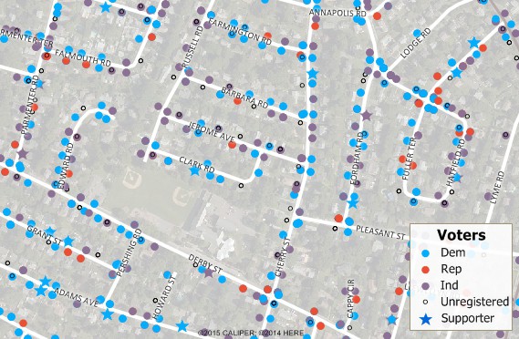
By using political campaigning mapping software you can target neighborhoods and voters you want to contact with mailings and neighborhood walks.
Add scheduled events to your map, and analyze coverage and timing. Add your supporters to the map so that you can identify the voters and supporters near each event and create contact lists. Schedule new events based on where your supporters are clustered.
Create a geographic layer of yard signs to verify that you have good area coverage. Identify and contact supporters who live in neighborhoods requiring additional yard signs or who live along busy streets.
Design efficient neighborhood walks that minimize walk time and maximize exposure to prospective voters. For each walk, print a map showing the route and voters to be visited and print detailed walking directions.
Locate voters requiring a ride to their polling place on the map. Assign volunteers to pick them up at their house and drive them to their polling place using a clearly annotated map and voter list. Minimize travel time spent by staff delivering political supplies and refreshments to polling places.
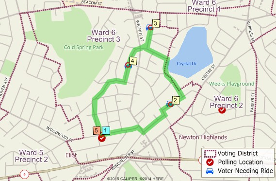
Plan routes for transporting voters and supplies to the polls.
*Additional data are available separately for Census Blocks and Block Groups. Legislative and Congressional District boundaries are also available separately.
Home | Products | Contact | Secure Store
