|
June 2017 Newsletter |
|||
|
|||


Website | Contact Us | Pricing | Live Demo | Free Trial | Reviews
International:
 New 2017 Country Packages for the UK & Ireland, Canada, Mexico, Brazil, and New Zealand
Seven 2017 Country Packages have now been released. Details for each can be found on the Maptitude 2017 New Features page. The United Kingdom and Ireland, Canada, Brazil, Mexico, and New Zealand Country Packages are now available, as well as the 2017 USA Country Package.
Key Features for Brazil, Mexico, UK & Ireland, Canada, New Zealand:
» Improved address matching/geocoding
» Updated street/road, business location, natural feature, building, landmark, city/town, and railway layers
» Updated travel times using real traffic patterns
» A new distance and drive-time tool creates an Excel table that lists the costs of travel between any number of origins and destinations
Additional Features:
» UK & Ireland: 2015 population estimates by age and gender for the UK; New layers for Ireland with demographics; Daytime and workplace population added for the UK
» Canada: Greatly improved geocoding; new layers such as phone Area Code Boundaries; 2016 population, population change, and dwelling data added
» New Zealand: New layer with almost 2 million accurate address point locations; Updated 2017 Meshblock Layer
![]()
![]()
Featured Map:
The 2017 Solar Eclipse
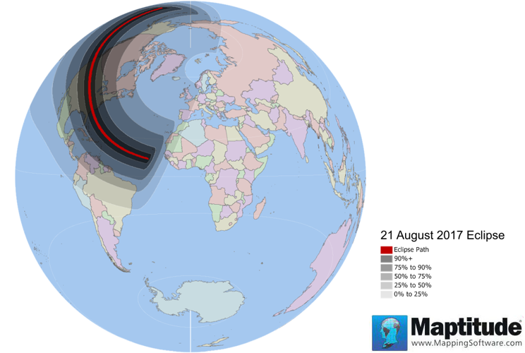
This month we used shapefiles from NASA to map the August 21, 2017 total solar eclipse using Maptitude 2017. The projection (choose File > Properties > Change Projection > The World > Lambert Azimuthal Equal Area) used allows us to see the percentage that the sun will be obscured globally.
Tech Tip:
How do I use the new & improved global geocoding tools in Maptitude 2017?
The June release of Maptitude includes new and improved global geocoding tools.
Please contact us if you require this functionality and are not seeing it in your version of Maptitude 2017.
This Tech Tip uses Maptitude 2017 and shows you how to:
• Use the new Locate by World City Tool
• Use the improved Find tool for zooming to global locations
Tricks & Tips:
Using Maptitude 2017 without a Country Package?
The June release of Maptitude supports a World Package when no Country Packages are installed.
When no Country Packages are installed, you can now use the Create a Map Wizard to open General Purpose maps, and to choose Map My Own Data to geocode your locations by country, by world city/town, and by coordinate. You can also use the Create a Map Wizard to show world country boundaries with your data attached.
Please contact us if you require this functionality and are not seeing it in your version of Maptitude 2017.
Please also note that there is a Download Free Layers Add-In that allows you to create Country Packages for anywhere in the world using open source data, and supports geocoding of varying accuracy all over the world.
Learning Maptitude:
UK Training Dates & 2017 Videos for UK and Canada!
 |
Upcoming Training: |
|
 |
New Maptitude 2017 Videos |
|
» Using Maptitude with the Canada Country Package (YouTube) » Using Maptitude with the United Kingdom Country Package (YouTube) |
 |
New 2017 Webinars! |
![]()
![]()
| News | ||
|
International Mapping:
| www.caliper.com |
Copyright ©2017, Caliper Corporation. All Rights Reserved. |