Mapping Software and GIS Glossary
A line sengment in a layer contains two end points and any number of additional shape points that help define its path between the end points. Similarly, the boundaries of area features in a layer have two end points and any number of additional shape points. Changing the shape of a line or area layer in a GIS involves adding, moving, or deleting shape points.
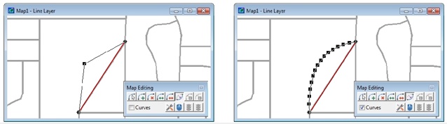
By adding shape points to the highlighted line segment you can create angles and curves
Maptitude Mapping Software gives you all of the tools, maps, and data you need to analyze and understand how geography affects you and your business. In addition to supporting many geographic mapping formats, Maptitude allows you to manually create and modify point, line, and area layers.
Learn More Free Trial Free for Students/Teachers
Home | Products | Contact | Secure Store
