Mapping Software and GIS Glossary
A spatial query is a request for specific information from a GIS database based on defined geographic criteria. It allows users to extract relevant data for analysis and decision-making.
Whereas it can be easy to perform an attribute query in a spreadsheet program (e.g., which customers bought the most goods, which parcels have values less than $500,000), specialized mapping software makes it easy to combine attribute queries with spatial quieries (e.g., which customers bought the most goods and are more than 15 minutes from a store, which parcels are less than $500,000 and are within 0.5 miles of an elementary school). By filtering features based on attribute and spatial queries it is possible to analyze features and spot trends not possible in a spreadsheet alone.
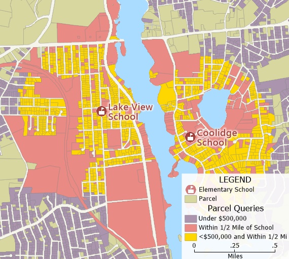
A spatial query of parcels within 1/2 mile of a school combined with an attribute query of parcels valued at less than $500,000
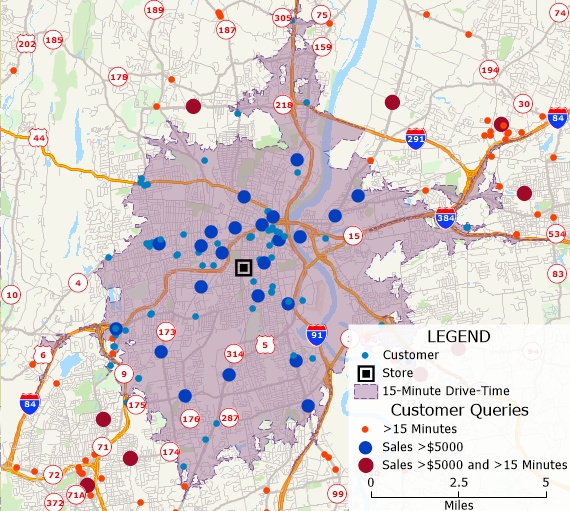
A spatial query of customers more than 15 minutes from a store combined with an attribute query of customers with sales greater than $5,000
Spatial queries are valuable for extracting information from large datasets efficiently and can be simple or complex, depending on the desired output. Examples of spatial query operators include:
| Operator | Use it to... |
|---|---|
| touching or contained | Query features that are contained within or touch features in the reference layer |
| inside | Query features that are inside features in the reference layer |
| not inside | Query features that are not inside features in the reference layer |
| within | Query features within a specified distance of features in the reference layer |
| not within | Query features that are not within the specified distance of the features in the reference layer |
| closest and within | Query, for each feature in the reference layer, the closest feature, as long as it is within a specified distance of the features in the reference layer |
| connected | Query line features that begin or end at the endpoints selected in the reference layer, or select endpoint features that are at the ends of the lines selected in the reference layer |
| select whether or not areas overlap | Query features that are inside any features in a reference layer of non-topological areas |
| Select only in areas that do not overlap | Query features that are inside a single feature in a reference layer of non-topological areas |
| Select only in overlapping areas | Query features that are in two or more features in a reference layer of non-topological areas |
Maptitude mapping software gives you all of the tools, maps, and data you need to analyze and understand how geography affects you and your business. Maptitude spatial queries let you select features in one layer (the working layer) based on how close they are to, or how far they are from, features in another layer (the reference layer). Examples of spatial queries include:
| If you want to... | Select from the reference layer... | And then query... |
|---|---|---|
| Find airports are near an Interstate highway | The particular interstate highway(s) of interest | Airports within 5 miles of the selected highways |
| Find customers in a sales territory | The sales territory of interest | Customers inside the selected territory |
| Find stores far from a distribution outlet | Any or all distribution outlets of interest | Stores not within 50 miles of the selected outlets |
| FInd homes near schools | Select any schools of interest | Homes within 0.5 miles of the selected schools |
| Find customers not within a 20-minute drive of a store | All drive-time rings that are less than 20 minutes | Customer not inside the selected drive-time rings |
Home | Products | Contact | Secure Store
