|
Featured Maptitude Maps:
Vanderbilt Hospital Patient Distribution
This month we showcase a map of the distribution of
Vanderbilt Hospital patients by ZIP Code. "Knowing where
your customers come from is essential to operating a
business. This map shows that Vanderbilt University Hospital
draws patients from all over Tennessee and eastern Kentucky,
plus a smattering from northern Mississippi and Alabama. The
average distance traveled to a business can be calculated if
you know how many persons come from each ZIP Code."
(Hendrickson Consulting)
The data are sourced from the Medicare Hospital Service Area
File, a valuable US government dataset. When used with
Maptitude, maps can be created showing the number of
discharges, length of stay, and total charges by provider
number and ZIP code of the Medicare beneficiary.
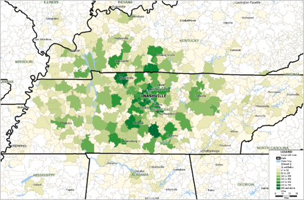
Map created by Hendrickson Consulting, used with permission
More Featured Maps...
If you would like to see your maps showcased here, or are
interested in custom map making services and software please
contact
Caliper.
Focus on Maptitude:
Caliper
Brings Site Location Analysis to Real Estate with the Free
Maptitude MassStats Application
Caliper wants to turn real estate agents, site planners, and
home buyers into cartographers with a new mapping tool
designed to visualize demographic data.
In November, Caliper launched
Maptitude MassStats,
a
free web-based software tool designed to let
anyone explore data for Massachusetts such as education,
crime, environment, and election results. MassStats is a
valuable real estate tool that will help organizations have
a better understanding of location. Companies can look at
where they can relocate to be near public transportation,
while families can identify a safe neighborhood with good
schools.
The idea is to help people get more value out of the complex
and de-centralized big data already publicly available. If
that data can be plotted on a map, it will be easier for
organizations and the public to make decisions, Caliper
executives said at the company's offices in Newton, MA
(USA).
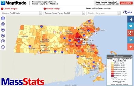
It's taking "the often overly complex and unusable
government data, and through mapping bringing a more
intuitive and powerful form of interaction," said Howard
Slavin, President of Caliper Corporation.
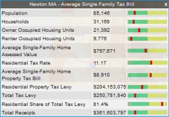
With MassStats,
anyone can choose to view data down to the town and street
level, see commuter rail stops, school district scores,
hospital locations, and even crime statistics. The data are
all presented with user-friendly maps. You simply choose
from a menu the information that you would like to see, and
a color-coded map of cities and towns is displayed. You can
use tools to zoom in and out on the map and can click on a
city or town to see specific data for that community in a
table.
|
Good thematic analysis can be complex, especially in
a web interface. This Maptitude powered application
does a nice job of making it simple for the user.
Steve Lombardi, Microsoft
|
|
 |
Maptitude makes it easy to create the maps you need.
Please contact our
Maptitude Sales Team with any questions.
Using Outdated Data &
Technology?
Upgrade to Maptitude 2013!
 Users
of Maptitude 2012 and Maptitude 6.0 can still get our US$395
reduced upgrade pricing. This deal saves you US$300!
Upgrade now to avoid being caught out by using last year's
features and data. Users
of Maptitude 2012 and Maptitude 6.0 can still get our US$395
reduced upgrade pricing. This deal saves you US$300!
Upgrade now to avoid being caught out by using last year's
features and data.
Also, each US order will include a free US
ZIP Code update: a US$250 value! The combination of the
offer and free data saves you US$550!
For pricing and ordering information please visit the
Mapping Software Store, e-mail
Maptitude Sales, or call U.S. Sales at +1 617-527-4700.
Limited Offer: Valid for Maptitude 6.0 or later.
Restrictions Apply.
You need the newest maps, the latest
demographics, and the fastest, most
intuitive
Maptitude!
  |
| |
|
Maptitude 2013 Training:
 Limited
Availability Limited
Availability
Advance registration for the instructor-led training courses
is required. Upcoming classes:
•
December 16-17: London (UK)
•
March 3-5: Boston MA
Space is limited, so
register online as soon as possible. If you have any
questions, please call Maptitude Training (USA) at +1
617-527-4700, or send an e-mail to
sales@caliper.com.
|
Maptitude International News:
Maptitude Demos in Sao
Paulo, Brazil
The Caliper Corporation booth (#1944) at the Transpo
Quip Latin America 2013 conference will feature
Maptitude Mapping Software. The event takes place in
Sao Paulo, Brazil, on December 3-5, 2013. The free
conference is the leading event for solutions for
the transportation infrastructure industry in Brazil
and Latin America.
Attendees are invited to view the powerful
capabilities of
Maptitude for Brazil which is tailored
specifically to the Brazilian market and can be used
in conjunction with the
beta Portuguese menu tool.
There are also
Maptitude Country Packages available for many other
Latin American countries.
|
|
Did You Know?
Retail Data in Maptitude
 Maptitude
is a powerful tool for retail analysis. It includes
detailed demographics describing the locations of
businesses, households, residents, and employees,
which are critical for market research. In
combination with the latest demographics, the
drive-time ring and territory tools provide a clear
picture of sales and competition and can be overlaid
with data such as buying power/disposable
income. (See
sales & marketing maps here.) Maptitude
is a powerful tool for retail analysis. It includes
detailed demographics describing the locations of
businesses, households, residents, and employees,
which are critical for market research. In
combination with the latest demographics, the
drive-time ring and territory tools provide a clear
picture of sales and competition and can be overlaid
with data such as buying power/disposable
income. (See
sales & marketing maps here.)
For example,
Maptitude Country Packages include comprehensive
locations for shops, restaurants, grocery stores,
hotels, and more. These data provide a complete
framework for exploring retail scenarios.
|
Maptitude News and Press:
•
Rolling Stone: How Republicans Rig the Game
•
A Healthy Understanding, (featuring Maptitude maps)
•
KQED: Redistricting in Oakland: Down to Two Potential Maps
•
Oakland Local: Oakland redistricting talk: 45 proposed maps
now circulating
•
More Maptitude News...
Maptitude Solutions:
Banking GIS
Business Mapping
Census Data Mapping
Community Development
Election Management
Enterprise GIS
Franchise Mapping
GIS Software
GPS Mapping
Insurance Mapping
Law Enforcement GIS
Location Intelligence
Marketing & Sales Mapping Software
Public Health Mapping
Real Estate Mapping
Redistricting
Route Planning & Deliveries
Satellite & Aerial Imagery
Street Mapping
Territory Mapping
Web Mapping
World Mapping
|
|
Tech Tip:
Analyze Market
Area Demographics
Because most retail outlets target particular socio-economic
groups, it is useful to be able to visualize the reach of
stores in relation to target demographics. Maptitude
analysis tools can determine the area required to be able to
service a target population such as people in a particular
age and income group. By identifying these market areas,
retailers can better asses their store placement and
competition.
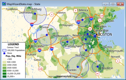 Maptitude
can create rings so that they contain a particular value
such as population, income, or area. The width of each ring
is computed by Maptitude on the fly. For a video tutorial
see:
Creating
Overlays and Buffers. Maptitude
can create rings so that they contain a particular value
such as population, income, or area. The width of each ring
is computed by Maptitude on the fly. For a video tutorial
see:
Creating
Overlays and Buffers.
Maptitude is widely used to conduct
site,
territory, and
marketing research. For example, new stores can be
considered in locations where there is a gap in the market,
and sales campaigns can be conducted to assess the market
potential. By cross-referencing data from multiple sources,
such as loyalty schemes and demographics, it is even
possible to prioritize certain opportunities to better
inform and real estate decisions.
The following steps illustrate how to create rings around
locations and to identify those areas reaching a particular
group:
-
Choose File-New, choose Map from
the New File dialog box, and click OK.
This brings you to the Create-a-Map Wizard.
-
Choose the Map of my own data option.
-
Browse for the Excel file containing your data. Choose
the sheet in the Excel workbook that contains your data
and has fields such as address and postal code. Click OK.
-
Follow the prompts for locating your data by address.
Maptitude creates a map of your data.
-
Choose the layer to use in creating the bands from the
drop-down list on the Standard toolbar.
-
Choose Tools-Geographic Analysis-Bands
or click on the Standard toolbar to display the Bands
dialog box.
-
Choose to create bands around All Features
from the Bands Around drop-down list.
-
Type a name for the new map layer in the Create
Layer edit box.
-
Check Build to Value, choose the source
layer and field from the drop-down lists. This is
usually the default overlay layer, and a field such as
Population.
-
Type in the target values you want, separated by spaces
or commas (e.g. 1000, 2000 people).
-
Check Separate Bands to have each
feature have its own separate bands. You can choose a
field to name the bands from the Band Names From
drop-down list.
-
Click OK. Maptitude displays the
Save As dialog box. Type a file name
for the new geographic file, and click Save.
-
Maptitude creates a new layer containing the bands and
adds the new layer to the map.
To insert your results into a presentation you can choose
File-Save As for each window to
export your map and figure for use outside of Maptitude.
|