| Mapping, GIS, & Transportation Software Solutions |
| Mapping, GIS, & Transportation Software Solutions |
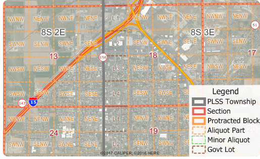
NEWTON, MASSACHUSETTS (USA) - Caliper is excited to announce the release of free PLSS and TXSS map layers. The Land Ordinance of 1785 established the Public Land Survey System, also known as the Township and Range system. Today the Bureau of Land Management maintains the Survey as a way to accurately categorize large areas of the Continental US. Area layers for the PLSS and for the Texas Survey System (TXSS) are now downloadable for free for Maptitude 2017 users.
The PLSS and TXSS are used:
The downloaded layers can be added to any Maptitude 2017 map. The PLSS divides large areas of the USA into townships and sections (First Divisions and Second Divisions). The Texas Land Survey Layer splits the state into tracts, sections, and labors.
Caliper Corporation develops state-of-the-art Geographic Information Systems (GIS) software. With a focus on usability, Maptitude is designed to be a cost-effective, professional healthcare mapping software product. Maptitude enables organizations to leverage their location-based data to improve decision making and planning, while minimizing expenditure through competitively priced solutions.
Caliper is a privately held corporation and is a leading developer of mapping, redistricting, transportation, and GIS software.
"Maptitude has been an important tool for showing the geography of a variety of facilities and parameters, from rig trends by state, to patent trends by metro area, to the location of important infrastructure installations. Being able to illustrate and map these elements with Maptitude was essential for the analysis and, in addition, the software is backed up with outstanding support if needed."
Charlotte Batson
Petroleum Engineer / Shale Oil & Gas Consultant
"Over the past several years I’ve spent dozens if not hundreds of hours trying to figure this out. But the Maptitude PLSS data is wonderful because it covers most of the US and not just Oklahoma and includes Texas which is unique and covers quarter sections and below. Miraculous. I’m not sure that you Yankees understand just how useful this data is to us folks in flyover country. But it’s great. Thanks."
Larry D. Lahman
Mitchell DeClerck | Oklahoma’s Oldest Law Firm
Founded 1893
Home | Products | Contact | Secure Store