
How do I use a Subset of Geography in a Redistricting Plan?
How to use a Subset of Geography in a Redistricting Plan
How Can I Display the Plan Components Report With Shortened Tract Or Block Numbers?
Using shortened block or tract numbers in the Plan Components Report is very easy. All you have to do is create a formula field (which you call Name) that contains the information you want displayed. For example, to show the block group and block number of a block (the last 6 digits of the 15-16 …
How Can I Display the Plan Components Report With Shortened Tract Or Block Numbers? Read More »
How Can I Create Labels That Span Multiple Lines? (Multi-line Labels)
Formulas can be used to make labels with multiple lines like in the following example: There are a few things to remember when creating multiple line labels: Any text strings should be contained in quotes. In the example above, the words “Tot. Pop.: ” are in quotes. All numeric values should be converted to text …
How Can I Create Labels That Span Multiple Lines? (Multi-line Labels) Read More »
How Do I Create a Formula Field and Add It to My Summary Fields?
To add custom formula fields to your plans, you can add your formula fields to the maps your plans are based on (typically Block-VTD-County.Map or Block-Block Group-Tract-County.Map). You can follow the steps below to add custom formula fields to a map. Open the map you want to add a formula field to by doing File>Open, selecting …
How Do I Create a Formula Field and Add It to My Summary Fields? Read More »
How are Prisoners Addressed in 2020 Redistricting Data?
How prisoners are counted
What are Group Quarters?
Explanation of 2020 Census group quarters definitions
How Do I Create a New Template Based on a Previous Template?
Creating a new template using a template createed with previous geography
How Do I Create a New Plan Based on Previous Geography?
Creating a new plan using previous geography
How can I create a list of features that have not been assigned in my plan?
It is useful to identify which unassigned features contain population so that you can easily review them in your plan. To do this, follow these steps: Choose Redistricting>Plan Utilities>Export Plan Choose All Districts from the District dropdown Check “Export as Layer Hierarchy Components” Click OK Enter a filename and click Save The resulting file contains …
How can I create a list of features that have not been assigned in my plan? Read More »
How do I customize the style for layers that are using Feature Display?
How to work with a layer that has Feature Display settings applied
Working with Data in Maptitude for Redistricting
Using the Info tool, displaying data in a dataview, and working with dataviews
How Do Create New Labels for Precincts in My Map?
Customizing data for labels
Using Field Sets
How to use field sets
How Do I Incorporate Block Level Data into Other Layers?
How to incorporate block level data into all layers
How Can I Determine the Total Miles of Roadway in a District?
How to display the mileage of streets in a district.
How Can I Use My Own Layer to Select Features While Redistricting?
Using custom geography for selecting features
How to Use Incumbent Information in a Plan
How to Use Incumbent Information in a Plan
How do I automatically map incumbents using the locate tools?
How do I add incumbents to the map
How Do I Incorporate ACS Data into My Plans?
How to incorporate ACS and CVAP data into plans.
How Do I Restrict My Redistricting to a Subset of a Geographic Area?
Restrict redistricting to a geographic area
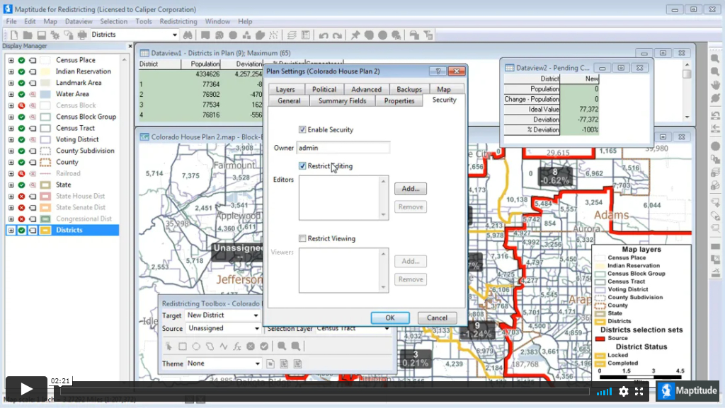
Plan Security
How to secure a Maptitude for Redistricting plan library and specify which users have editing and viewing rights to each plan
How do I use Communities of Interest?
You can identify a community of interest by creating a named selection set using the standard Maptitude selection tools.
How can I create a theme that shows the predominant race/ethnicity in each feature?
Create a theme that shows the predominant race/ethnicity in each feature.
How do I merge subplans?
You can merge sub plans for different geographic areas into an open plan.
How do I create a plan with current political districts?
If you already have an , you can import that file during the creation process to rebuild the plan in Maptitude for Redistricting. Choose Redistricting>Plan Manager to display the Plan Manager dialog box. Choose a library for the new plan from the Library drop-down list. Click New to display the New Plan wizard. Click the …
How do I create a plan with current political districts? Read More »