|
New Release:
Maptitude 2016 is
Available Now!
 Maptitude 2016 is a major release of
Caliper Corporation's popular GIS
(Geographic Information System) and
mapping software. The 2016 version
provides the most up-to-date and
accurate data available. Maptitude 2016 is a major release of
Caliper Corporation's popular GIS
(Geographic Information System) and
mapping software. The 2016 version
provides the most up-to-date and
accurate data available.
New territory management tools
Businesses require robust territory
creation tools that excel in both the
handling of data tables and in the
visual manipulation and representation
of service areas. Maptitude 2016 was
designed to exceed these requirements
and provides an intuitive Territory
Wizard and a sophisticated Territory
Manager with complete undo and redo
support.
“It is simply amazing to see Maptitude progress.
In Maptitude 2016 the Routing
Manager and Territory Manager
are extremely useful and user
friendly. The added functionality,
updated interface, and the speed of
calculations are exactly what I need
to perform my work as a logistics
consultant.”
Paul Lucassen
Lucassen
Consulting
Support for MapPoint-like tools &
queries
Maptitude now dominates the space
vacated by Microsoft MapPoint. Maptitude
ships with the latest maps, data, and
demographics. With enhanced versions of
the features that Microsoft MapPoint
users are familiar with, Maptitude
retains the ease-of-use of the MapPoint
tools while providing the functionality
that Microsoft users could only wish
for.
The new and improved tools include:
-
Territory management and import
-
Route/directions management
-
A hover label tool
-
A circle/radius drawing tool and a
line drawing tool, each auto-labeled
with distance
-
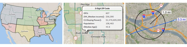
Support for metropolitan areas and
3-digit ZIP Code areas
-
MapPoint, Streets & Trips, and
AutoRoute file format support
Updated road networks and travel speeds
New U.S. data sets provide access to the
most up-to-date geographic information
available. Maptitude now includes
October 2015 map content that allows for
accurate address locating and street
visualization, as well as robust data on
which to calculate shortest paths,
drive-time rings, and drive-time
territories. Accurate,
comprehensive, average traffic speed
data are now included.
Faster distance and travel time
calculations
Speed improvements provide faster access
to maps, routes, drive-time rings, and
geographic analysis. Maptitude 2016
provides significant speedups in map
display with faster drawing of styles,
filters, layers, and labels.
Improved drive time areas
The Drive Time Rings Toolbox improves
your ability to create the most accurate
drive-distance travel analysis on the
market with the following enhancements
to the tool:
- Updated shortest path calculations
- Improved speed and efficiency while
using less memory
- Redesigned interface with cumulative
bands, separate origins, and driving
speed adjustments
The latest demographics
The US Census boundaries (e.g., Tracts,
Counties, MCDs, MSAs, States) and the 3-
and 5-digit ZIP code areas that come
with Maptitude contain some or all of
several demographic profiles from a
variety of data providers. These sources
include the 2010 Census and the 2014
ACS Census to name
a few. These data are available for the
USA, Puerto Rico, and the Territories.
The ZIP Code, Tract, County, and State
layers also include updated buying power
(disposable income) figures. Tracts also
list updated banking compliance FFIEC
data for 2015. The Map Librarian makes
it easy to access a series of
pre-defined thematic and shaded maps of
these data.
Please
contact the
Maptitude Sales Team
with any questions. View our new
Maptitude 2016 videos
here.
|

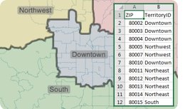 The
new territory
tools make it
easy to create
and manage your
territories.
Being able to
access and share
your territory
definitions,
such as
postal/ZIP Codes
by territory, is
a critical step
in the
definition of
your boundaries.
This was one of
the best
features of
Microsoft
MapPoint and is
new in Maptitude
2016!
The
new territory
tools make it
easy to create
and manage your
territories.
Being able to
access and share
your territory
definitions,
such as
postal/ZIP Codes
by territory, is
a critical step
in the
definition of
your boundaries.
This was one of
the best
features of
Microsoft
MapPoint and is
new in Maptitude
2016!