 By Stewart Berry
20 January 2026
MapPoint® is discontinued. If you're searching for the best MapPoint alternative, Maptitude is the leading solution. Maptitude Mapping Software now dominates the desktop space vacated by Microsoft MapPoint. Maptitude is a widely-used and full featured mapping application. The software is designed for business users in every global market. Maptitude is the best MapPoint replacement.
MapPoint provided outdated data. Don't use old data for new location-based decisions. Upgrade to Maptitude to use the latest features, Census numbers, and demographics.
Microsoft's discontinuance of MapPoint left a void in the mapping software landscape. Fortunately, Maptitude has emerged as the ideal replacement, offering a feature-rich experience that seamlessly integrates with your existing MapPoint data.
By offering a seamless transition from MapPoint and a wealth of powerful features, Maptitude is the definitive solution for businesses and organizations seeking a comprehensive mapping software.
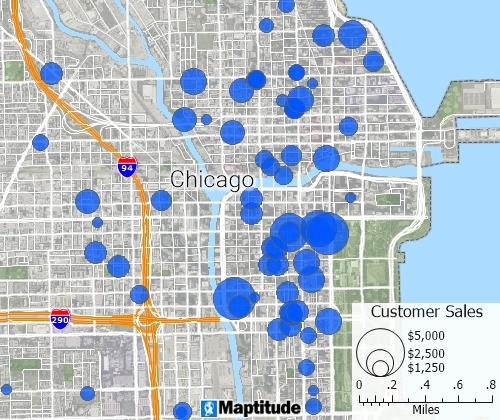
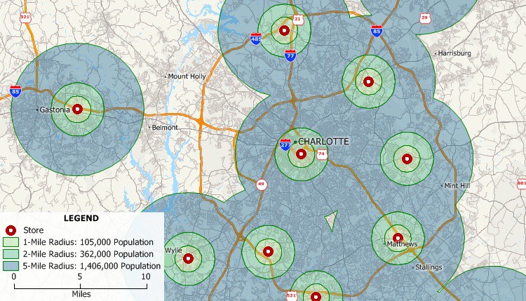
Create pin maps by address, postal code, coordinate, and more for unlimited numbers of records
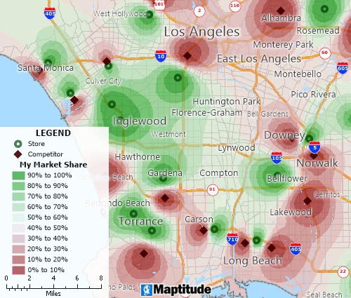
Determine trade areas and identify valuable sites
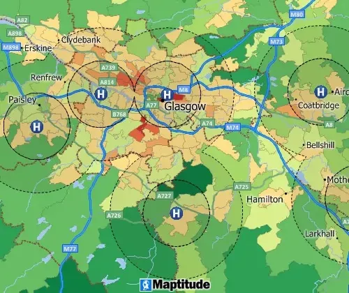
Circular buffers/bands for analyzing proximity
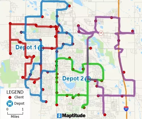
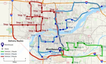
Optimize routes for deliveries and pickups in fixed time windows
coverpoint
IT solutions
Why Coverpoint chose Maptitude as the alternative to MapPoint
Read more...
In today's data-driven landscape, map-based analysis and visualization are invaluable tools for businesses of all sizes. However, traditional GIS software can be prohibitively expensive, often requiring recurring subscriptions or cloud storage fees. Fortunately, Maptitude emerges as a game-changer, offering unparalleled value and control.
Desktop or Online. One-time or Subscription. Maptitude provides mapping that meets your needs.
The unique value proposition provided by Maptitude makes it the ideal MapPoint alternative for businesses seeking a powerful, affordable, and secure mapping solution. By providing a one-time purchase option and on-premise data storage, Maptitude empowers businesses to unlock the power of mapping without compromising budgetary considerations or data security concerns.
The retirement of MapPoint left many businesses scrambling for a new mapping solution. Fortunately, Maptitude has emerged as the clear choice for former MapPoint users, offering a seamless transition and a wealth of additional features. Here's what some satisfied users have to say:

|
“I was in a bind when MS retired MapPoint. I discovered Maptitude in 2009 and have been using the software since then. Once you take time to use the various features, it becomes a joy to use when evaluating different market conditions/situations. I do enjoy using this software.”
|
 |
“Easy to use and speedy to map, comparable for ease of use to the discontinued MapPoint but offers lots of stronger features. The Video tutorials are a really good resource.”
|
 |
“Ease of moving territories, obtaining census data, and plotting territories to that data. Beautiful interface and several ways to customize the product and exports. The ability to pull in my older MapPoint files and data was a huge plus!”
|

|
“I believe that Caliper's Maptitude continues to provide more GIS-related features and more flexibility in defining and presenting data and map layers than MapPoint does.”
|
These testimonials highlight the key reasons why Maptitude is the preferred choice for former MapPoint users:
Whether you're looking for a seamless transition from MapPoint or simply seeking a powerful and affordable mapping solution, Maptitude is the perfect choice. With its user-friendly interface, extensive features, and exceptional value, Maptitude empowers businesses to unlock the full potential of map-based analysis and visualization.

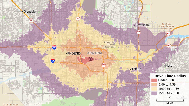
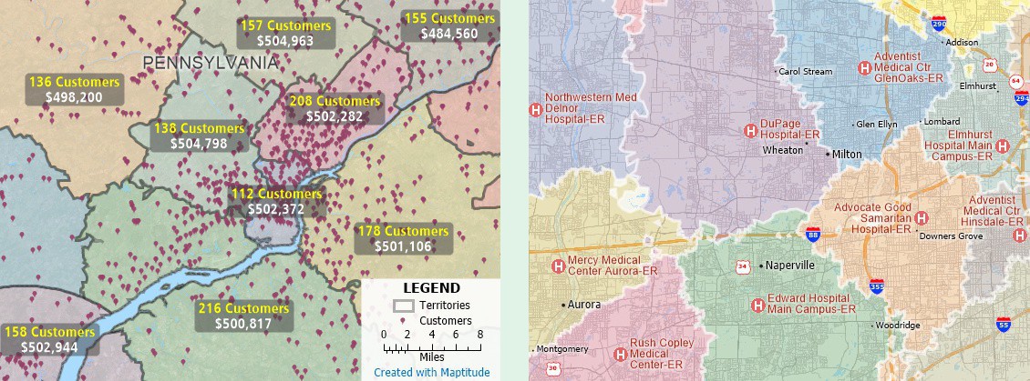
Five-minute interval drive-time band map created with Maptitude MapPoint replacement
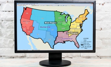
Territory map created with Maptitude MapPoint alternative
Maptitude empowers organizations and businesses to leverage the power of location-based data for better decision-making. As a powerful successor to MapPoint, this competitively priced software goes beyond simply displaying maps; it provides a comprehensive suite of tools to analyze, visualize, and understand complex spatial relationships.
To cater to specific geographic needs once filled by MapPoint, Maptitude offers detailed Country Packages packed with valuable data. These packages include:
| Features | Maptitude | MapPoint |
|---|---|---|
| Tools | ||
| Link and update records | Yes | Yes |
| Routing, territory creation, finding, circle & chart & heat mapping, GPS support, pushpin/address/post code mapping | Yes | Yes |
| GIS-related features and flexibility in defining and presenting data and map layers | Yes | No |
| Drive time rings for multiple origins and with multiple concentric rings per origin | Yes | No |
| Data | ||
| Pushpin limitations | Unlimited | 10,000 |
| Up-to-date Census Tract boundaries, ZIP Codes, Census data and demographics | Yes | No |
| Street data for Guam and other U.S. territories | Yes | No |
| Basic maps of the entire world | Yes | No |
| Detailed coverage and tools for Brazil, Australia, and many other countries | Yes | No |
| UK postal data for Northern Ireland | Yes | No |
| Territories | ||
| Calculate area of overlapping sales regions | Yes | No |
| Redraw territories while seeing the sum value of opportunities within each territory | Yes | No |
| Use selection and drawing tools to export data for regions or territories | Yes | No |
| Create custom territory boundary layers using drawing tools | Yes | No |
| Analysis | ||
| Create multi-ring radius layers around one or more points automatically | Yes | No |
| Create multi-ring drivetime zone layers around one or more points automatically | Yes | No |
| Filters | ||
| Perform map/database filtering | Yes | No |
| Control the map/layer visibility of filters | Yes | No |
| Maps & Styles | ||
| Ability to turn ALL map layers on and off, including the background map style | Yes | No |
| Ability to fully customize any aspect of the map and map styles | Yes | No |
| Use any image type for pushpins | Yes | No Only CUR, ICO, & BMP |
| Support | ||
| Ongoing support for the mapping product and for customer questions | Yes | Discontinued |
| 64-Bit version | Yes | No |
| SQL Server spatial | Yes | Yes |
Identify weighted concentrations of features and over- and under-served areas
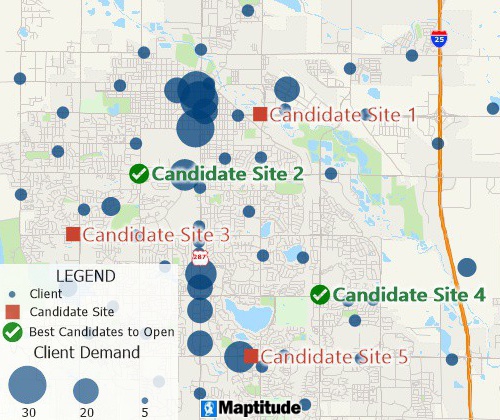
Facility location mapping tools
The last version of MapPoint was MapPoint 2013. Maptitude is the most suitable desktop replacement for MapPoint 2013. If you are looking for MapPoint 2013 replacement software, Maptitude has equivalent and improved features:
Map created with MapPoint 2013 replacement, Maptitude
MapPoint is not still available. The flagship Microsoft mapping product, MapPoint, was discontinued after the release of MapPoint 2013.
The last version of MapPoint was MapPoint 2013. New copies of MapPoint can no longer be downloaded for purchase. Maptitude is one suitable desktop replacement for MapPoint. Maptitude is feature equivalent to MapPoint and supports MapPoint files. Maptitude:
Microsoft's flagship mapping product, MapPoint, was discontinued, along with AutoRoute and Streets & Trips, on December 31, 2014. Online support was available for the products through July 14, 2015. Since then, demographics have changed and new streets and subdivisions have been built. MapPoint data is old. It should not be used for new location-based decisions.
If you are wondering what happened to MapPoint and why you should replace it with Maptitude, here's why:
These make Maptitude an ideal replacement for MapPoint. Maptitude Country Packages allow former AutoRoute customers to also access up-to-date maps.
There is no MapPoint version of MapPoint for the Apple Mac operating system. MapPoint was a Windows application. The software is no longer available for any platform. Maptitude desktop is a MapPoint for Mac alternative. The application can run on Windows installed on a Macintosh. Maptitude Online can be accessed from any browser. This is another option for Mac users that need to analyze maps.
The MapPoint alternative is Maptitude. Maptitude is the closest desktop replacement for MapPoint, Streets & Trips, and AutoRoute. Maptitude Online is a web-based alternative to MapPoint. Maptitude mapping software is a great alternative to MapPoint because it has improved MapPoint features and new data.
After MapPoint was discontinued in 2014, Microsoft released a number of other products that provided similar functionality, such as Bing Maps and Azure Maps. These products are available through a variety of platforms and devices, and they offer a range of features and functionality that are similar to those offered by MapPoint.
Maptitude is a geographic information system (GIS) software program developed by Caliper Corporation. It is a commercial product that is used for mapping and spatial analysis, and it includes a range of features such as geocoding, routing, and spatial analysis tools. While Maptitude is similar to MapPoint in many ways, it is not developed and marketed by Microsoft.
MapPoint can no longer be installed because it was discontinued after the release of MapPoint 2013. MapPoint 2013 was the last version before it was discontinued and does not contain recent geographic changes nor up-to-date demographics. Don't install and use old MapPoint data for new location-based decisions.
Maptitude includes the latest annual updates to nationwide demographics from the U.S. Census and American Community Survey (ACS) and up-to-date HERE street data. Download and install the software here.
MapPoint layers can be used with Maptitude. If you are using outdated MapPoint layers, maps, and data, you can update them in Maptitude. Simply use the Maptitude File>Open command to open your MapPoint pushpins, territories, and waypoints. By using your layers with Maptitude you will get a more accurate picture of your market.
In addition, you will have access to tools that were unavailable to you before. See the table above for a comparison of MapPoint and Maptitude features.
Territories were drawn in MapPoint using the manual drawing tools. MapPoint is no longer available for purchase. The outdated population demographics in older versions of MapPoint should not be used to build territories or to make location-based decisions.
If you need to create, modify, or balance territories, you can use Maptitude. Maptitude has additional territory tools that were not available in MapPoint. With Maptitude, you can:
How do you draw a territory in MapPoint? MapPoint 2013 was the last version of MapPoint. If you need to create territories that are balanced you need to use the latest demographic data. Use Maptitude to build territories that are balanced by population, disposable income, number of customers, total sales, or any other variable. Maptitude can also build territories based on drive-time accessibility.
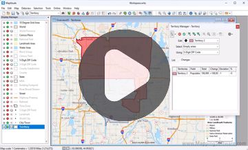
Creating territories interactively with Maptitude
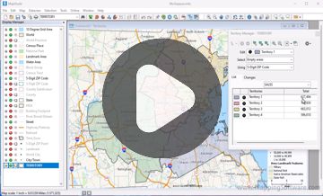
Creating territories from a table with Maptitude
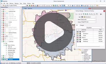
Creating territories from a layer with Maptitude
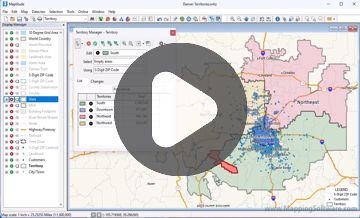
Modifying territories with the Territory Manager
Microsoft MapPoint was discontinued on December 31, 2014. Online support was discontinued on July 14, 2015.
 |
“Maptitude has an incredible number of potential applications. My company purchased it as a major upgrade to the discontinued Microsoft MapPoint. After discovering how much easier it is to accomplish what I did in MapPoint using Maptitude, I am discovering uses for it that were not considered during the time of purchase. I am only scratching the surface of Maptitude's potential applications, and their support team has been incredibly helpful along the way .”
|
 |
“While MapPoint was a decent inexpensive program for someone who needed to make a quick thematic map, it had a minimal amount of functionality. For those who want to take business mapping to the next level, Maptitude is an excellent product with an amazing amount of functionality for the price. Maptitude has an easy learning curve, as everything you need comes in the box.”
|
 |
“We are able to do things with Maptitude that we had not dreamed of doing before (using MapPoint). There are so many possibilities, that you can easily create a mapping solution that perfectly meets the need of your business model.”
|
 |
“I was looking for a replacement to MapPoint, I found it, and it is many times better than the defunct MapPoint. The customer service is great too at Maptitude.”
|
|
|
“MapPoint (is) designed for simple visualization and map creation, while Maptitude offers additional analytical tools that can be used for in-depth geographical analysis.”
|
 Check out our G2 Reviews
Home | Products | Contact | Secure Store
